Figures & data
Figure 1 The UKHO tide gauge locations, including bounds defined for regional statistics.
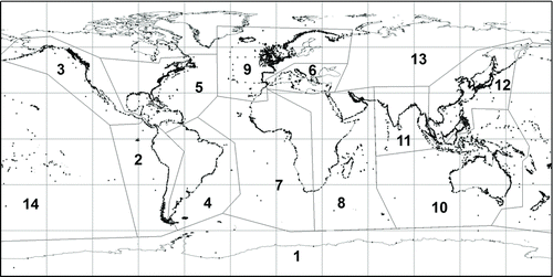
Figure 2 Assessment of global ocean tide models. Agreement with tide gauge LAT values, cumulative RMS (m) as a function of offshore distance where zero denotes position located on a smoothed buffer defined 22 km from land, and positive distance indicates distance from this buffer toward land.
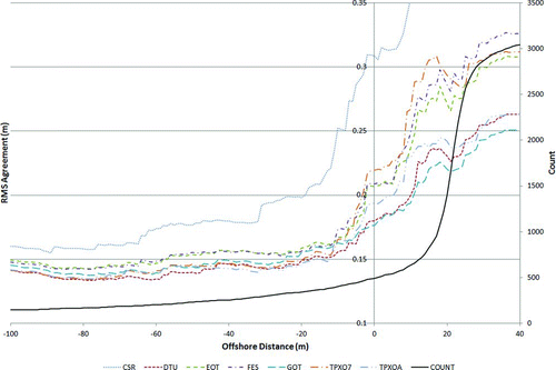
Figure 3 Assessment of global ocean tide models. Difference between the DTU10 predictions of LAT and the UKHO tide gauge predictions of LAT at the 2,569 locations used for the assessment of global ocean tide models (Scenario A, ).
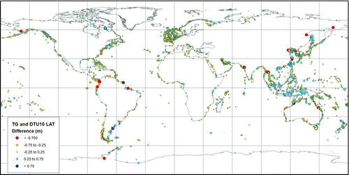
Table 01 Global comparison statistics between tide gauge LAT and global ocean tide model LAT (m). Scenario A includes tide gauges for which LAT levels are available from all tide models and with a cut-off removing gauges located greater than 25 km inshore from the reference buffer (2,569 tide gauges). Scenario B is all offshore tide gauges (i.e., outside the 22 km reference buffer zone; 492 gauges)
Figure 4 The thin plate spline method uses surrounding tide gauge and DTU10 LAT data as control points to define the interpolation. This figure shows the location and values of control points used to interpolate LAT at an example location in the Bay of Fundy. LAT values in meters.
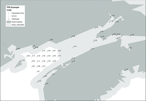
Figure 5 Tuning of the thin plate spline data weighting parameters; RMS agreement (m) of 5,509 tide gauges in the cross-validation method under a range of values of λ0 and β.
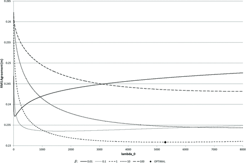
Table 02 Regional breakdown of comparison statistics; RMS agreement (m) between tide gauge LAT values and thin plate spline predicted LAT. (1) The cross-validation (independent) test denotes the statistics whereby surrounding data are used to predict the in-situ tide gauge value. (2) The final surface fit is the agreement between the tide gauge values and the final surface (therefore a measure of precision). For reference, the mean nearest separation between tide gauges is given in the final column
Figure 6 Cumulative RMS agreement (m) between tide gauge LAT values and thin plate spline predicted LAT as a function of offshore distance, where zero denotes position located on a smoothed buffer defined 22 km from land and positive distance indicates distance from this buffer toward land. The respective agreement from the DTU model is included for comparison.
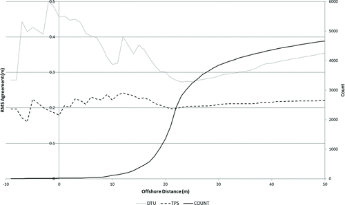
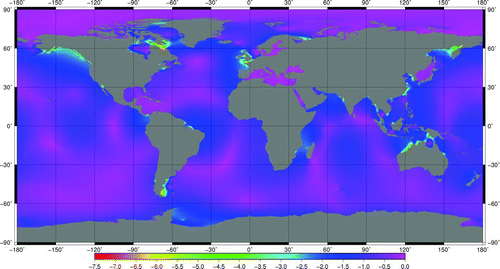
Figure 7 Surface model of lowest astronomical tide with respect to mean sea level (m).