
Figures & data
Figure 1. Distribution of study areas. Source: Map data from OpenStreetMap.Footnote1
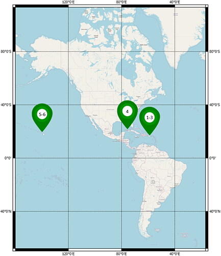
Figure 2. Six AOIs used in this study: AOI-1 (a), AOI-2 (b), AOI-3 (c), AOI-4 (d), AOI-5 (e) and AOI-6 (f). The left pictures show Sentinel-2 Level-2A image, and others present the in-situ depth data from LiDAR or MBES measurements.
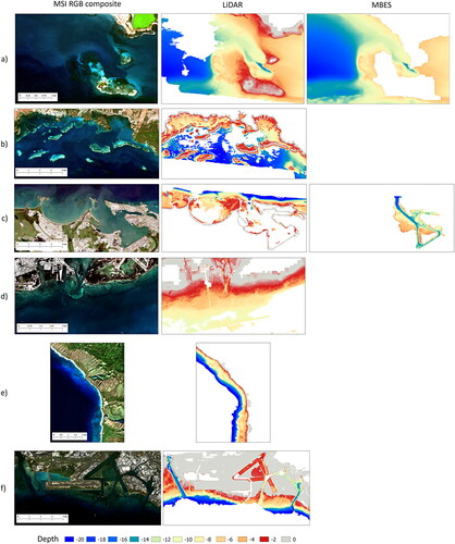
Table 1. An overview of coastal water conditions in each study area.
Figure 3. Sub-images extraction of multispectral images and depth. The pixels illustrate the surface reflectance of Sentinel-2, the white boxes are the window size of 9 × 9, and the dots indicate the water depth values. Spectral bands of each window correspond to the water depth value at the sub-image center.
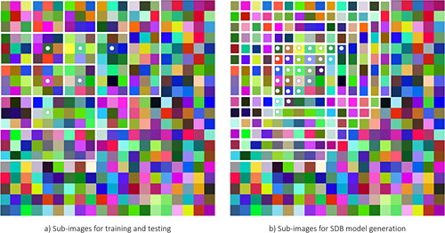
Table 2. Accuracy assessment of SDB using CNN trained in AOI-1, AOI-2, AOI-3, and AOI-4.
Table 3. RMSE values per 5 m depth increment using CNN trained in AOI-1, AOI-2, AOI-3, and AOI-4.
Figure 4. SDB accuracy per 1 m depth range using CNN trained in AOI-1 (orange), AOI-2 (grey), AOI-3 (yellow), and AOI-4 (blue).
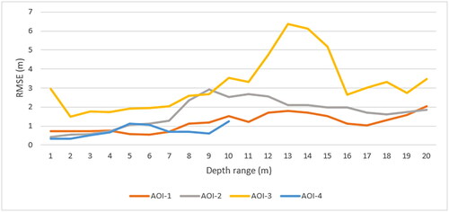
Figure 5. AOI-1 SDB model (left) and cross profiles (right). The cross-section compares the SDB model using CNN trained (blue) and in-situ depth (green).
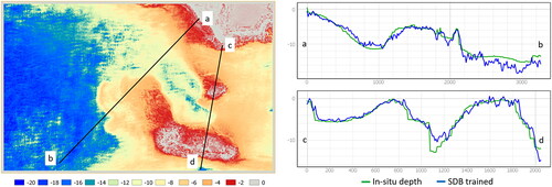
Figure 6. AOI-2 SDB model (left) and cross profiles (right). The cross-section compares the SDB model using CNN trained (blue) and in-situ depth (green).
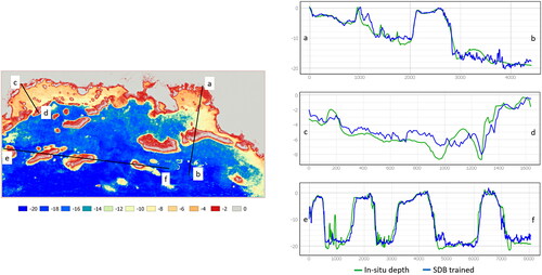
Figure 7. AOI-3 SDB model (left) and cross profiles (right). The cross-section compares the SDB model using CNN trained (blue) and in-situ depth (green).
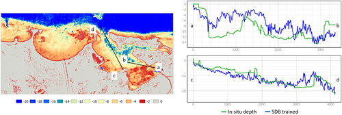
Figure 8. AOI-4 SDB model (left) and cross profiles (right). The cross-section compares the SDB model using CNN trained (blue) and in-situ depth (green).
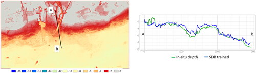
Figure 9. SDB accuracy comparison between results with a single image and multi-temporal images.
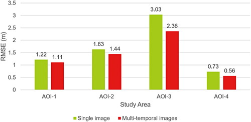
Table 4. SDB accuracy in AOI-5 and AOI-6 using the trained model, pre-trained model of different study areas, and bathymetry model from Allen Coral Atlas.
Figure 10. Prediction vs reference depth plots in AOI-5 using different CNN models: trained (a); pre-trained on AOI-1 (b); pre-trained on AOI-2 (c); pre-trained on AOI-3 (d); pre-trained on AOI-4 (e); pre-trained on the combined AOI-1, AOI-2, and AOI-3 (f); pre-trained on the combined AOI-1, AOI-2, and AOI-4 (g); pre-trained on the combined AOI-1, AOI-2, AOI-3, and AOI-4 (h).
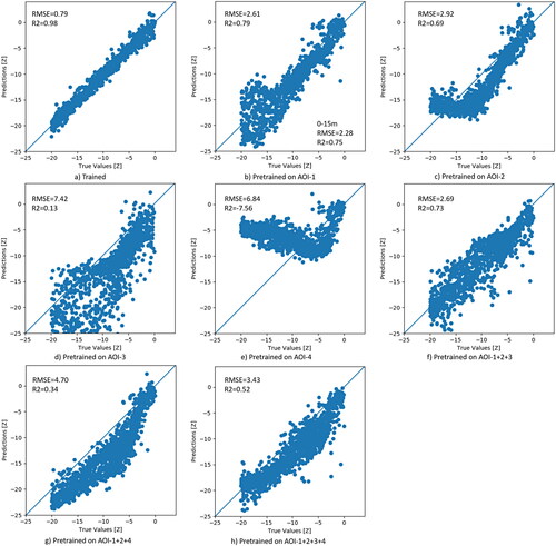
Figure 11. LiDAR bathymetric depths (a) and SDB results in AOI-5 using different CNN models: trained (b); pre-trained on AOI-1 (c); pre-trained on AOI-2 (d); pre-trained on AOI-3 (e); pre-trained on AOI-4 (f); pre-trained on the combined AOI-1, AOI-2, and AOI-3 (g); pre-trained on the combined AOI-1, AOI-2, and AOI-4 (h); pre-trained on the combined AOI-1, AOI-2, AOI-3, and AOI-4 (i).
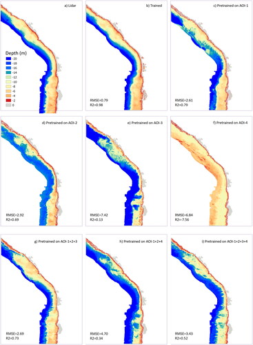
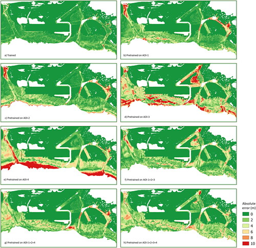
Figure 12. Absolute error of SDB per pixel when using different CNN models: trained (a), pre-trained on AOI-1 (b); pre-trained on AOI-2 (c); pre-trained on AOI-3 (d); pre-trained on AOI-4 (e); pre-trained on the combined AOI-1, AOI-2, and AOI-3 (f); pre-trained on the combined AOI-1, AOI-2, and AOI-4 (g); pre-trained on the combined AOI-1, AOI-2, AOI-3, and AOI-4 (h).
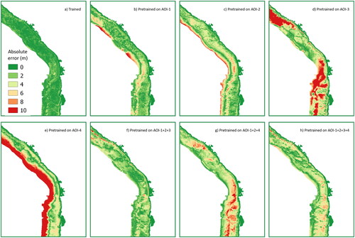
Figure 13. Prediction vs reference depth plots in AOI-6 using different CNN models: trained (a); pre-trained on AOI-1 (b); pre-trained on AOI-2 (c); pre-trained on AOI-3 (d); pre-trained on AOI-4 (e); pre-trained on the combined AOI-1, AOI-2, and AOI-3 (f); pre-trained on the combined AOI-1, AOI-2, and AOI-4 (g); pre-trained on the combined AOI-1, AOI-2, AOI-3, and AOI-4 (h).
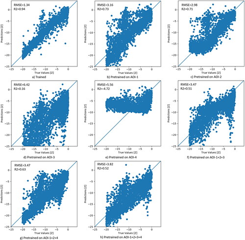
Figure 14. LiDAR bathymetric depths (a) and SDB results in AOI-6 using different CNN models: trained (b); pre-trained on AOI-1 (c); pre-trained on AOI-2 (d); pre-trained on AOI-3 (e); pre-trained on AOI-4 (f); pre-trained on the combined AOI-1, AOI-2, and AOI-4 (g); pre-trained on the combined AOI-1, AOI-2, and AOI-4 (h); pre-trained on the combined AOI-1, AOI-2, AOI-3, and AOI-4 (i).
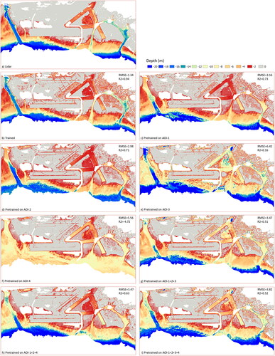
Figure 15. Absolute error of SDB per pixel when using different CNN models: trained (a), pre-trained on AOI-1 (b); pre-trained on AOI-2 (c); pre-trained on AOI-3 (d); pre-trained on AOI-4 (e); pre-trained on the combined AOI-1, AOI-2, and AOI-3 (f); pre-trained on the combined AOI-1, AOI-2, and AOI-4 (g); pre-trained on the combined AOI-1, AOI-2, AOI-3, and AOI-4 (h).
Data availability statement
A complete set of codes, including sample data, is provided in the Github repository at https://github.com/yustisiardhitasari/sdbcnn. The data that support the findings of this study are openly available in the Copernicus Open Access Hub at https://scihub.copernicus.eu/, the National Oceanic and Atmospheric Administration (NOAA) Bathymetric Data Viewer at https://www.ncei.noaa.gov/maps/bathymetry/ and the NOAA Data Access Viewer at https://coast.noaa.gov/dataviewer/. Map data copyrighted OpenStreetMap contributors and available from https://www.openstreetmap.org