
Figures & data
Figure 1. Map of the Scheldt Estuary with the lower reaches (Bath to Vlissingen) located in the Netherlands and the middle to upper reaches (Antwerp harbour to Gent) located in Flanders, a province of Belgium. The characteristics of the Long Term Vision agreed bilaterally in 2001 are listed.
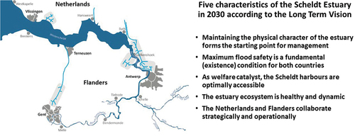
Figure 2. The process followed in developing the Long Term Vision for the Scheldt Estuary, specifying each of the four steps of the process. The Long Term Vision is characterized in terms of accessibility, flood safety, nature and the morphology of the estuary.
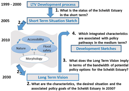
Figure 3. The integrated three-level hybrid modelling system that translates hydro-morphological simulations via ecologically relevant indicators to characteristic abiotic zones and physiotopes, which are linked through the conceptual ecosystem model at its heart to the ecosystem goals (Slinger, Citation2000).
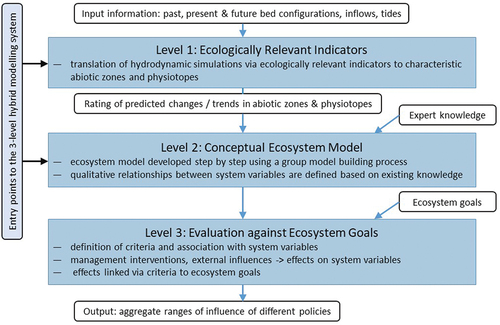
Table 1. Combinations of management interventions and exogenous developments (cases) considered relevant in assessing the response of the natural environment of the Scheldt Estuary.
Table 2. Aggregated range within which the criteria vary until the seventh iteration (no further changes occur thereafter) for 11 cases. .
Data availability statement
Supplementary data on the meetings of the NWG are available from the author upon substantiated and reasonable request as they contain personal information and would have to be individually redacted.