Figures & data
Fig. 1 Schematic illustration of the River Morava catchment in the territory of the Czech Republic, indicating the section of the river studied and the hydrological stations used in the study.
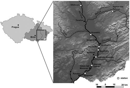
Table 1 Selected characteristics of the hydrological stations used for the study on the River Morava (Q a : long-term mean annual discharge, 1931–1980)
Table 2 Proportion (%) of individual categories of land use in the River Morava catchment (from its source to the Dyje mouth) in the four selected periods
Fig. 2 Changes in land use of the River Morava catchment (from its source to the Dyje mouth) between the years 1836–1841 and 2002–2006.
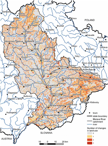
Fig. 3 The section of the River Morava between Uherské Hradiště (Hradisch) and Rohatec (Rohatez) on the Norbert von Linck map, 1719 (Source: MZA – D22). The river was of anabranching character with several meandering channels in many places.
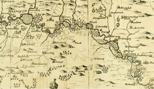
Table 3 Reservoirs on the tributaries of the River Morava (Broža et al., Citation2005)
Fig. 4 Variation of floods exceeding the two-year peak discharge Q 2 at four hydrological stations on the River Morava in the period 1916–2009 with respect to their N-year return period and their occurrence in the summer (1: May–October) and the winter (2: November–April) hydrological half-years (* denotes the half-years in which there occurred more than one flood with Qk ≥ Q 2; ↓ denotes the beginnings of the series of peak discharges).
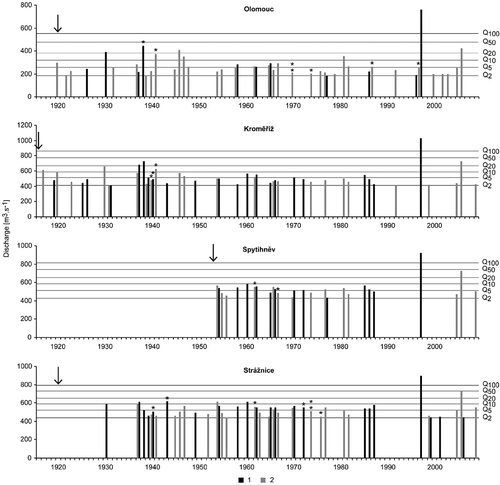
Fig. 5 Comparison of relative frequencies for the concurrent occurrence of floods with Q 2, Q 5, Q 10, Q 20 for station couples on the middle Morava (OLOM: Olomouc; KROM: Kroměříž; SPYT: Spytihněv; STRA: Strážnice), and/or on the Bečva (TEPL: Teplice nad Bečvou), always for the common longest period of measurements at the given couple of stations (see ). Figures at each couple indicate percentage of all common floods with Qk ≥ Q 2 in relation to the station downstream.
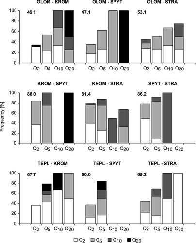
Fig. 6 Fluctuations of relative annual peak water stages at selected hydrological stations on the middle Morava in the years 1881–1920 and frequency of floods per year of the summer (1) and winter (2) types.
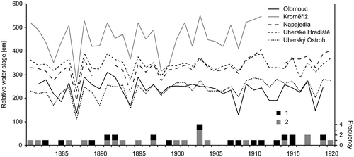
Table 4 List of floods recorded in documentary evidence for the middle Morava in the 16th–17th centuries
Fig. 7 Decadal frequencies of floods on the middle Morava according to documentary evidence in the period 1691–1880 and differentiation of flood types (1: summer, 2: winter, 3: unclear).
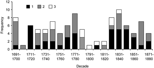
Fig. 8 Decadal frequencies of the occurrence of floods on the middle Morava in the years 1691–2009 according to systematic instrumental measurements and documentary sources and differentiation of flood types (1: summer, 2: winter, 3: unclear).
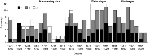
Fig. 9 Component scores of the first principal component PC1 calculated using PCA for 26 winter floods on the River Morava at Kroměříž in the days D – 4 to D – 1 for the period 1881–2003 (L: low; H: high). Explained variance of the SLP field: D – 4: 37.0%; D – 3: 37.1%; D – 2: 34.6%; and D – 1: 29.0%. The black dot shows the position of the Morava catchment.
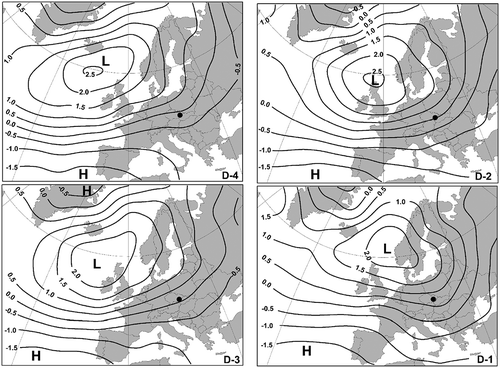
Fig. 10 Component scores of the first principal component PC1 calculated using PCA for 26 summer floods on the River Morava at Kroměříž in the days D – 2 to D – 1 for the period 1881–2003 (L: low; H: high). Explained variance of the SLP field: D – 2: 36.7%; and D – 1: 35.6%. The black dot shows the position of the River Morava catchment.
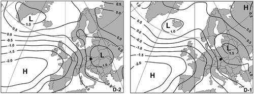
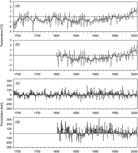
Fig. 11 Temperature and precipitation fluctuations over the past 318 years: (a) annual Central European temperatures, 1691–2008; (b) annual Brno temperatures, 1799–2008; (c) summer Brno precipitation totals, 1691–2008; and (d) annual Brno precipitation totals, 1803–2008. Values are expressed as deviations from the corresponding 1961–1990 means and smoothed by Gaussian filter over 30 years.