Figures & data
Fig. 1 The River Morava within the Strážnické Pomoraví region.
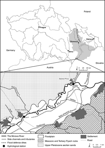
Table 1 Morphometric characteristics of the River Morava channel in the section between the road bridge at Bzenec-Přívoz and the road bridge at Rohatec
Fig. 2 Eroding bank of the River Morava in the downstream part of the meander loop in the Osypané břehy locality. Bank erosion has exposed sediments of the sand dunes of the “Moravian Sahara”. The bank to the left of the aeolian sands was created by loamy alluvial deposits (photo by L. Krejčí, January 2008).
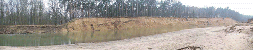
Fig. 3 Fluctuations of anomalies of: (a) annual mean temperatures and (b) annual precipitation totals of the Brno station, 1881–2010. Smoothed by Gaussian filter over 30 years; horizontal lines express corresponding means of the reference period 1961–1990.
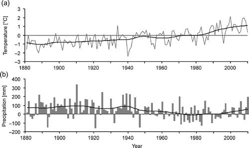
Fig. 4 Drainage system of the River Morava in the Strážnické Pomoraví region in: (a) 1882, (b) 1950, and (c) 2008 according to historical maps and aerial photos.

Fig. 5 Aerial views of the Osypané břehy locality showing the channel of the River Morava in 2003 (a) and after channel shortening in 2006 (b). The inflow and outflow parts of the old meander bend filled up with fluvial sediments soon after the cut-off formed. Visible at (b) is a high bank scour in the left meander, created by erosion of sands shown in (photo by J. Wenzel).
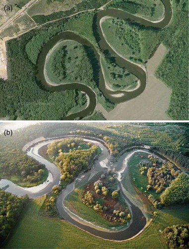
Table 2 List of hydrological stations used in this study and selected characteristics
Fig. 6 Annual peak discharges of the River Morava for the Rohatec/Strážnice stations in the 1921–2010 period with respect to their occurrence in the winter (November–April) and summer (May–October) hydrological half-years. A variety of discharge return frequency levels (from Q 2 to Q 100) are indicated.
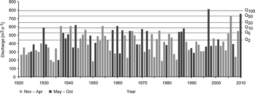
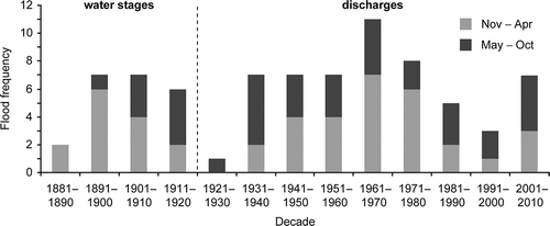
Fig. 7 Decadal frequencies of the occurrence of floods above the two-year peak discharge (≥Q 2 according to their N-year return period on the River Morava for the Rohatec/Strážnice stations in the period 1921–2010.
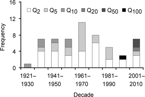
Fig. 8 Annual variation of frequencies of flood occurrence with above two-year discharge (≥Q 2) according to their N-year return period for the River Morava at the Rohatec/Strážnice stations in the period 1921–2010.
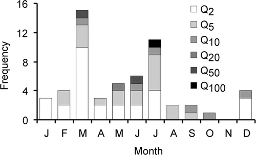
Fig. 9 (a) Period of measurements during the year, and (b) annual peak water stages H max at the Rohatec above-weir (1886–1911) and Rohatec below-weir (1889–1911) stations. Black columns indicate highest peak water stage for years in which incomplete series exist, i.e. these do not necessarily correspond to highest annual peak water stage in equivalent years.
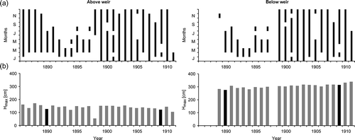
Fig. 10 Fluctuations in relative annual peak water stages of the River Morava at the upstream stations of Rohatec, Uherské Hradiště, Uherský Ostroh and Veselí nad Moravou (above/below weir) for the 1881–1920 period (for stations see ).
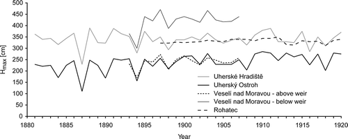
Fig. 11 Synthesis series of decadal frequencies of floods of the River Morava at the Rohatec/Strážnice stations in the 1881–2010 period with respect to their occurrence in the winter (November–April) and summer (May–October) hydrological half-years. Flood frequencies were derived from annual peak water stages (Hk ≥ H 2) of Uherský Brod and Uherské Hradiště (1881–1885), peak water stages (Hk ≥ H 2) of Rohatec (1886–1920) and peak discharges (Q k ≥ Q 2) of Rohatec (1921–1939) and Strážnice (1940–2010).