Figures & data
Fig. 2 Monthly standardized time series of July precipitation anomalies (1958–2002) in six grid point locations across Europe and the station-based CRU NAOI (1958–2002) [Key as Fig. 1].
![Fig. 2 Monthly standardized time series of July precipitation anomalies (1958–2002) in six grid point locations across Europe and the station-based CRU NAOI (1958–2002) [Key as Fig. 1].](/cms/asset/f870683f-0414-4f0b-b153-2d7749f7b102/thsj_a_754545_o_f0002g.gif)
Fig. 1 Monthly standardized time series of January precipitation anomalies in six grid point locations across Europe and the station-based CRU NAOI (1958–2002). The areas shown are: (a) western Scotland (57.25°N, 5.25°W), (b) Norway (65.25°N, 13.75°E), (c) southern Spain (37.75°N, 3.75°W), (d) central France (47.25°N, 3.25°E), (e) Czech Republic (49.75°N, 15.25°E), and (f) Balkans (42.75°N, 20.25°E). The CRU NAOI–precipitation Spearman correlations are given for each of the six precipitation grids with the significance level α (NA implies the correlation is not significant at the 0.05 level). The precipitation time series are solid black lines and the CRU NAOI time series are shaded solid grey.
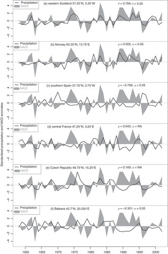
Fig. 3 Number of field significant months for MSLP for: (a) winter (DJF), (b) spring (MAM), (c) summer (JJA) and (d) autumn (SON) (period of study is September 1957 to August 2002).
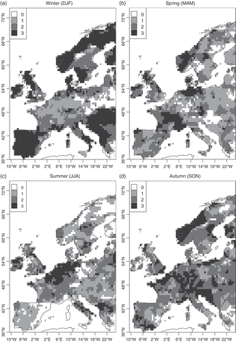
Fig. 4 The empirical bootstrap distribution of the correlation from the 1000 realizations between the February precipitation time series with the strongest increasing trend (62.25°N, 9.75°E; Norway) and the MSLP time series (70°N, 7.5°W) with the highest observed correlation with precipitation. Solid vertical line is the 95% percentile; dashed line is correlation ρ = 0.
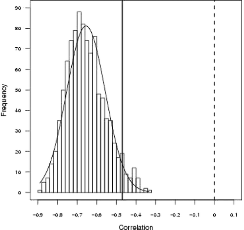
Fig. 5 Correlation analysis of precipitation in a single grid in western Scotland (57.25°N, 5.25°W; location given by black box) with MSLP in January (1958–2002). Shading signifies significant Spearman rank correlation (significance level α = 0.05) (cf. Fig 6).
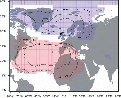
Fig. 6 Correlation analysis of gridded precipitation over the British Isles with MSLP for January 1958–2002. The grey background in each grid box represents the land masses in the study domain and the geographical map shown in the top-left corner represents the spatial domain used. Red (blue) colour signifies significant positive (negative) Spearman rank correlation (significance level a = 0.05).
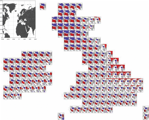
Fig. 10 Correlation analysis of gridded European precipitation with MSLP for October 1957–2001 [Key as Fig. 6].
![Fig. 10 Correlation analysis of gridded European precipitation with MSLP for October 1957–2001 [Key as Fig. 6].](/cms/asset/4d510534-fc5a-4cc8-aa37-a67aec77c0b8/thsj_a_754545_o_f0010g.jpg)
Fig. 9 Correlation analysis of gridded European precipitation with MSLP for July 1958–2002 [Key as Fig. 6].
![Fig. 9 Correlation analysis of gridded European precipitation with MSLP for July 1958–2002 [Key as Fig. 6].](/cms/asset/974eb468-9545-41d3-b9c6-0c580ab76885/thsj_a_754545_o_f0009g.jpg)
Fig. 7 Correlation analysis of gridded European precipitation with MSLP for January 1958–2002 [Key as Fig. 6].
![Fig. 7 Correlation analysis of gridded European precipitation with MSLP for January 1958–2002 [Key as Fig. 6].](/cms/asset/30ff4e6c-5f87-4385-9a0c-f6dc4e1df9e1/thsj_a_754545_o_f0007g.jpg)
Fig. 8 Correlation analysis of gridded European precipitation with MSLP for April 1958–2002 [Key as Fig. 6].
![Fig. 8 Correlation analysis of gridded European precipitation with MSLP for April 1958–2002 [Key as Fig. 6].](/cms/asset/e484060e-26e6-4566-9b5a-70f7bf1c0c3a/thsj_a_754545_o_f0008g.jpg)