
Figures & data
Table 1 Main geomorphological properties of the selected river reaches. DAu and DAd: drainage area subtended by the upstream and downstream section, respectively; DAint: intermediate drainage area; L: channel length; S0: mean channel slope.
Fig. 1 Po River: location of the selected hydrometric sections.
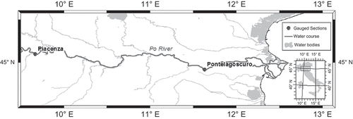
Fig. 2 Tiber River: location of the selected hydrometric sections.
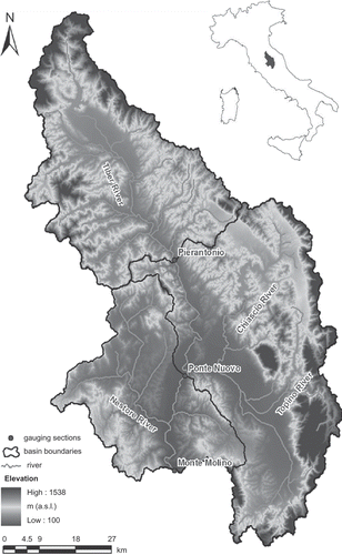
Table 2 Po River—Piacenza-Pontelagoscuro reach: main characteristics of the investigated floods (Qp: peak discharge; TL: observed wave travel time). The percentage of observed stages within the confidence interval (hCI) is also shown, along with the AW of the 90%CI for all the selected events.
Table 3 Tiber River reaches: main characteristics of the investigated floods (Qp: peak discharge; TL: observed wave travel time). The percentage of observed stages within the confidence interval (hCI) is also shown, along with the AW of the 90%CI for all the selected events.
Table 4 RCM-RT parameters for all the investigated reaches, wherein αmeanT and βmeanT are the RCM characteristic parameters and ∆t* is the forecast lead time. See for abbreviations.
Fig. 3 Linear relationship between the downstream discharge, Qd, and the quantity (Ad(t + TL)/Au(t))Qu(t) for the Piacenza-Pontelagoscuro reach (six calibration events): (a) mean (TL = 32 h) and (b) observed wave travel time; the Pierantonio-Monte Molino reach (14 calibration events): (c) mean (TL = 9 h) and (d) observed wave travel time; and the Ponte Nuovo-Monte Molino reach (14 calibration events): (e) mean (TL = 4 h); and (f) observed wave travel time.
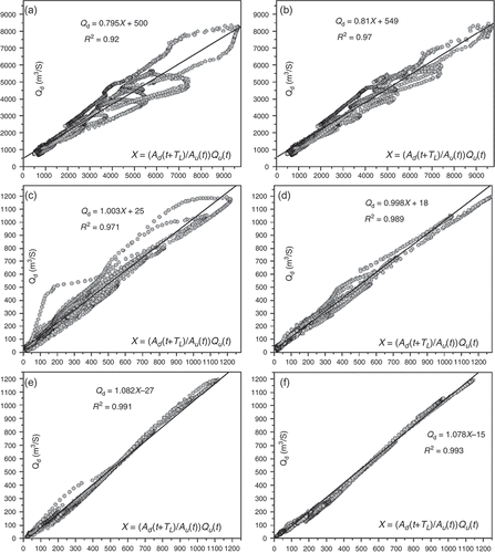
Table 5 Percentage lateral flow for all the investigated case studies. The variation range and mean, m (both in absolute value) of the evaluation measures of the RCM-RT performance are also shown (eQp: error in peak discharge; ehp: error in peak stage; PCris: coefficient of persistence for rising limb; NS: Nash-Sutcliffe efficiency coefficient).
Table 6 Statistical analysis of the RCM parameters α and β. SD: standard deviation.
Fig. 4 Piacenza-Pontelagoscuro reach (Po River, ∆t* = 32 h): comparison between observed and forecast hydrograph provided by the RCM-RT model for: (a) and (b) the calibration flood event of December 2002; (c) and (d) the validation flood event of 26 September 2006. The assessed CI is also shown along with the alarm threshold.
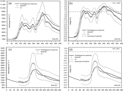
Fig. 5 Pierantonio-Monte Molino reach (Tiber River, ∆t* = 9 h): comparison between observed and forecast hydrograph provided by the RCM-RT model for: (a) and (b) the calibration flood event of February 2009; (c) and (d) the validation flood event of January 2010. The assessed CI is also shown along with the warning and alarm hydrometric thresholds.
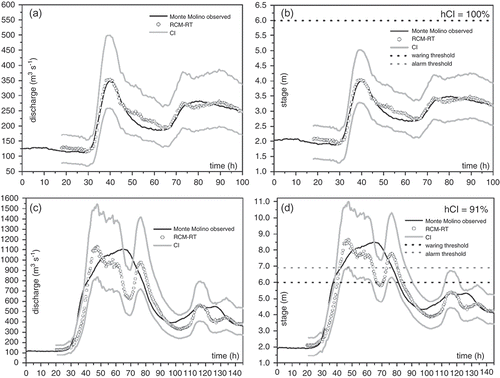
Fig. 6 Ponte Nuovo-Monte Molino reach (Tiber River, ∆t* = 4 h): comparison between observed and forecast hydrograph provided by the RCM-RT model for: (a) and (b) the calibration flood event of 30 December 2005; (c) and (d) the validation flood event of 2 December 2005. The assessed CI is also shown along with the warning and alarm hydrometric thresholds.
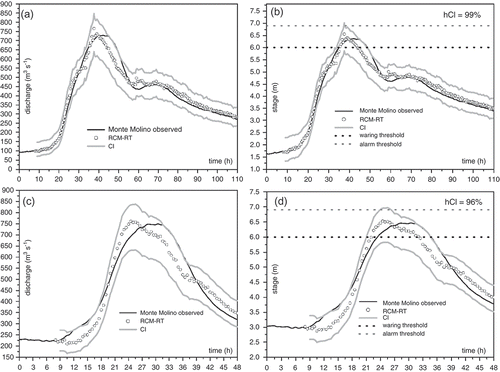
Table 7 Contingency table showing the capability of the RCM-RT model to predict exceedence/non-exceedence of hydrometric thresholds. halarm: alarm threshold; hwar: warning threshold.