Figures & data
Figure 1. Map of Miyun Reservoir. The circles show the locations of the eight monitoring sites: M1 stands for Baihe station, M2 for Kuxi, M3 for ShuiJiu, M4 for Chaohe, M5 for Taoli, M6 for Henghe, M7 for Kudong and M8 for Jingou station.
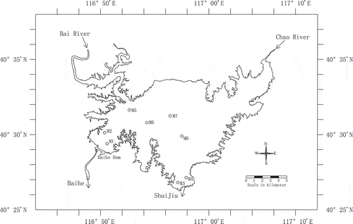
Figure 2. (a) Water surface elevation from 1992 to 2011 (MSL stands for mean sea level), and (b) bathymetry curves for Miyun Reservoir (cumulative volume and horizontal area vs water level).
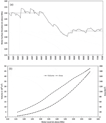
Figure 3. Average and standard deviation (StdDev) series of measured water temperatures at (a) the surface depth (0.5 m), (b) the middle depths and (c) the bottom depths calculated from available measurements at eight different sites M1–M8 () in Miyun Reservoir for the periods 1998–2005 and 2006–2011.
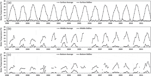
Figure 4. Inter-annual variation of (a) air temperature at the Miyun and Beijing Weather Stations, (c) total river inflow from 1990 to 2011, and (e) measured and back-calculated outflow for water supply from 1998 to 2011. Frequency distributions (histograms) of these three parameters are shown in (b), (d) and (f), respectively.
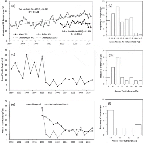
Figure 5. (a) Time series of measured and simulated water levels under the scenarios S1, S2 and S3; (b) annual water inputs (direct precipitation, ungauged runoff and river inflow) and losses (outflow and evaporation) in Miyun Reservoir from 1998 to 2011.
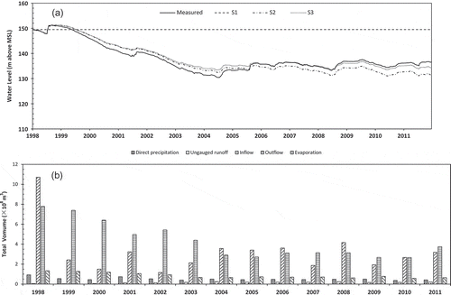
Figure 6. Simulated water temperatures at the surface depth (0.5 m) under (a) scenario S1, (b) scenario S2 and (c) scenario S3 compared against mean measured temperatures (including average values ±1 SD) in Miyun Reservoir for 1998–2011.
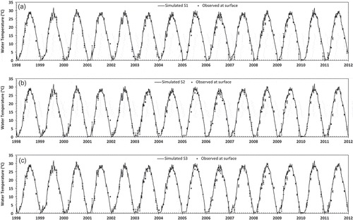
Figure 7. Simulated water temperatures at the middle depths under (a) scenario S1, (b) scenario S2 and (c) scenario S3 compared against mean measured temperatures (including average values ±1 SD) in Miyun Reservoir for 1998–2011.
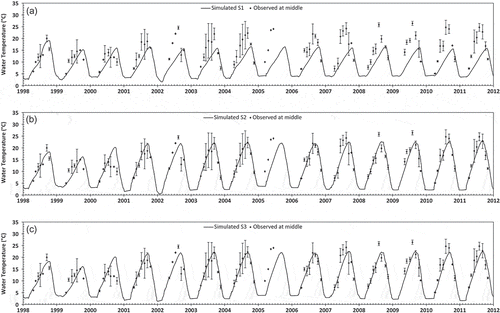
Figure 8. Simulated water temperatures at the bottom depths under (a) scenario S1, (b) scenario S2 and (c) scenario S3 compared against mean measured temperatures (including average values ±1 SD) in Miyun Reservoir for 1998–2011.
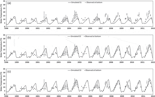
Table 1. Description of different simulation scenarios.
Table 2. Error parameters computed between measured and simulated temperatures under scenarios S1, S2 and S3.
Table 3. Parameters used to define long-term water temperature characteristics in Miyun Reservoir.
Table 4. Simulated annual values of seven parameters () used to define long-term water temperature characteristics from 1998 to 2011 under scenario S3.
Figure 9. Simulated annual maximum and mean (a) surface water temperatures, (b) bottom water temperatures and (c) differences of temperatures between the surface and bottom depths; and (d) simulated stratification days (Str. Days) under scenarios S1 and S3 in Miyun Reservoir (1998–2011).
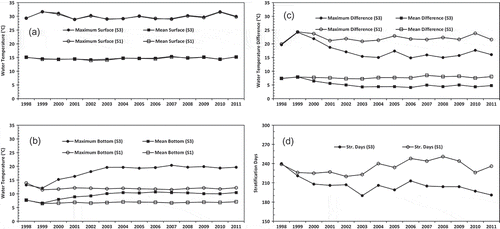
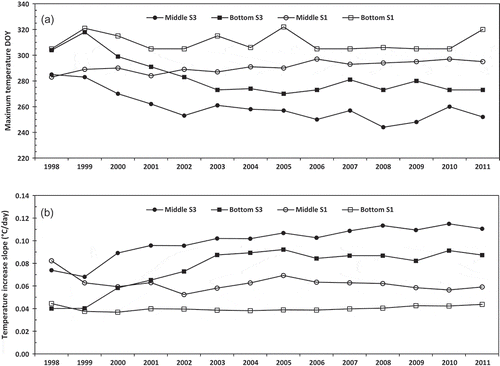
Figure 10. (a) Day of the year (DOY) having the maximum water temperatures in the middle depths and bottom depths, (b) slopes of temperature increases during the period from April 1 to the day of maximum water temperatures at the middle depths and bottom depths simulated under scenarios S1 and S3.