Figures & data
Figure 1. Angola geography, provincial capitals and main rivers.
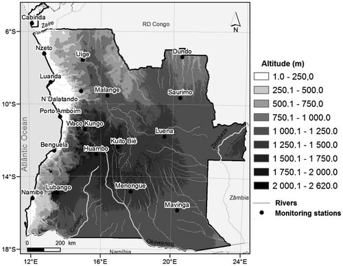
Table 1. Number of monitoring stations with records collected for the current research.
Figure 2. Locations of (a) precipitation, (b) temperature and (c) evaporation monitoring stations used in the study. The vertical lines show the transects used in , and .
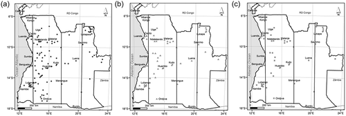
Table 2. Summary of the global atmospheric re-analysis exercises used.
Figure 3. Mean annual precipitation maps for 1959/60–1973/74 obtained by co-kriging interpolation from ground observation measurements and re-analysis estimates (values in mm).
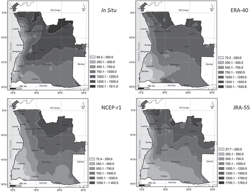
Figure 4. North–south transect of mean annual precipitation of the 1959/60–1973/74 record obtained at longitudes 13°50ʹE, 17°35ʹE and 20°20ʹE.
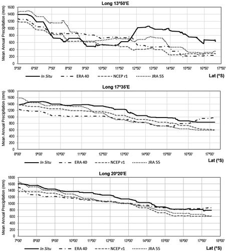
Figure 5. Annual precipitation and seasonal precipitation values obtained from the re-analysis datasets against in situ records for 1959/60–1973/74. Each point represents a monitoring site and one year or season (values in mm).
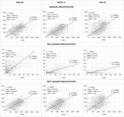
Figure 6. Performance indicators of annual precipitation estimates from ERA-40, NCEP-r1 and JRA-55 re-analysis exercises using the period 1959/60–1973/74. Each point represents a monitoring site.
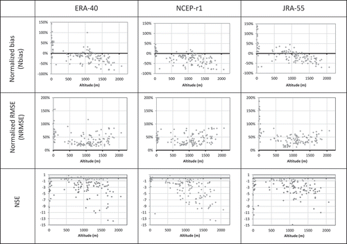
Table 3. Performance indicators of annual precipitation and seasonal precipitation values obtained from the re-analysis datasets and the ensemble means of the re-analysis against in situ records for the period 1959/60–1973/74.
Figure 7. Mean temperature map for 1959/60–1973/74 obtained by co-kriging interpolation from ground observation measurements and re-analysis estimates.
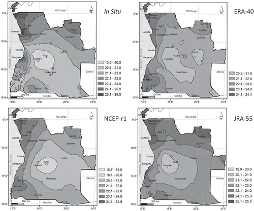
Figure 8. North–south transect of average temperature of the 1959/60–1973/74 record obtained at longitudes 13°50ʹE, 17°35ʹE and 20°20ʹE.
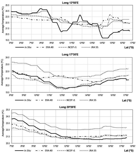
Figure 9. Mean temperature values obtained from the re-analysis datasets against in situ records for 1959/60–1973/74. Each point represents a monitoring site and one year or season (values in °C).
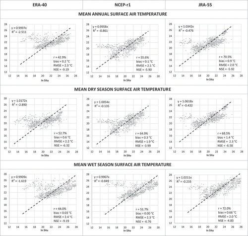
Figure 10. Performance indicators of mean temperature estimates from ERA-40, NCEP-r1 and JRA-55 re-analysis exercises for 1959/60–1973/74. Each point represents a monitoring site.
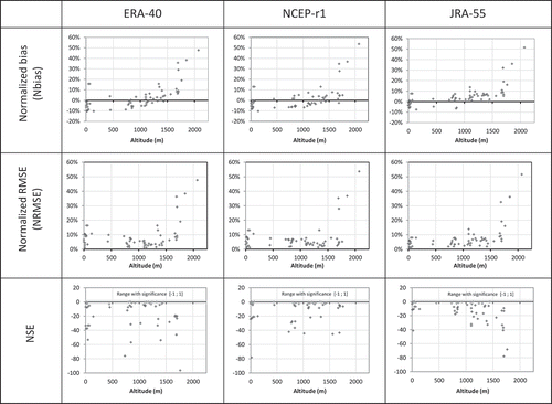
Table 4. Performance indicators of mean surface air temperature values obtained from the re-analysis datasets and the ensemble means of the re-analysis against in situ records for the period 1959/60–1973/74.
Figure 11. Mean annual evaporation map for 1959/60–1973/74 obtained by co-kriging interpolation from ground observation measurements and re-analysis estimate (values in mm).
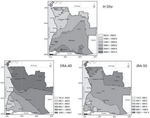
Figure 12. North–south transect of mean annual evaporation of the 1959/60–1973/74 record obtained at longitudes 13°50ʹE, 17°35ʹE and 20°20ʹE.
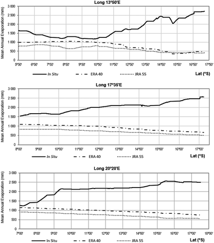
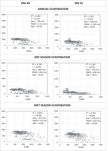
Figure 13. Annual evaporation values and seasonal evaporation values obtained from the re-analysis datasets against in situ records for 1959/60–1973/74. Each point represents a monitoring site and one year or season (values in mm).