Figures & data
Table 1. Distribution of Local Government Areas (LGAs) among remoteness classes in Australian States and Territories
Table 2. Protocol for evaluating the quality and coverage of planning policy for natural hazards across all Local Government Areas in Australia. Each item was coded as one of three options: 0 (no policy provision); 1 (some policy provision) or 2 (thorough policy provision), giving an overall maximum possible planning policy score of 14
Table 3. Overview of planning policy scores in Australian States and Territories. The mean planning policy score was computed from all LGAs within a State/Territory. The distribution of planning policy scores among LGAs was computed as the number of LGAs in each State/Territory with each planning policy score (4–14). No planning policy scores between 0–3 were observed
Table 4. Scores for items in the three policy levels of the assessment protocol. Items contributing to each policy level are explained in . Item scores at the State Government level are n = 1, while other policy levels are means of component LGAs
Figure 1. Distribution of local-level (a) bushfire and (b) flood hazard mapping (map) and development control (control) scores across Australian States and Territories. Values show the proportion of LGAs in each state coded as 0 (no provision), 1 (partial provision) or 2 (thorough provision) for the relevant item. Items are explained in . The ACT was not assessed because it only consists of one LGA.
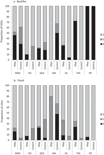
Figure 2. Planning policy score distribution among population density quintiles.
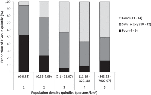
Figure 3. Distribution of planning policy scores among metropolitan, regional city and rural/remote classes of LGAs. Remoteness classes are described in .
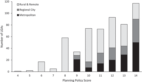
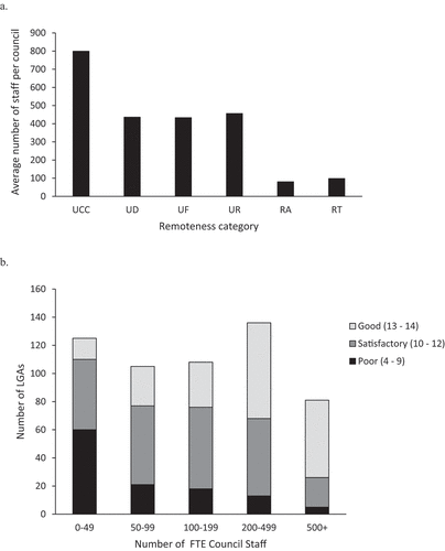
Figure 4. Council staffing and planning policy scores. (a) Average council FTE staff per remoteness class. (b) Planning policy score distribution among staffing levels. Remoteness classes are explained in . Brisbane was excluded from the UCC class, as the LGA covers much of the Brisbane metropolitan area, and is an outlier with >7000 FTE staff.