
Figures & data
Figure 1. Map of the Dongjiang River basin showing the location of the study area and sampling sites of three land use sites.
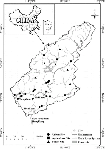
Table 1. Summary of the environmental factors investigated in the present study. The data are presented as the mean ± SE for three land use categories. Minimum and maximum values are shown in brackets.
Table 2. Results of ANOVAs of environmental factors of different land use sites. Asterisks indicate P < 0.05. The results of post hoc tests among the three land use sites are indicated by superscripts, and significant differences (p < 0.05) are indicated by different letters.
Figure 2. Stacked bar plots showing the percentage contributions to the macroinvertebrate FFGs (relative abundance) of different land use sites. SH = shredders, FC = collector-filterers, GC = collector-gatherers, SC = scrapers, PR = predators.
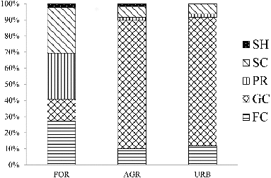
Figure 3. Density (mean ± SE, individual m−2, left bar) and richness (mean ± SE, right bar) for FFGs of different land uses. Data with no superscript letters show there is no significant differences among sites (p < 0.05). SH = shredders, FC = collector-filterers, GC = collector-gatherers, SC = scrapers, PR = predators.
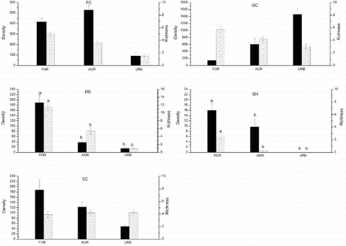
Figure 4. Redundancy analysis (RDA) tri-plot relating macroinvertebrate FFG communities to environmental factors of 30 sites. Significant environmental factors (p < 0.05) were TP, ELE, ORD and SUB. ELE = elevation; ORD = stream order; SUB = substrates. Different symbol represent different land use sites (forest: △; agriculture:□; urban:○). SH = shredders, FC = collector-filterers, GC = collector-gatherers, SC = scrapers, PR = predators.
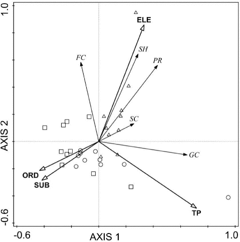
Table 3. Summary statistics for the redundancy analysis (RDA) relating macroinvertebrate FFG communities to environmental factors. The important factors in axis 1 and axis 2 are shown in bold. ELE = elevation; ORD = stream order; SUB = substrates.
Table A1. Identified macroinvertebrate taxa with respect to their corresponding FFGs.