
Figures & data
Figure 1. Finsbury Park and surrounds (map by Miles Irving)
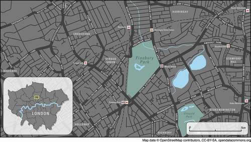
Figure 2. A) Map extracted from Haringey Council (Citation2019) Introducing: Finsbury Park [pdf leaflet]. B) Photo of basketball courts courtesy of Sean Fitzimmons. C) Photo of Finsbury Park bench licensed under creative commons from “spiraltri3e” www.flickr.com. D) Photo of footballers “12. They are Here” licensed under creative commons, installation at Furtherfield Gallery, photographer: Annalisa Sonzogni. E) Photo of perimeter fences, authors own. F) Photo of field with sign, authors own. G) Photo of major event, authors own
![Figure 2. A) Map extracted from Haringey Council (Citation2019) Introducing: Finsbury Park [pdf leaflet]. B) Photo of basketball courts courtesy of Sean Fitzimmons. C) Photo of Finsbury Park bench licensed under creative commons from “spiraltri3e” www.flickr.com. D) Photo of footballers “12. They are Here” licensed under creative commons, installation at Furtherfield Gallery, photographer: Annalisa Sonzogni. E) Photo of perimeter fences, authors own. F) Photo of field with sign, authors own. G) Photo of major event, authors own](/cms/asset/76c5317f-9c4f-479f-8b57-b4fde744fa6c/rurb_a_1934631_f0002_oc.jpg)
Table 1. Six registers of sociality