Figures & data
Figure 1. Site map of the two marine terrace locations – Albion in Mendocino, County, and Davenport in Santa Cruz County, California. Map by T.R. Paradise.
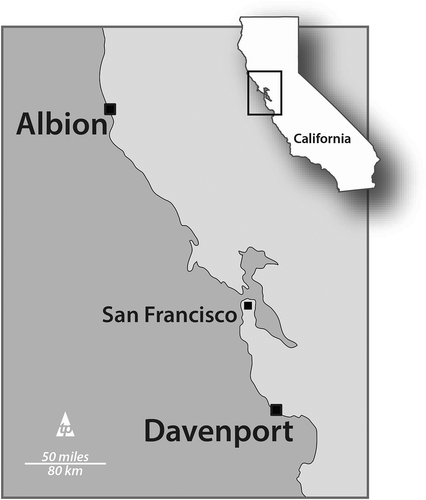
Figure 2. Site map identifying the locations of the pygmy Cypress and ashen-soil (podzolic) ecosystems. The dwarf “forests” are found on the eastern flanks of the second, third, and fourth terraces as mapped by Jenny (Citation1973). It was the occurrence of these dwarf trees on podzols that triggered early research into the geomorphologic origins of these ecologic staircases. Map by T.R. Paradise.
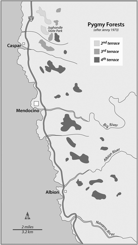
Figure 3. Mendocino County’s marine terraces: first, second, and third. The fourth terrace is somewhat visible with cleared ground above the third. Jenny’s (Citation1973) ‘zero terrace is visible here as the wave-cut platform interspersed with pocket beaches and caves. Image: commons.wikimedia.org/wiki/File:Marine_terraces_California.jpg.
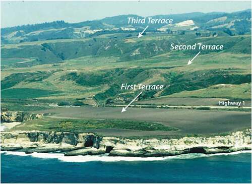
Figure 4. An oblique diagram of the surface and cross-sections of the Jug handle ecological Staircase showing the repeated substrate composition of each terrace: dunal ridge, coastal sediments and hardpan and podzols supporting the dwarf Cypress forests. Diagram by T.R. Paradise after Jenny (Citation1973), Schulz et al. (Citation2018).
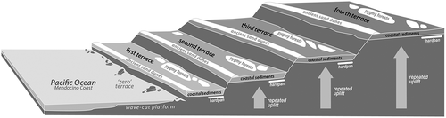
Figure 5. An orthophotograph and topographic representation of the Mendocino County marine terraces at the confluence of the Navarro River and Pacific Ocean, near Albion, California. Note that the terraces here are relatively similar in dimension and spacing – both laterally and vertically. Jenny’s (Citation1973) wave-cut platform and offshore stacks, arches, tombolos, and skerries represent his “zero” terrace. Image by Google Earth and map by T.R. Paradise.
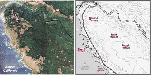
Figure 6. An orthophotograph and topographic representation of the Santa Cruz County marine terraces near Davenport, California. Note that the terraces here are dissimilar in dimension and spacing where coastal erosion and weathering is causing rapid clii face retreat across the first terrace. Third and fourth terraces are markedly smaller although are estimated to have been exposed 80 K year less. Jenny’s (Citation1973) wave-cut platform and offshore stacks, arches, tombolos, and skerries represent his “zero” terrace. Image by Google Earth and map by T.R. Paradise.
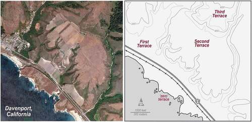
Figure 7. Graph and table representing the estimated ages of the marine terraces in Mendocino and Santa Cruz counties, California as a function of elevation. These findings were based on pedogenic analyses of iron and aluminum (Merritts & Bull, Citation1989) and cosmogenic radionuclide examination (Perg et al., Citation2001). Note that the Mendocino terraces are significantly older (c. 20k-80 K years) and higher (3rd terrace from 600ʹ-800ʹ) than the Santa Cruz terraces (3rd terrace at 400ʹ-600ʹ). Graphics by T.R. Paradise, after Merritts and Bull (Citation1989) and Perg et al. (Citation2001)
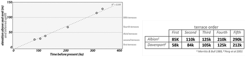
Figure 8. Image looking south in Mendocino County (from Albion to Elk, CA) at the sea stacks and wave-cut platforms on the “zero” terrace. The white structure sits atop the first terrace, and the second and third terraces are visible to the east. The relatively level mountain top to the left/east represents a fourth terrace in this area. Image by T.R. Paradise.
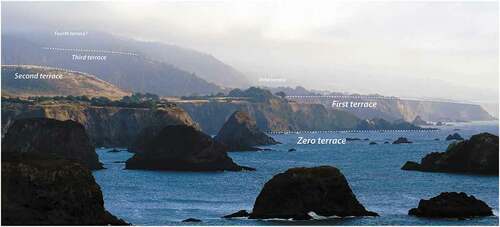
Figure 9. Image looking east, near Davenport, California (Santa Cruz County) showing the location and tiered sequence of the zero through fourth terraces. Note that the first and second terraces are used widely in the area for occupation and agriculture, while the third and fourth terraces are often forested and somewhat inaccessible. Fifth Terraces are often difficult to identify and observe since their greater exposure and increased weathering and erosion has altered their relatively flat morphologies and stair-step appearance. https://commons.wikimedia.org/wiki/File:Marine_terraces_California.jpg.
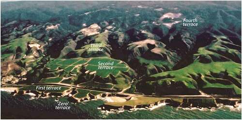
Figure 10. Different mushroom rocks from around the world. a) Roca Seta, a sandstone mushroom rock along the west coast of Galiano Island, British Columbia, Canada. ~2 m in height. Source: used under creative commons from https://commons.wikimedia.org/wiki/File:Roca_Seta.JPG, photograph by Arrecifazo. b) Limestone mushroom rocks at Yehliu Geopark, Taiwan. Varying sizes from <1 m to >3 m heights. Source: used under creative commons license: https://commons.wikimedia.org/wiki/File:1_yehliu_2015_panorama.jpg. c) Limestone mushroom rocks next to Aoshima Island near Miyazaki, Japan (Kyushu), ~1-1.5 m in height. A tombolo formed on raised and tilted limestone, Aoshima island is also known as the “Ogre’s Washboard” or “Devil’s Washboard”. Photograph by C.D. Allen, Citation2019. d) Kannesteinen Rock off the coast of Vågsøy, Norway. Eclogite (gneiss), ~3 m at its tallest and ~3 m at its widest. Source: used under creative commons license: https://commons.wikimedia.org/wiki/File:Kannesteinen_Rock_Nordfjord.jpg.
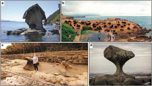
Figure 11. Map representing the main geologic divisions with mushroom rock locations on Barbados. An uplifted accretionary prism of turbidite, (mostly coral) limestone, and various sandstones, resulted in four main regions: current beaches/coasts (dated to ~82,000 ya), first high-cliff (dated to ~125,000 ya), the second high cliff (~640,000 ya at Mt. Hillaby), and the Scotland District (mixed rocks of mixed ages, mostly non-limestone groups, basement rocks formed in deep ocean ~44 mya), see Schellmann and Radtke (Citation2004), Schellmann et al. (Citation2004), Radtke and Schellmann (Citation2005), and Radtke and Schellmann (Citation2006), and Limonta et al. (Citation2015). Map by K.M. Groom.
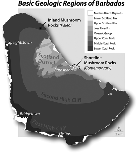
Figure 12. Mushroom rocks along Barbados east coast: a) large mushroom rock just 20 meters down the hill from Dina’s Bar next to Bathsheba Park, and b) Looking northwest along Long Beach, just south of Bathsheba with many mushroom rocks visible along the shore. Photographs by C.D. Allen, 2018.
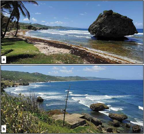
Figure 13. North aspect (a1) and its measurements (a2), West aspect (b1) and its measurements (b2), and Southwest aspect (c1) and its measurements (c2) of representative contemporary mushroom rock at Bathsheba, Barbados. Photographs by C.D. Allen, 2018. Measurement graphics by K.M. Groom.
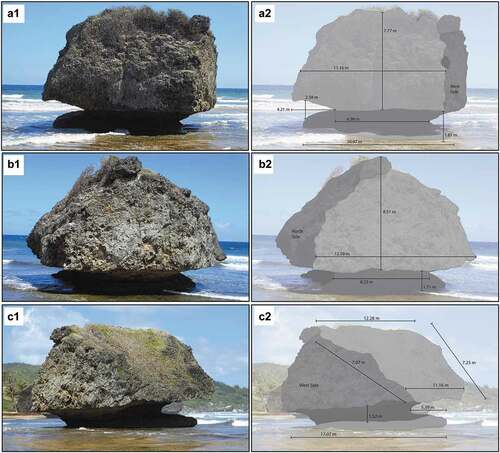
Figure 14. North-northwest aspect (a1) and its measurement (a2), southeast aspect (b1) and its measurement (b2), and west aspect (c1) and its measurments (c2) of paleo-mushroom rock in St. Lucy Parish, Barbados. See for location. Photographs by C.D. Allen, 2018. Measurement graphics by K.M. Groom.
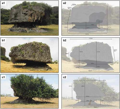
Figure 15. An aerial image showing confirmed inland mushroom rock (“Paleo Mushroom Rock”) and two “Potential Paleo Mushroom Rocks”, with distance from confirmed paleo-mushroom rock to current shoreline. Note the beginning of the Second High Cliff directly south of, and approximately 20 meters higher, than the inland mushroom rocks, which presumably represents the mushroom rocks’ source (i.e., from a rockfall/topple mass wasting event), as the entire land area to the north and east of the Second High Cliff is a wave-cut platform dated to ~125,000 years ago (cf., Cook & Abbott, Citation2011; Radtke & Schellmann, Citation2005, Citation2006; Schellmann & Radtke, Citation2004; Schellmann et al., Citation2004). Image source: Google Earth. Map by K.M. Groom.
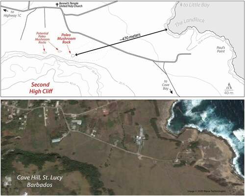
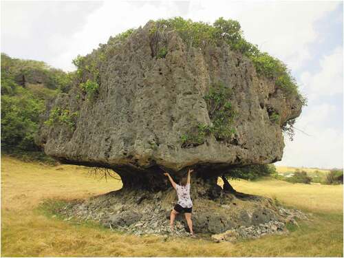
Figure 16. The confirmed inland tidal/wave-cut notch rock (“mushroom rock”) in St. Lucy Parish. This rock would have fallen from the Second High Cliff, perhaps more than 20 m up, just behind it, much like the current coastal mushroom rocks along Long Beach and Bathsheba (see ). The person in the image, roughly 1.5 m in height, is demonstrating the paleo wave-action that, alongside bioerosive processes that include algae-eating invertebrates, helped create this mushroom rock over many centuries. Looking at the underside of this section, clearly etched wave-cut patterns can be seen that line-up azimuthally with the ocean, and where the waves would have crashed into this rock. In other words, wave direction remains clearly visible on this section of the rock. Photograph by C.D. Allen, 2018.