Figures & data
Figure 1 Oblique aerial photo looking north along the Wellington Peninsula and harbour, and map of the Wellington Peninsula with place names referred to by Dieffenbach (1843) (photo: DL Homer, GNS Science).
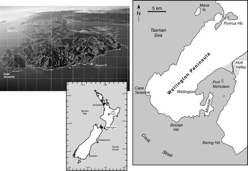
Figure 2 Photographs of Wellington-based geologists. Upper: left, James Coutts Crawford (1817–1889), Wellington Provincial Geologist (1861–1864) (photographer George Popowitz, 1849–1856; No. PA10–08–01, Crawford Family Collection, Alexander Turnbull Library, National Library of New Zealand); right, Alexander McKay (1841–1906), Assistant geologist, New Zealand Geological Survey (1873–1892) (Cyclopedia of New Zealand (Wellington Provincial District) 1897, Wellington, Cyclopedia Company Limited); Lower: left, Sir James Hector (1834–1907), Director of New Zealand Geological Survey (1865–1892) (photographed from framed photo; Institute of Geological and Nuclear Sciences Ltd.); right, James Abbott Mackintosh Bell (1877–1934), Director of New Zealand Geological Survey (1905–1911) (photographed from framed photo; Institute of Geological and Nuclear Sciences Ltd.).
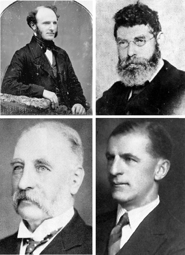
Figure 3 First geological map of the Wellington Peninsula (reproduced from Crawford 1864a; Geological Sketch Map of the Province of Wellington). Dashed lines = roads; hill heights in feet. Geology along the Line of Section is shown in . Scale and North direction are inserted.
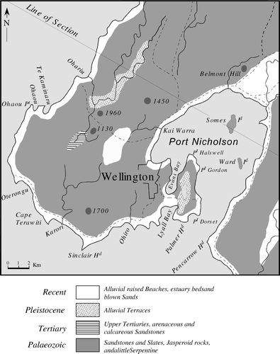
Figure 4 Cook Strait coastal sections of the Wellington Peninsula after Crawford (1864a) (south Wellington coastal section between Cape Terawhiti and Sinclair Head projected onto the section line shown in ) and McKay (1879a), compared with that of Suneson (Citation1993).
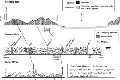
Table 1 Age and lithologic divisions of the Wellington greywacke
Figure 5 Map showing lithological and age divisions of the Wellington greywacke (after McKay 1879a,b; 1888). Localities of fossil plants from Crawford (1864b, 1869b) and McKay (1879a). ‘C’ = section at Pauatahanui Inlet where plant fossils were first found by Crawford in 1863. Localities of Torlessia mackayi from McKay (1879a,b, 1894). Distribution of semischistose greywacke (=?Devonian—Lower Carboniferous rocks of McKay 1879a) is after Begg and Mazengarb (Citation1996).
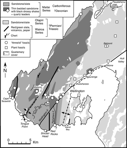
Figure 6 A, Schistose greywacke regarded by Crawford (1868), Hector (1869) and MacKay (1879a,b) as the oldest greywacke (Devonian?—Lower Carboniferous) of the Wellington Peninsula. Wrights Hill car park, Karori (Photo: S Eagar). B, Tube fossils of Torlessia mackayi preserved on a bedding plane in dark grey argillite from Sinclair Head, and probably the same locality mentioned by McKay (1879a). Greywacke containing the tube fossils was regarded as Carboniferous by McKay (1879b), but is now considered to be Triassic (photo: John Simes, GNS Science).
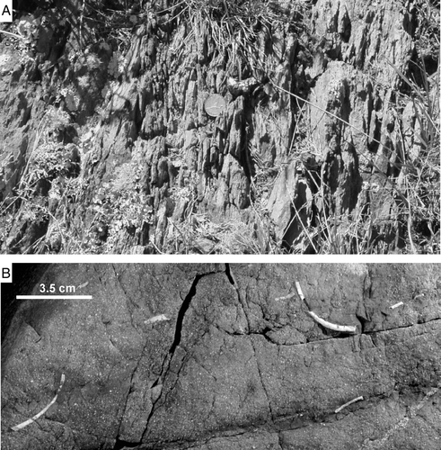
Figure 7 McKay's (1888b) section at Red Rocks compared with that of Broadgate (1916; cliff exposure), Wellman (Citation1949) and Grapes et al. (Citation1990); shore platform section).
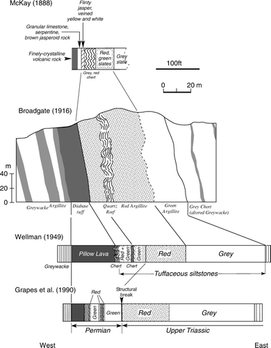
Figure 8 Map showing the remnant peneplain surface of the Wellington Peninsula (after Ota et al. Citation1981; Begg and Mazengarb Citation1996), cross sections (a and b) and faults from Bell (Citation1910).
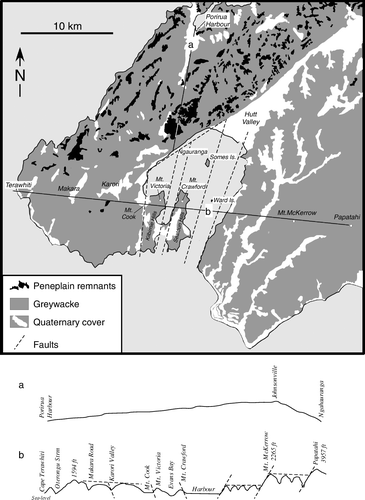
Figure 9 A, Oblique aerial photo looking north-east across the central part of the Wellington Peninsula (Port Nicholson in background) showing flattened hill tops of N–S trending ridges that represent remnants of the peneplain surface (photo: DL Homer, GNS Science). B, Photo showing solifluxion material exposed at Belmont. Such deposits contained the ‘travelled boulders’ described by Crawford in 1869a (photo: R Grapes).
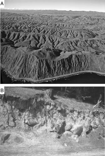
Figure 10 Map showing the distribution of Pleistocene-Holocene sediments in the Wellington Peninsula and the Makara Pliocene rocks (after Begg and Johnston Citation2000). The A-B section is after Adkin (Citation1954).
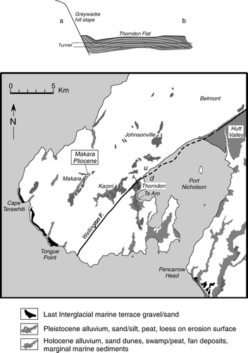
Figure 11 Map showing features relating to the idea of Port Nicholson being a freshwater lake (compiled from information given in Crawford 1874, 1875a,b). Distribution of greywacke and Quaternary sediments after Begg and Johnston Citation2000).
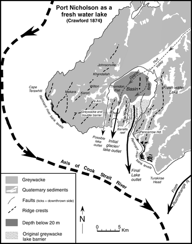
Figure 12 Coastal terraces preserved along the south coast of Wellington Peninsula, and first postulated by Crawford (1869b) as being of marine erosional origin and later, in 1874, as a possible remnant of a fluvial terrace that bordered a Cook Strait River. A, Terawhiti Hill (photo: CN 6921-1 by DL Homer, GNS Science). B, Tongue Point (photo: CN 21396-3 by DL Homer, GNS Science). See for localities.
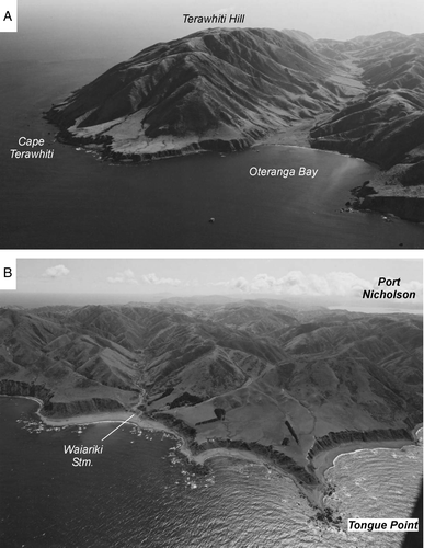
Figure 13 Map showing geology of Miramar peninsula and Kilbirine isthmus. Compiled from various sources; distribution of greywacke and Quaternary sediments (Begg and Mazengarb Citation1996); gravel bars, lake, lagoon, Pa site (Adkin Citation1959, Stevens 1974); uplifted 1855 beach (McKay 1879a; Bell Citation1910; Adkin Citation1955, 1956, 1957); Maori ovens, moa remains, granite boulder (Crawford 1873; McLeod Citation1912). Amount of uplift during the 1855 earthquake is shown for Balley Rock (off Point Jerningham) and the Evans Bay exit of a tunnel excavated through greywacke by Crawford to drain the lake in Miramar Valley.
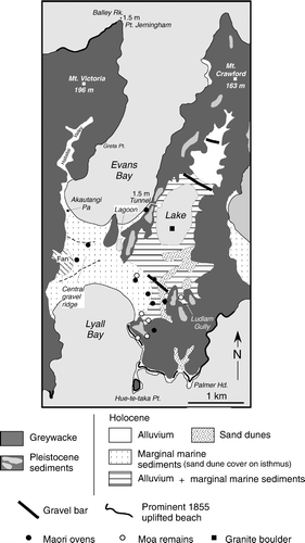
Figure 14 Map showing the distribution of faults (thick solid grey lines labeled 2, 3 and 4) in the Wellington Peninsula according to McKay (1892) and Bell (Citation1910) (solid thin black lines). Other named and unnamed faults shown are from Begg and Johnston (Citation2000).
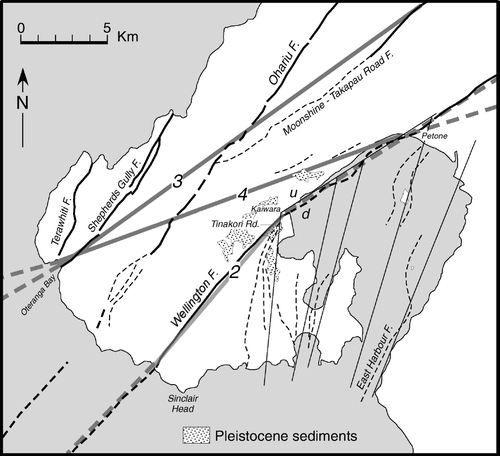
Figure 15 Map showing distribution of Pleistocene sediments, the Wellington Fault, Happy Valley Fault and associated faults, spot heights and localities (from Begg and Mazengarb Citation1996) to illustrate McKay's (1879a) postulated continuation of the Wellington Fault (thick dashed line) from Kaiwharawara to the south Wellington coast. See text.
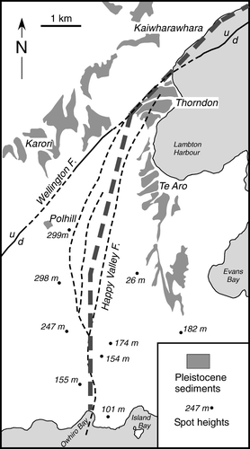
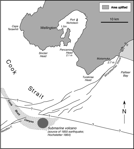
Figure 16 Map showing location of the Cook Strait ‘volcanic source’ of the 1855 earthquake inferred by Haast (Citation1862) and Hochstetter (1864).