Figures & data
Fig. 1. Guide to the Selden map of China (c.1619), with author's identification of the main political and cultural entities. The original, drawn in ink and watercolour on paper, measures approximately 158 × 96 cm (see Plate 5). Oxford, Bodleian Library, MS Selden Supra 105. (© R. Batchelor. Map reproduced with permission from The Bodleian Library.)
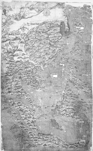
Fig. 2. on of selected inscriptions. The solid black dots indicate a labelled circle on the original; the open circles indicate islands that are labelled, but lack a circle. Oxford, Bodleian Library, MS Selden Supra 105. (© R. Batchelor. Map reproduced with permission from The Bodleian Library.)
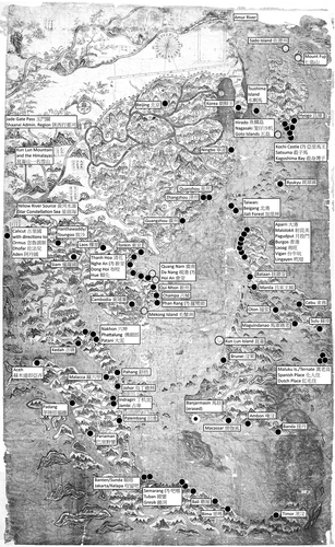
Fig. 3. The Selden map of China with shipping routes highlighted. The north–south line marks approximately the central axis of the map, which should pass through Beijing in the north and just off the Vietnam coast at Champa in the south (see ). Oxford, Bodleian Library, MS Selden Supra 105. (© R. Batchelor. Map reproduced with permission from The Bodleian Library.)
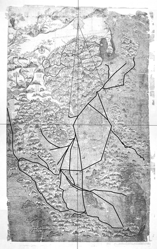
Fig. 4. Reverse of the Selden map of China, as revealed during restoration in 2010, with drafting marks highlighted. Oxford, Bodleian Library, MS Selden Supra 105. (© R. Batchelor. Map reproduced with permission from The Bodleian Library.)
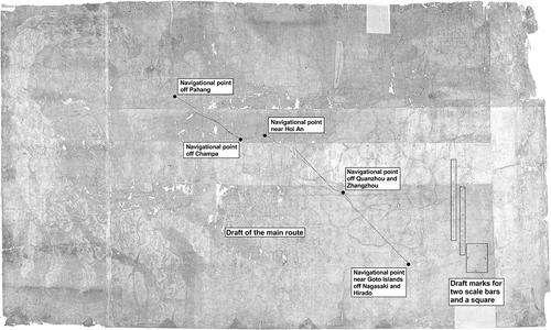
Fig. 5. Printed map of the Ming Empire entitled Ershiba xiu fenye huang Ming gesheng di yu zong tu (二十八宿分野皇明各省地輿總圖, ‘Twenty-eight mansion, field-allocation, imperial Ming, all provinces terrestrial world map’) from the popular Ming encyclopaedia, Bianyong Xuehai qunyu (便用學海群玉, ‘Convenient to use: Seas of knowledge, mines of jade’), revised by Wu Weizi (Fujian, Xiong Chongyu from Jianyang, 1607), juan 2. Approx. 22 × 24 cm. North is at the top. To the northwest and west the Great Wall is marked with double broken lines and towers. In the ocean to the east are Korea (朝鮮), Japan (日本) and Ryukyu (琉球). The gourd shape in the lower left is the Star Constellation Sea (星宿海, Xingxiu Hai). This sole surviving copy is in Leiden University, Acad. 226. (Reproduced with permission from the University of Leiden.)
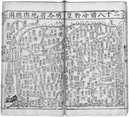
Fig. 6. Details from the western edge of the Selden map (left) and the same geographical area on the Ming encyclopaedia map (right). In addition to the addition on the Selden map of place-names for Burma and Siam, a box next to Calicut (古里国) gives instructions for reaching Aden (阿丹国), Zufar/Salalah (法兒国) and Ormuz (忽魯謨斯). The most important change is the transformation of the mythical Star Constellation Sea, the source of the Yellow River on both maps, into a bulbous Indian Sea on the Selden map. Inscriptions 1 to 8 are virtually identical on both maps, but Calicut (9) is not marked on the Ming map. A and B are examples of the copying of inscriptions in the western part of the province of Shaanxi (陜西). Oxford, Bodleian Library, MS Selden Supra 105; Leiden University, Acad. 226. (Reproduced with permission from The Bodleian Library and University of Leiden respectively.) (1) 玉門關, Yumen Guan, Jade Gate Pass; (2) 陝西行都司, Shaanxi xing dusi, Shaanxi Administrative Region; (3) 崑崙山, Kunlun Shan, Kunlun Mountain; and一名雪山, Yiming Xueshan, The Himalayas (?): Lit. ‘All snow-capped mountains’ (the Selden map adds the magical grain tree known as muhe (木禾), depicted here as a Chinese white pine, a source of pine nuts); (4) 河州, Hezhou; (5) 馬湖府西至黃河三千里, Mahu fu xi Huang He san qianli, Mahu west of Yellow River, three thousand li; (6) 麗河西北至黃河一千五百里, Li He xibei zhi Huang He, Li River northwest of Yellow River, one thousand five-hundred li; (7) 黃河水源, Huang He shuiyuan, source of the Yellow River (the Selden Map adds shui to emphasize that this is a terrestrial river rather than a cosmological connection); (8) 星宿海, Xingxiu Hai, Star Constellation Sea (note the shift from a constellation map to circles indicating islands); (9) 古里国, galiguo, Calicut. In Shaanxi (陝西) Province: (A) 臨洮, Lintao, and 鞏昌, Gongchang (in yellow circles on the Selden map); (B) Fenye markings for the constellations gui (鬼, ghost), bi (壁, wall) and jing (井, well) (in red circles on the Selden map).
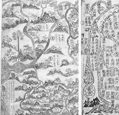
Fig. 7. Selden map of China. Detail showing Fujian, Taiwan and the navigational point off Fujian near (1) Quanzhou (泉州) and (2) Zhangzhou (漳州 ). Also visible are (3) the Penghu Islands (彭島), (4) Pratas Island and Reef (南澳氣 ), and (6) the Eastern Sea (東海). Between Taiwan and Luzon (5) the caption reading 此門流水東甚緊, ci men liushui dong shen jin, ‘This passage, flowing east, extremely tight’, indicates the beginning of the Kuroshio current. Oxford, Bodleian Library, MS Selden Supra 105. (Reproduced with permission from The Bodleian Library.)
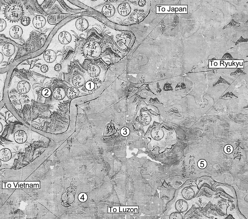
Fig. 8. Southern Japan on the Selden map of China. The red chrysanthemums near ‘fish-scale island’ (Hyogo/Firando) are unique on the map. The western (left) mercantile trunk route goes to Fujian and Vietnam. The eastern route is the traditional tributary route, dating back to the fifteenth century, from Fujian to Ryukyu to Hyogo. Oxford, Bodleian Library, MS Selden Supra 105. (Map reproduced with permission from The Bodleian Library.) (1) 兵庫, Hyogo (in Japanese): the port receiving early Ming embassies; (2) 亞里馬王, Yalima wang, possibly Shikoku Island or Kochi Castle; (3) 殺身灣子, Shashen wanzi, Kagoshima Bay; (4) 殺子馬, Shazima, Satsuma; (5) 笼仔沙机, Languesaque, transliteration of the Portuguese ‘Languesaque’ or Nagasaki; (6) 魚鱗島, Yulin dao, lit. ‘fish-scale island’ for Hirado (Firando); (7) 衣戈, Yige, Iki Island; (8) 五島, Wu dao, the five islands or Goto Islands: same characters and meaning in Japanese; (9) 天堂, Tiantang, lit. ‘paradise’, translation of Amakusa Islands (天草, Heaven's Grass); (10) 野故門水流東甚緊, Yegu men shuiliu dong shen jin, 'Yegu passage, eastward current, very tight’ (eastward current, indicating the Kuroshio current).
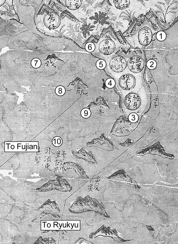
Fig. 9. Left: detail from the Selden map of China showing the Paracel and Spratley islands, accompanied respectively by the mimetic form of a ‘sail’ and a ‘snake with veins’. Oxford, Bodleian Library, MS Selden Supra 105. (Map reproduced with permission from The Bodleian Library.) Right: The Paracels and Spratley islands from and (top and bottom respectively). In both these cases, the ‘sail’ and the ‘snake’ elements have been merged. (Maps reproduced with permission from the Hong Kong University of Science and Technology Library, Hong Kong, and the British Library, London, respectively.) (1) 萬里長沙似船帆樣, Wanli changsha si chuanfan yang, ‘The Paracel islands (10,000 isles) resembling the shape of a sail.’ The Wanli changsha are generally accepted to be the Paracels; (2) 嶼紅色, Yu Hongse, Red Islands, probably a transliteration of the Vietnamese term for the Paracels, Hoang Se (lit. ‘Yellow Sands’); (3) 萬里石塘, Wanli shitang, the Spratleys (?). This attribution from the texts of the period is today an issue of international sovereignty. The large cluster above the circle is filled with red dots, suggesting a connection with the adjacent inscription Hongse; (4) 在峴港, Da Nang Peninsula; and會安, Hoi An. The unidentified island is possibly Cù-lao Chàm. The inscriptions are difficult to read; (5) 里柬 (?), for the eastern-most island. Possibly Con Dao (west) and Cuo Lao Thu (east). The inscriptions are difficult to read; (6) 毛蟹洲, Maoxie zhou, Mekong Island; (7) 廣南 Guangnam, Quang Nam.
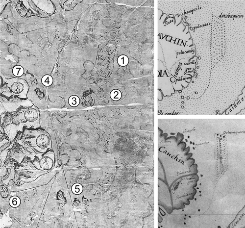
Fig. 10. Copperplate map of East Asia entitled Sinarum Regni aliorumque regnorum et insularum illi adiacentium descriptio., c.1597–1609. 47 × 35 cm. The undated and anonymous map was copied and printed from a now-lost Spanish draft that had recently arrived in Spain, probably from Manila, that had been completed in Madrid by 1609. The cartouche, which contains information taken from a Ming census gives the number of administrative divisions for each province and concludes: ‘in toto Sinarum Regno su 156 ceu, 235 Hhien, 1154 huy, zii su vero 213’. Note the ‘sail’ of the Paracels (see ). Hong Kong University of Science and Technology, G7400 1590.S54. (Map reproduced with permission from Hong Kong University of Science and Technology Library, Hong Kong.)
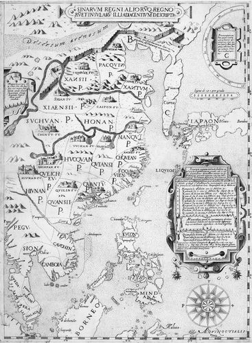
Fig. 11. Manuscript copy, made in Madrid in 1609 for the English envoy Charles Cornwallis, of the Spanish map of East Asia (see ). The shorter English version of the inscription notes that ‘The Kingdom of China’ has ‘150 great Cittes, 235 small ones, 1154 townes, villages decayed 211, forts of guard 213’. This map shows more to the south than the printed version and includes the whole of Borneo and the Malukus. Note the ‘sail’ of the Paracels (see ). British Library, Cotton Augustus, II.ii.45. (Map reproduced with permission from the British Library.)
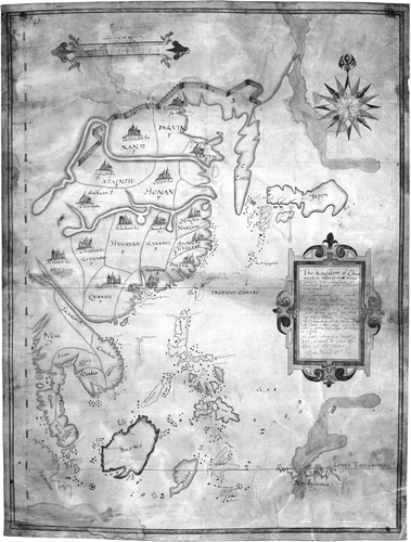
Plate 5. The recently rediscovered Selden map of China (c.1619). Ink and watercolour on paper. Approx. 158 × 96 cm. Its outstanding feature is the system of shipping routes and emphasis on ports in Southeast Asia, from Japan to Sumatra, that bound the region’s mountainous hinterlands and littorals together through trade. Oxford, Bodleian Library, MS Selden Supra 105. (Reproduced with permission from The Bodleian Library.) See pages 37, 97.
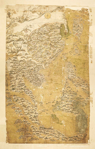
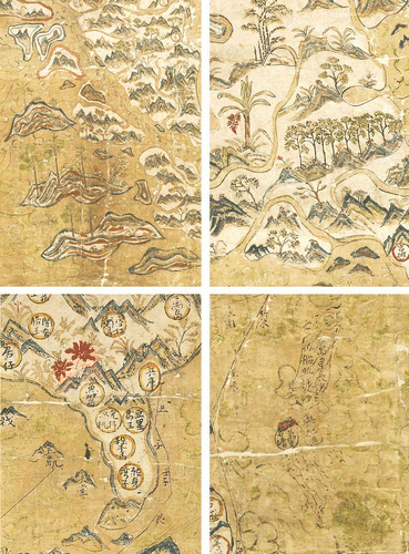
Plate 6. Details from the Selden map of China to show the map’s ‘painterly’ style and the realistic portrayal of vegetation. Top left: palms on the islands west of Sumatra. Top right: a row of eight aquilaria trees, suggestive of a plantation, with a red banana tree. Bottom left: Japan, with the two red chrysanthemums that stand out prominently on the map (see Batchelor, Figure 8). Bottom right: the Paracel and Spratley islands with, between them, the island, touched up in red, that served as the datum point in the map’s construction. Oxford, Bodleian Library, MS Selden Supra 105. (Reproduced with permission from The Bodleian Library). See pages 50, 51, 52 (Batchelor) and 100 (Davies).