Figures & data
Fig. 1. Location of area shown in Henri Coudreau’s map of the contested Franco–Brazil frontier. (Drawn by D. Bove.)

Fig. 2. Carte générale de la Guyane représentant les prétentions des deux parties et dressée principalement d’après les cartes annexées aux documents français et brésiliens (1900). 41 × 32 cm. Scale 1:4,000,000. The map shows the rival claims. Brazil wanted the border to run along the river Oyapoc [Oyapock] and thence across French Guinea [Guyane française] to the Tumuc Humac mountains, which border Dutch Guiana (see detail in ). France claimed all the land between that line, extended west to the Rio Branco, and a second line running from the Branco to the Rio Araguay and the Atlantic Ocean. The map was published as Plate 1 in the official proceedings of the Swiss arbitration, Sentence du Conseil fédéral suisse dans la question des frontières de la Guyane française et du Brésil du 1er décembre 1900 (Bern, Imprimerie Staempfli, 1900), Annexes. Bibliothèque de Genève, Département de Cartes et Plans, tiroir Amérique latine—cartes partielles. (Reproduced with permission from the Bibliothèque de Genève, Switzerland.)
![Fig. 2. Carte générale de la Guyane représentant les prétentions des deux parties et dressée principalement d’après les cartes annexées aux documents français et brésiliens (1900). 41 × 32 cm. Scale 1:4,000,000. The map shows the rival claims. Brazil wanted the border to run along the river Oyapoc [Oyapock] and thence across French Guinea [Guyane française] to the Tumuc Humac mountains, which border Dutch Guiana (see detail in Figure 3). France claimed all the land between that line, extended west to the Rio Branco, and a second line running from the Branco to the Rio Araguay and the Atlantic Ocean. The map was published as Plate 1 in the official proceedings of the Swiss arbitration, Sentence du Conseil fédéral suisse dans la question des frontières de la Guyane française et du Brésil du 1er décembre 1900 (Bern, Imprimerie Staempfli, 1900), Annexes. Bibliothèque de Genève, Département de Cartes et Plans, tiroir Amérique latine—cartes partielles. (Reproduced with permission from the Bibliothèque de Genève, Switzerland.)](/cms/asset/48261430-b260-4d0d-84f1-00eedaa20178/rimu_a_1027554_f0002_b.gif)
Fig. 3. Detail from the Carte générale de la Guyane (see ). The single-headed arrow points to Brazil’s claim, eventually favoured, for a boundary along the Oyapock River and thence along the watershed of the Amazon basin to the border with Dutch Guiana. The double-headed arrow indicates part of the area wanted by France. From Sentence du Conseil fédéral suisse dans la question des frontières de la Guyane française et du Brésil du 1er décembre 1900 (Bern, Imprimerie Staempfli, 1900), Annexes, Plate 1. Bibliothèque de Genève, Département de Cartes et Plans, tiroir Amérique latine—cartes partielles. (Reproduced with permission from the Bibliothèque de Genève, Switzerland.)
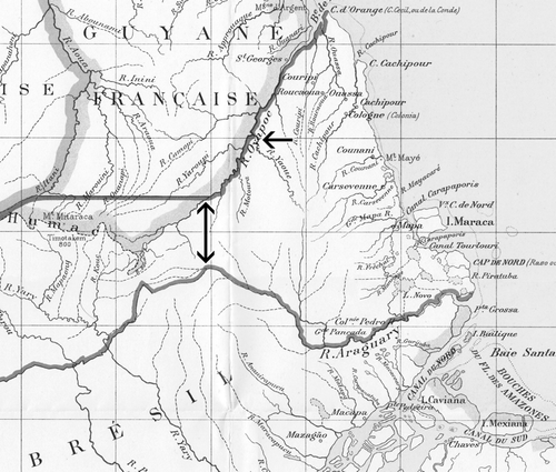
Fig. 4. Henri Coudreau’s manuscript map of Guiana, of 1893 (see Plate 9). Manuscript. 85 × 60 cm. Scale 1:312,500. The key lists the signs for settlements, paths and vegetation, but most of the written notes on the map concern aspects of the region’s hydrography. At issue in the dispute over the Franco-Brazilian frontier was the Carapaporis channel between Maraca Island and the mainland, which the French alleged had been created only recently and thus marked the frontier as this had been established in the Utrecht agreement of 1713, before the island was cut off. Bibliothèque de Genève, Département de Cartes et Plans, tiroir Amérique latine—cartes partielles. (Reproduced with permission from the Bibliothèque de Genève, Switzerland.)
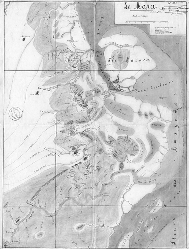
Plate 9. Le Mapa, Henri Coudreau’s unpublished map of Guiana given to Élisée Reclus in 1893 for the Nouvelle Géographie universelle (vol. 19, Hachette, 1894). 85 × 60 cm. Scale 1: 312,500. North is at the top. The map contains a wealth of detail about the physical geography of the part of the coast of Brazil from the Amazon’s northern channel to the Carsevenne River that was being claimed by France. Bibliothèque de Genève, Département de Cartes et Plans, tiroir Amérique latine—cartes partielles. (Reproduced with permission from the Bibliothèque de Genève.) See p. 232.
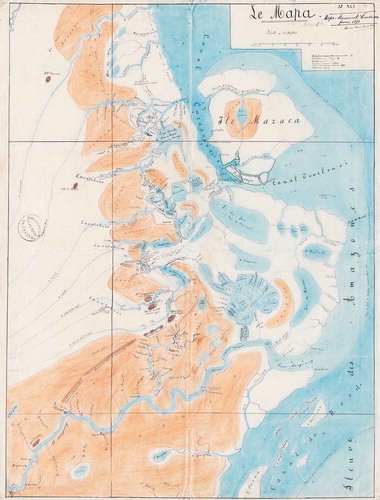
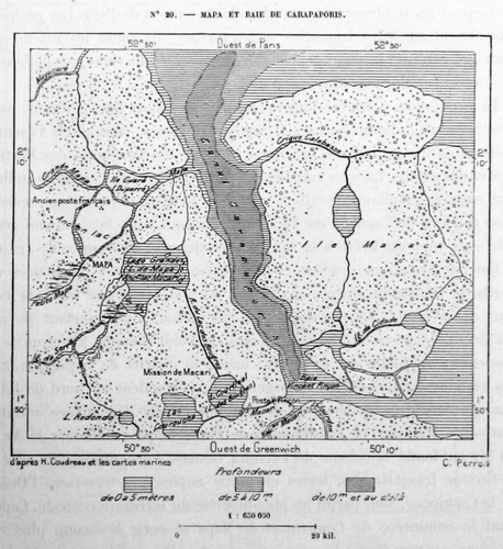
Fig. 5. Detail from Coudreau’s map as redrawn by Charles Perron for the Nouvelle Géographie universelle, volume 19, 1894, 87, showing the deep-water Carapaporis channel and Maraca Island. The stippling represents marshy zones. (Reproduced with permission from the Bibliothèque de Genève, Switzerland.)