Figures & data
Figure 1 Canadian Prairie Provinces with the four selected study sites (Banff, Calgary, Saskatoon and Winnipeg), overlain by National Centers for Environmental Prediction (NCEP; black diamonds) and Canadian Global Climate Model (CGCM; grey circles with black centres) grid cells. Inset shows the location of the study area in North America.
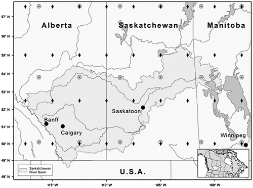
Table 1. Information about meteorological stations used in the study.
Figure 2 Boxplots of annual (January to December) and winter (December, January and February), spring (March, April and May), summer (June, July and August) and autumn (September, October and November) precipitation observed at Banff, Calgary, Saskatoon and Winnipeg. The boxes correspond to the interquartile range (IQR), the line in the middle of the box to the median value and the whiskers to either the maximum value or to 1.5 times the IQR. Outliers that lie outside the 1.5 times IQR range are shown using circles.
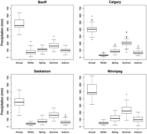
Table 2. Identified Generalized Linear Model-based weather generator (GLM-WG) structures for four studied sites. I[Y(t–1)>0] is an indicator function for precipitation occurrence on previous day. ln[1+Y(t–1)] represents log transformed previous day precipitation.
Figure 3 Quantile-quantile (Q-Q) plots of observed and simulated daily precipitation for the (a) calibration and (b) verification periods. Diagonal line represents perfect match. LARS-WG is the Long Ashton Research Station weather generator, and GLM-WG is the Generalized Linear Model-based weather generator.
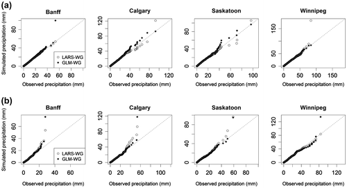
Figure 4 Comparison of observed (solid lines) and ensemble averaged simulated (small dashed lines) values of mean, variance, first autocorrelation and proportion of dry days (PDD) derived from daily precipitation sequences for Saskatoon for the calibration period. Upper and lower large dashed lines correspond to 2.5th and 97.5th quantiles, respectively. LARS-WG is the Long Ashton Research Station weather generator, and GLM-WG is the Generalized Linear Model-based weather generator.
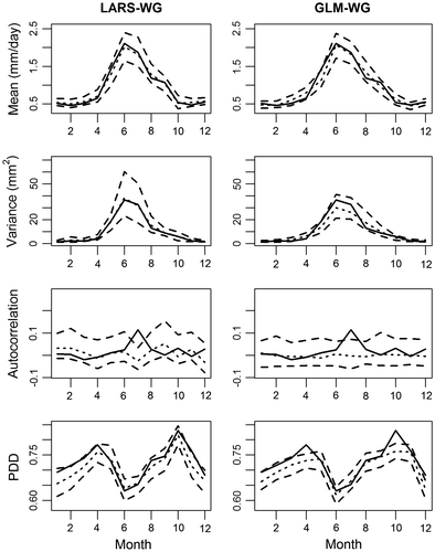
Figure 5 Comparison of observed (solid lines) and ensemble averaged simulated (small dashed lines) values of mean, variance, first autocorrelation and proportion of dry days (PDD) derived from daily precipitation sequences for Saskatoon for the verification period. Upper and lower large dashed lines correspond to 2.5th and 97.5th quantiles, respectively. LARS-WG is the Long Ashton Research Station weather generator, and GLM-WG is the Generalized Linear Model-based weather generator.
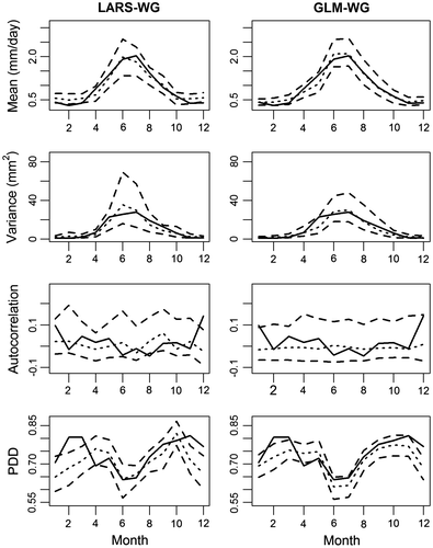
Figure 6 Comparison of observed (solid lines) and ensemble averaged simulated (small dashed lines) values of mean and variance of monthly precipitation for Saskatoon for the (a) calibration and (b) verification periods. Upper and lower large dashed lines correspond to 2.5th and 97.5th quantiles, respectively. LARS-WG is the Long Ashton Research Station weather generator, and GLM-WG is the Generalized Linear Model-based weather generator.
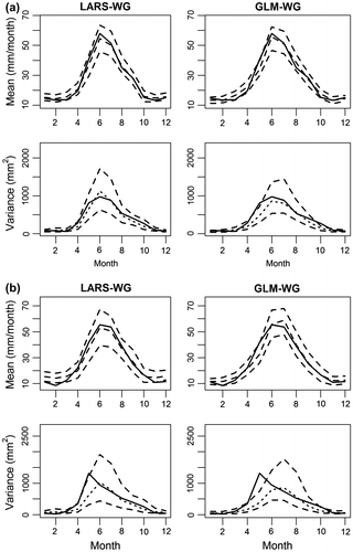
Figure 7 Observed (black dots) and ensemble averaged simulated (grey dots) mean annual precipitation along with the 95% confidence bands derived from 100 simulated precipitation series. LARS-WG is the Long Ashton Research Station weather generator, and GLM-WG is the Generalized Linear Model-based weather generator.
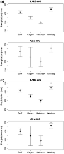
Figure 8 Gumbel probability plots of observed (black dots) and ensemble averaged simulated (grey lines) annual daily precipitation extremes for the (a) calibration and (b) verification periods. Upper and lower dashed lines correspond to 2.5th and 97.5th simulated quantiles, respectively. LARS-WG is the Long Ashton Research Station weather generator, and GLM-WG is the Generalized Linear Model-based weather generator.
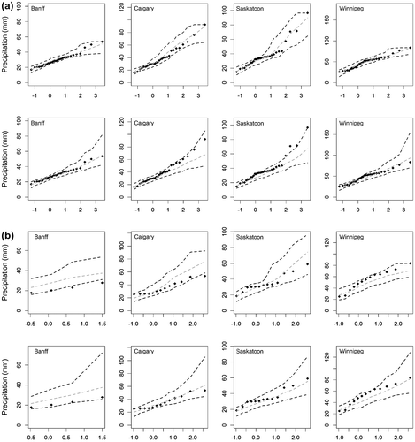
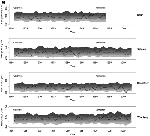
Figure 10 Plots of observed and simulated values of Drought Severity Index (DSI3) for droughts lasting for at least 3 months at Saskatoon. Greyscale bands (from light to dark grey) correspond to 0–5, 5-25, 25–50, 75–95 and 95–100th quantiles intervals derived from the simulated ensemble. LARS-WG is the Long Ashton Research Station weather generator, and GLM-WG is the Generalized Linear Model-based weather generator.
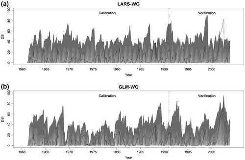
Figure 11 Probability density functions of the standardized large-scale climate variables (SLP, T and RH) derived from Canadian Global Climate Model (CGCM) outputs for current (1961–1990) (grey solid lines) and future (2071–2100) (grey dashed lines) periods. Probability density functions of the same variables derived from National Centers for Environmental Prediction (NCEP) reanalysis data (black lines) for the current (1961–1990) period are also shown. Plots from the first to fourth rows correspond to Banff, Calgary, Saskatoon and Winnipeg, respectively.
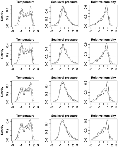
Figure 12 Downscaled annual precipitation for 2080s using the Long Ashton Research Station weather generator (LARS-WG) and the Generalized Linear Model-based weather generator (GLM-WG) for Saskatoon. Greyscale bands (from light to dark grey) correspond to 0–5, 5–25, 25–50, 50–75 and 95–100th quantile intervals of the simulated ensemble.
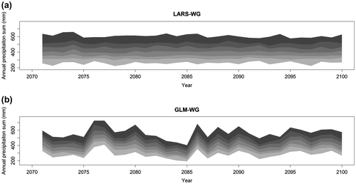
Figure 13 Boxplots of 5-, 10-, 30- and 50-year return levels of annual daily precipitation extremes for the 1961–1990 current (white box) and 2071–2100 future (grey box) periods for the Long Ashton Research Station weather generator (LARS-WG; left four panels) and Generalized Linear Model-based weather generator (GLM-WG; right four panels). Statistically significant (insignificant) differences in return levels are shown in black (grey). The boxes correspond to the interquartile range (IQR), the line in the middle of the box to the median value and the whiskers to either the maximum value or to 1.5 times the IQR. Outliers that lie outside the 1.5 times IQR range are shown using circles.
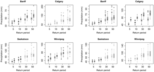
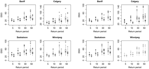
Figure 14 Boxplots of 5-, 10-, 30- and 50-year return levels of annual maximum Drought Severity Index (DSI3) for droughts lasting for at least 3 months for the 1961–1990 current (white box) and 2071–2100 future (grey box) periods for the Long Ashton Research Station weather generator (LARS-WG; left four panels) and Generalized Linear Model-based weather generator (GLM-WG; right four panels). Statistically significant (insignificant) differences in return levels of drought indices are shown in black (grey). The boxes correspond to the interquartile range (IQR), the line in the middle of the box to the median value and the whiskers to either the maximum value or to 1.5 times the IQR. Outliers that lie outside the 1.5 times IQR range are shown using circles.