
Figures & data
Figure 1. (a) Chaudière River watershed with a digital elevation model as background. The Appalachian Piedmont extends northward and the Appalachian Uplands southward from the marine limit. Locations of major municipalities are indicated with white circles; surface water bodies are shown (the same applies for the following figure parts). (b) Simplified tectonostratigraphic units (modified from Slivitzky and St-Julien Citation1987). (c) Simplified Quaternary geology (modified from Caron Citation2012). (d) Regional potentiometric surface. Black dots indicate measured groundwater levels.
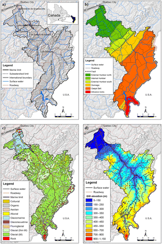
Figure 2. Statistical analysis of hydraulic conductivity values. The box extends from the lower (Q25%) to upper quartile (Q75%) with a median line; whiskers extend to the most extreme values within a range equal to 1.5 × (Q75% – Q25%); numbers in parentheses indicate the total number of data points per bedrock unit.
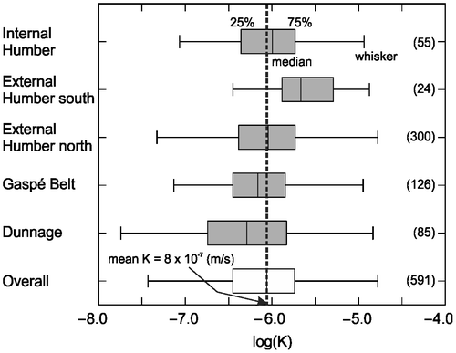
Table 1. Hydrogeologic properties of soil units used in recharge simulations.
Figure 3. Spatial distribution of the annual recharge rate predicted with the Hydrologic Evaluation of Landfill Performance (HELP) model, together with the locations of gauging and weather stations.
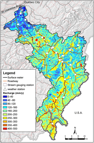
Table 2. Statistical information on chemical analyses of 155 groundwater samples collected in bedrock and surficial wells.
Figure 4. Water types in bedrock (n = 113) and surficial (n = 31) wells. Water samples from surficial wells are indicated with a black dot in the center. Ion concentrations are scaled to the observed total dissolved solids (TDS).
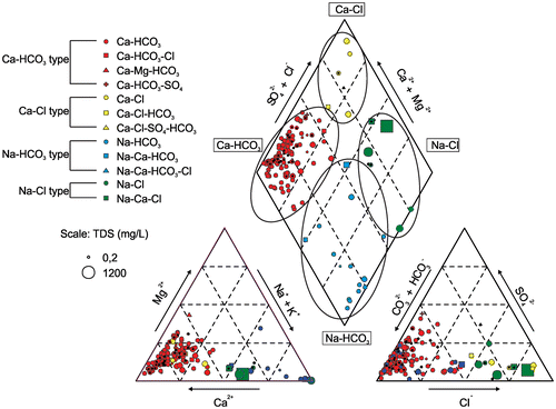
Figure 5. Spatial distribution of groundwater types, location of geochemical cross-section along with groundwater samples used for isotope analyses (indicated with numbers from 1 to 10), and location of precipitation gauges. Water samples from surficial wells are indicated with a black dot in the center. Numbers in parentheses indicate number of samples per water type (bedrock well, surficial well).
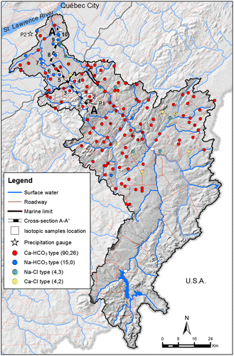
Figure 6. Relationship between bromine (Br) and chlorine (Cl) concentrations.
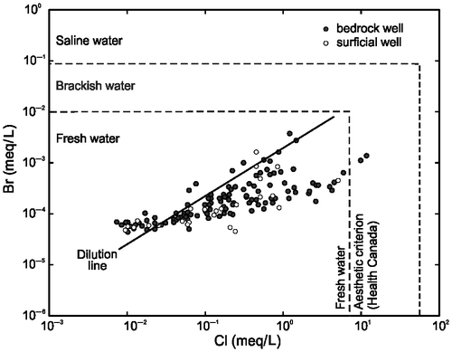
Figure 7. Isotopic signatures of the monthly precipitation water samples collected from the two stations [P1 at ~500 m above sea level (asl) and P2 at ~70 m asl] and 10 water samples from bedrock wells (indicated in Figure ). Straight lines indicate published meteoric water lines at the regional scale.
![Figure 7. Isotopic signatures of the monthly precipitation water samples collected from the two stations [P1 at ~500 m above sea level (asl) and P2 at ~70 m asl] and 10 water samples from bedrock wells (indicated in Figure 8). Straight lines indicate published meteoric water lines at the regional scale.](/cms/asset/20a8dd46-f98f-4dad-aa02-c489d4269a11/tcwr_a_881589_f0007_oc.gif)
Figure 8. (a) Conceptual groundwater flow model along a regional flowpath indicated with cross-section A–A’ in Figure . (b) Concentrations of major hydrochemical constituents. (c) Relationship between tritium and radiocarbon age. Linear regressions are given with bold lines.
