Figures & data
Figure 1. Location map. Elevation contours provided only for approximate visual reference; interval is ~600 m. Flat areas at east side of North American and west side of Scandinavian inset maps are the northern Great Plains and Norwegian Sea, respectively. Note differing scales for the two inset maps.
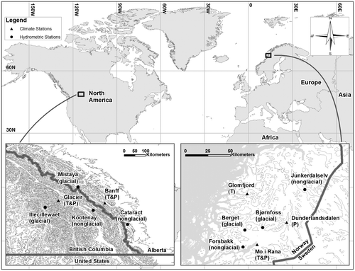
Table 1. Hydrometric and climate station summary. Elevations are given in meters above sea level (masl). MAT and TAP denote the averages, over the period of record used in the analyses, for mean annual air temperature and total annual precipitation, respectively.
Figure 2. Example of filtered daily data, over period of record used in the analysis, for data group N2. Data are presented as a raster hydrograph (e.g. Koehler Citation2013) or its meteorological equivalent. Horizontal-axis tick marks denote the start of every calendar month, beginning with 1 October (day of the hydrologic year, DOHY = 1); labels are provided for every third month. The figure shows ln(Q) and P1/2, where Q is streamflow (m3/s) and P is precipitation (mm). These transforms are used only to facilitate effective visual display, and analyses were conducted on non-transformed data. Temperature, T, is given in °C. Some gaps or uneven record lengths are present in the T and P data. Overall hydroclimatic regimes for the other three catchment pairs considered are generally similar (see text for details).
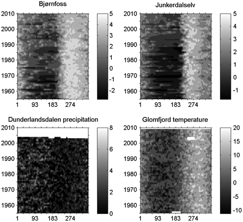
Figure 3. Example of monotonic trend analysis results (data group N2). Left column: Spearman rank correlation (correlation coefficient, and p-value). Right column: Akaike Information Criterion (AIC)-based polynomial selection (linear trend rate, and approximate probability that trend is present). Heavy box outlines late-summer to early-autumn period.
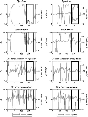
Figure 4. Annual (net) glacier mass balance for Engabreen (Scandinavian Mountains, Nordland, Norway) and Peyto (Rocky Mountains, Alberta, Canada). Dashed lines provide simple linear regression trends for reference.
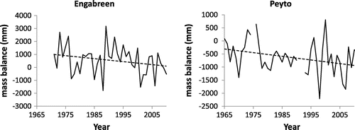
Figure 5. Example of teleconnection analysis results (data group C1, El Niño-Southern Oscillation, ENSO). Left column: Spearman rank correlation (correlation coefficient, and p-value). Right column: Akaike Information Criterion (AIC)-based polynomial selection (approximate probability of any teleconnection, and evidence ratio for a nonlinear relationship). Heavy box outlines late-summer to early-autumn period.
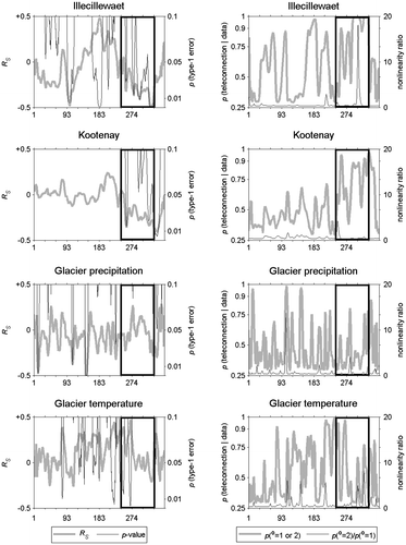
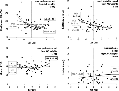
Figure 6. Example scatterplots for teleconnections between data group C1 and an El Niño-Southern Oscillation (ENSO) index (the Oceanic Niño Index, ONI). Results for early August are shown. M1, M2, and M3 correspond to 0th, 1st and 2nd degree polynomial models; these in turn reflect no-effect, linear teleconnection and nonlinear teleconnection outcomes, respectively. Corresponding correlation skills, R, for each model are also provided; values are generally modest, reflecting the fact that any given climate mode explains only some limited portion of year-to-year variability. The most likely model, using probability estimates based on Akaike weights formally balancing model performance against model parsimony, is noted in each case. For this particular example, nonlinear teleconnections are identified as the preferred model for air temperature and glacial river flows, whereas a non-glacial streamflow teleconnection is present but linear, and precipitation exhibits no statistically defensible relationship to the ONI.