Figures & data
Figure 1. (a) Location of the study area (Covey Hill Natural Laboratory). The Hemmingford (HMG) weather station is shown on the inset map; (b) regional cross-section. Note that the delineated “watershed limits” correspond to the gauging station watersheds. The Système d'information hydrogéologique (SIH) wells are not represented in this figure. Modified with permission from Levinson et al. (Citation2014b).
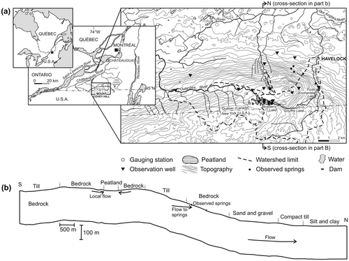
Table 1. RCM runs used for this study (see Mearns et al. Citation2012 for model acronym details).
Figure 2. The groundwater model domain with recharge and hydraulic conductivity zones (from Levison et al. Citation2014b). Recharge zone 1 covers the area of the peatland.
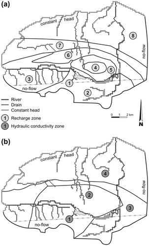
Figure 3. Comparison of Poirier et al. (Citation2014) data with measured data from the Hemmingford (HMG) weather station from 1961 to 2010: (a) monthly temperature, and (b) monthly precipitation. Error bars represent minimum and maximum monthly values over the 1961–2010 period. CEHQ = Centre d'expertise hydrique du Québec.
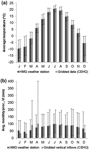
Figure 4. Annual vertical inflow (VI), evapotranspiration (PET), net precipitation (Pnet), Pnet 10-year moving average and temperature (T) from 1900 to 2010.
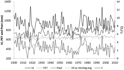
Figure 5. Annual recharge from 1900 to 2010 compared to (a) average simulated hydraulic heads for the study area, (b) average simulated spring flow and (c) average simulated baseflows for the Allen River, the Outardes River and the Schulman stream.
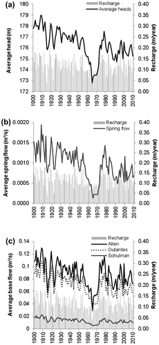
Table 2. Long-term trends for calculated recharge and for simulated heads, spring flows and river/stream baseflows.
Table 3. Groundwater flow simulations with climate change scenarios. Future projections for calculated recharge and for simulated heads, spring flows and river/stream baseflows.
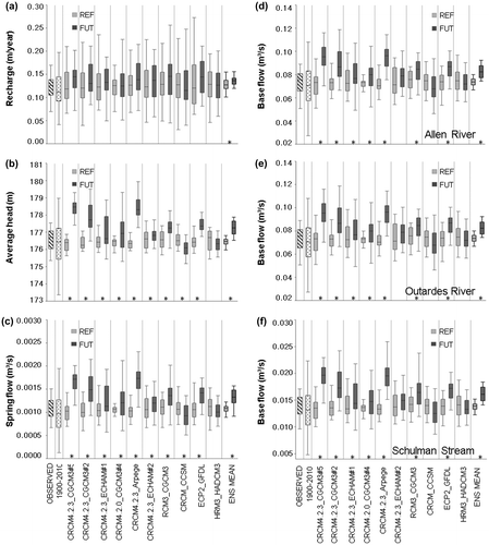
Figure 6. Comparison with climate change conditions for: (a) recharge, (b) average hydraulic heads, (c) total spring outflows, (d) baseflows to the Allen River, (e) baseflows to the Outardes River and (f) baseflows to the Schulman stream. The significant differences (Wilcoxon–Mann–Whitney test; α = 0.05) between the reference and future periods are marked with *. OBSERVED is the simulation using the observed climate data, ENS MEAN is the ensemble mean, REF is the reference period and FUT is the future period. The 1st, 25th 50th 75th and 99th percentiles are plotted.