Figures & data
Figure 1. Annual peak water level vs. discharge under breakup conditions in the lower Peace River at Peace Point hydrometric station 70 km upstream of Peace Delta, headwaters of the Mackenzie River Basin, northern Alberta (updated from Peters et al. Citation2006). Data are presented for the pre-regulation (1962–1967), filling of Williston Reservoir (1968–1971), and post-regulation (1972–2008) periods. Dashed line depicts the magnitude of the historical peak open-water flow event (modified from Peters et al. Citation2014a). masl: metres above sea level.
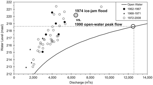
Figure 2. Hydrograph showing open-water and ice-influenced streamflow conditions observed on the lower Athabasca River just below Fort McMurray in the headwaters of the Mackenzie River Basin over the 2008 water year. Also shown on the figure are key hydrograph variables: (1) fall freeze-up magnitude and timing, (2) ice-influenced season, (3) spring freshet initiation date and magnitude, (4) spring breakup magnitude and timing, (5) hydrograph rise rate, (6) peak flow magnitude and timing, (7) hydrograph fall rate, (8) open-water season, (9) low-flow magnitude and timing, (10) number of times the hydrograph reverses direction, and (11) baseflow (source of hydrometric data, Environment Canada Citation2013; modified from Peters et al. Citation2014a).
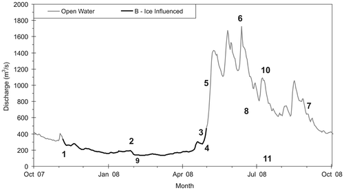
Table 1. Examples of habitat and biological response under increasing hydrological disturbance.
Figure 3. The four-dimensional nature of the riverine ecosystem (Ward Citation1989; Ward and Standford Citation1989): longitudinal connectivity along the entire length of a stream; periodic lateral connectivity to the floodplain and/or riparian zone (terms often used for the same streamside areas), and the resulting exchange of water, sediment, organic matter, nutrients and organisms; vertical connectivity between the atmosphere, streamflow and groundwater; temporal connectivity of continuous physical, chemical and biological interactions over time. As outlined in the text, the floodplain provides a mosaic of aquatic habitats, such as oxbow lakes and wetlands, and potential floodwater storage areas.
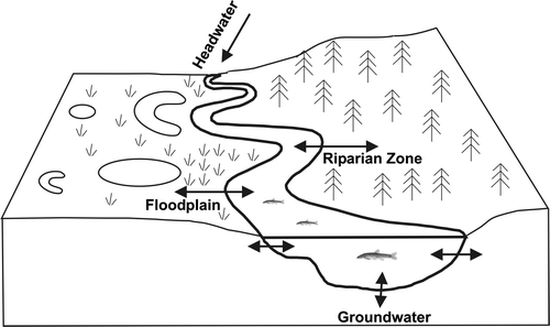
Figure 4. The flooded floodplain forest along the Oldman River in southwestern Alberta during a 10-year flood (QT10), 19 June 2014. Features include: (1) the river channel; (2) an eroding cut-bank along the outside of a meander; (3) a submerged meander lobe point bar with young cottonwood saplings from the prior flood of 2005; (4) flooded groves of narrowleaf and prairie cottonwoods and their hybrids; (5) exposed terraces above the floodplain that are used for livestock pasture (lower right) or cultivated crops (upper; not shown); and (6) the hillslopes that lack trees due to insufficient local precipitation. In wetter regions, terraces and hillslopes are wooded, generally by conifers in many Canadian ecoregions.
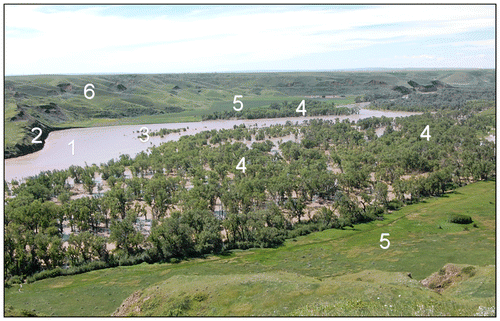
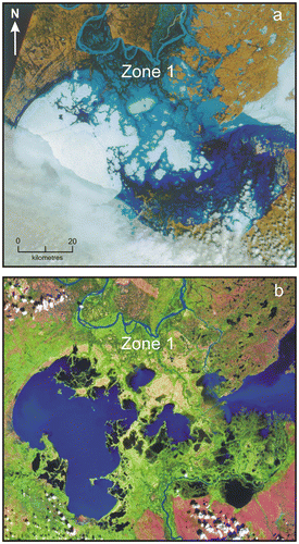
Figure 5. Landsat satellite images of the Peace–Athabasca Delta in northern Alberta: (a) early May 1974, showing the extensive ice-jam generated overland flow (blue) and ice (white); (b) late June 1990, following the all-time high open-water flow event measured on the lower Peace River that resulted in less than bankfull flow conditions (blue) and no apparent flooding of perched basins (green areas in Zone 1). As highlighted in Figure 1, the ice-jam event generated backwater levels > 1.5 m higher with considerably less discharge than the peak flow event that did not overflow the river bank in Zone 1 (modified from Peters et al. Citation2014a).