
Figures & data
Figure 1. Precipitation compared to historical distribution, 1 April–30 June 2014 (Agriculture and Agri-Food Canada Citation2014).
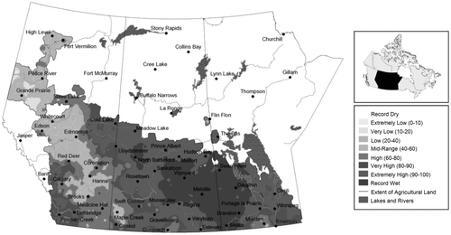
Figure 2. Accumulated precipitation, 17–23 June 2014 (Agriculture and Agri-Food Canada Citation2014).
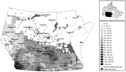
Figure 3. Accumulated precipitation, 24–30 June 2014 (Agriculture and Agri-Food Canada Citation2014).
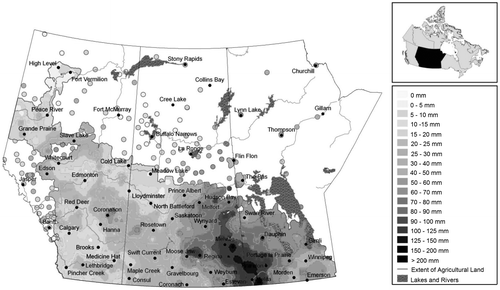
Figure 4. 2014 provisional flows (dark lines) and recorded maximum daily discharges (gray lines) for the Assiniboine River (Kamsack 05MD004, Russell 05ME001, Brandon 05MH013 and Holland 05MH005), Qu’Appelle River (Welby 05JM001) and Souris River (Wawanesa 05NG001). The recorded maximum daily discharge represents the maximum daily value for each day over the entire record for each station.
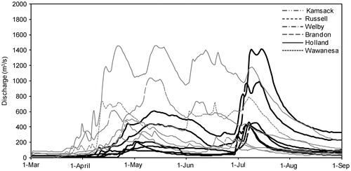
Figure 5. Provisional and recorded maximum daily water levels for 2014 upstream of the Shellmouth Dam. The recorded maximum daily water level represents the maximum daily value for each day over the entire record for each station.
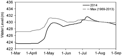
Figure 6. Provisional flows recorded on the Assiniboine River (Holland 05MH005, Portage 05MJ003) and Portage Diversion (Portage 05LL019) from April to August 2014.
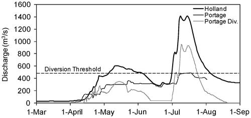
Figure 7. (a) Flow rates through the Portage Diversion; (b) annual volume of water conveyed to Lake Manitoba through the Portage Diversion (1 dam3 = 1000 m3).
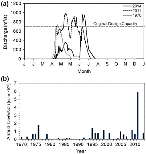
Figure 8. Provisional water levels and recorded maximum daily water levels for 2014 in Lake Manitoba (Steep Rock 05LK002) and Lake St. Martin (Hilbre 05LM005). The recorded maximum daily water level represents the maximum daily value for each day over the entire record for each station.
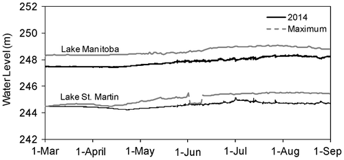
Figure 9. Peak flows and levels for 2014 and 2011 in the Lower Assiniboine Watershed.
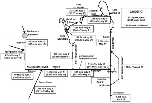
Figure 10. Frequency analysis of Assiniboine River flows (near Brandon). The black lines represent the logarithmic regression between peak flows and return periods, and the gray lines are the 95% confidence limits for each data set. The United States Geological Survey Bulletin 17B method was used for including historical floods of 1882, 1902 and 1904. The empirical equation T = (N + 0.2)/(r – 0.6) was used to calculated the plotting position [T = return period (year), N = no. of data, and r = rank].
![Figure 10. Frequency analysis of Assiniboine River flows (near Brandon). The black lines represent the logarithmic regression between peak flows and return periods, and the gray lines are the 95% confidence limits for each data set. The United States Geological Survey Bulletin 17B method was used for including historical floods of 1882, 1902 and 1904. The empirical equation T = (N + 0.2)/(r – 0.6) was used to calculated the plotting position [T = return period (year), N = no. of data, and r = rank].](/cms/asset/f17b6db6-c81f-484d-a02c-2f0e99cac2e7/tcwr_a_1070695_f0010_b.gif)