Figures & data
Figure 1. The Red Deer, Bow, Oldman and Elk river basins, showing the locations of the Water Survey of Canada gauging stations used, Marmot Creek Research Basin, and the places affected by the flood.
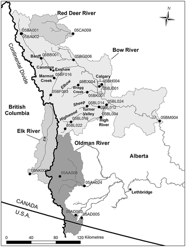
Figure 2. Snow accumulation in the region. (a) Snow water equivalent for the snowpillow at 2120 m at Little Elbow Summit (05BJ805); (b) snow water equivalent from University of Saskatchewan snow surveys just above the treeline (2325 m) on Fisera Ridge in Marmot Creek Research Basin, Kananaskis Valley.
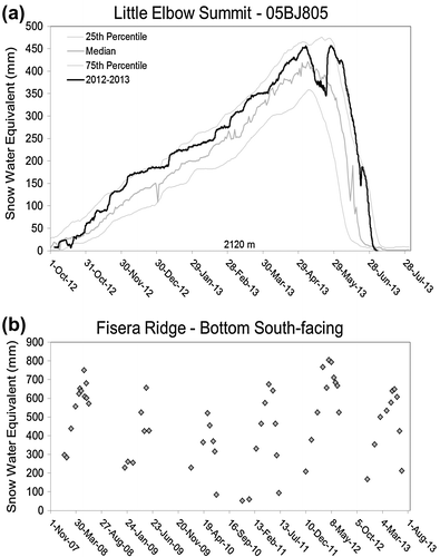
Figure 3. The accumulated precipitation for 19–22 June 2013 in Alberta – calculations and map provided by Alberta Environment and Sustainable Resource Development, Edmonton. Used with permission of Alberta Environment and Parks.
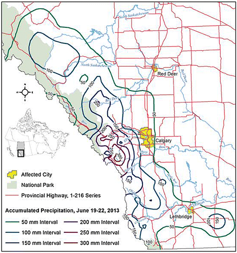
Figure 4. Precipitation in Marmot Creek Research Basin, Kananaskis Valley during the flood. (a) Rainfall rates measured at 1436 m in the valley bottom and recorded every 15 min. (b) daily precipitation depths from 19 to 25 June, from 1436 to 2325 m. These depths were measured using a Geonor weighing gauge at 1436 m, a Geonor and a tipping bucket rain gauge at 1844 m, and a Geonor and tipping bucket rain gauge for rainfall and the depth of fresh snow on the ground (assuming density = 100 kg/m3) for snowfall at 2325 m where a transition to snowfall occurred on the 21st.
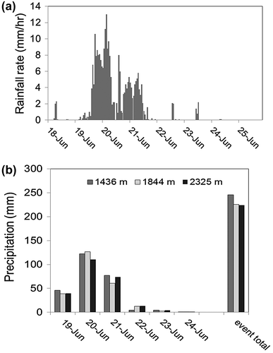
Figure 5. Snow water equivalent (cm or inches) as predicted from the US National Weather Service SNODAS national snow analysis for 19 June 2013 in the “Northern Rockies” including parts of the Canadian Rockies headwaters of the Bow, Elk and Oldman river basins (National Operational Hydrologic Remote Sensing Center, Citation2013).
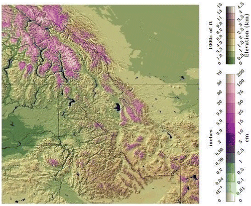
Figure 6. The timing of tributary water levels in the affected area in 2013 – Crowsnest River at Frank, Elbow River at Bragg Creek, Sheep River at Black Diamond, Cataract Creek near Forestry Road, Highwood River near the mouth and Elk River at Fernie. Manual observations made at these stations are shown with points. Data courtesy Water Survey of Canada.
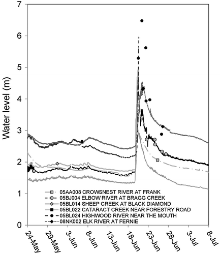
Table 1. Timing of observed highest water level during the 2013 event. Station names shown in italics have some degree of flow regulation.
Figure 7. Water levels along the Bow River from upstream to downstream during the 2013 flood. Bow River at Lake Louise, at Banff, at Calgary (upstream of Elbow confluence) and below Bassano Dam. Manual observations are shown with points.
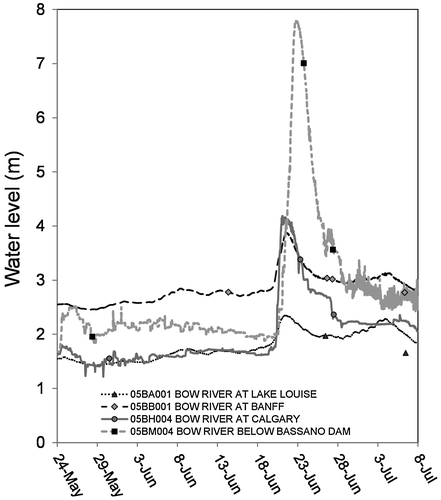
Figure 8. Estimated return periods for the Bow River at Banff from 1884 to 2013 by rank and fitted using the log Pearson type III distribution (solid line), with 95% confidence intervals plotted as dashed lines. Circle is measured peak flow; triangle is annual maximum of a partial year; hollow square is estimated as noted by the Water Survey of Canada. The 2013 event is third from the right (439 m3/s).
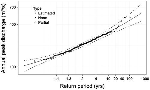
Figure 9. Time series of Bow River discharges from upstream to downstream. Bow River at Lake Louise, at Banff, at Calgary and below Bassano Dam. Also shown are discharges for the Pipestone River near Lake Louise and Fish Creek near Priddis. Note that discharges downstream of the Bow River at Banff, except for Fish Creek near Priddis, are not natural flows.
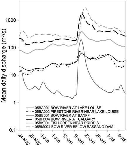
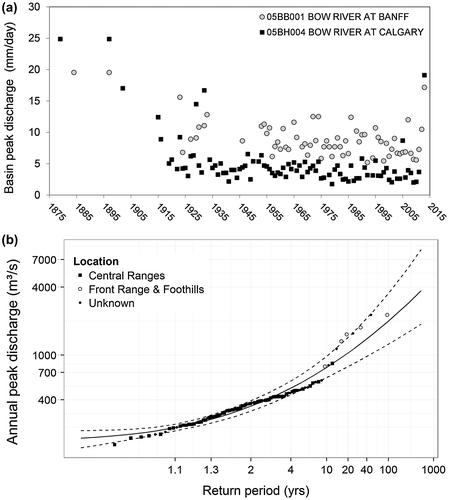
Figure 10. Peak flow source areas for the Bow River and impact on peak flow frequency analysis for Calgary from 1879 to 2013. (a) Annual peak flow time series expressed as runoff per unit area over the gross basin area for the Bow River at Banff and at Calgary. (b) Return period analysis of peak discharge by rank for the Bow River at Calgary fitted to a log Pearson type III distribution (solid line with 95% confidence intervals as dashed lines) and segregated by primary source area; Central Ranges (upstream of Banff) or Front Ranges and foothills (downstream of Banff).