Figures & data
Figure 1. Location maps for (a) the Matane River basin, Québec, Canada; (b) the study site within the coarse sand/gravelly floodplain; and (c) the piezometers within the study site. The names of the piezometers reflect the perpendicular distance (in m) from the Matane River. The river stage sensor and the automatic camera are indicated. asl: above sea level.
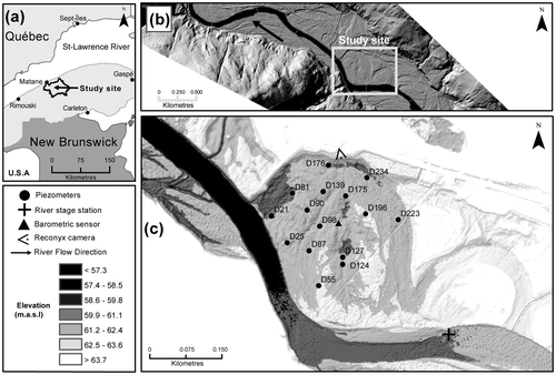
Table 1. Sampling and physical properties for the 15 piezometers installed at the study site. The names of the piezometers refer to the perpendicular distance of the sensors to the river bank (in m).
Figure 2. Time series for (a) river stage and groundwater levels at three locations in the floodplain for the entire sampling period; (b) river stage and groundwater levels at three locations in the floodplain for a 2-month period – three selected flood events are indicated using black triangles. Selected flood events for the cross-correlation analysis are indicated using a black triangle at the time of the peak flow. The water level in the river is at a higher elevation than the water table elevation measured within the study site because the river gauge is located slightly upstream from the site. masl: metres above sea level.
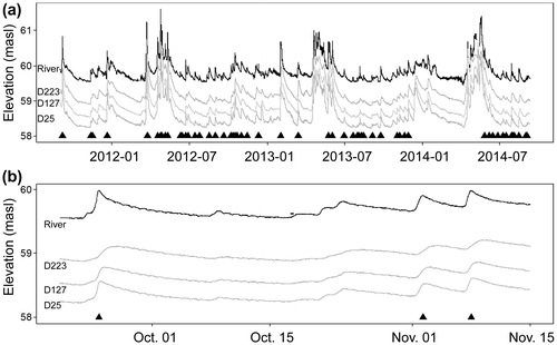
Figure 3. (a) Time lags at which the maximum correlation occurred for a single flood event between the river stage and the groundwater level time series, in relation to the distance from the river bank where the groundwater was measured for all piezometers (n = 15) of the study site. The inverse of the slope represents the propagation velocity. (b) Distribution of propagation velocities for the 54 flood events as computed from the relationship between the time lag of rxy_max and distance from the river bank. (c) Distribution of the coefficients of determination (R2) from the linear relationship between the time lag of rxy_max and the distance from the river bank for the 54 flood events.
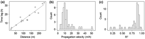
Figure 4. Mean (of the 54 flow events) time lags at which the maximum correlation was measured from cross-correlation analysis between river stages and groundwater levels for all 15 piezometers: (a) using the perpendicular distance between the piezometers and the river bank; (b) using the upstream distance between the piezometer and the river bank. The error bars represent the 95% confidence interval.
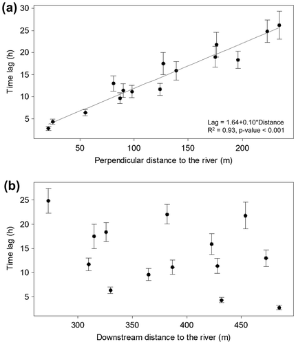
Figure 5. (a) Groundwater amplitude fluctuations in relation to the river stage amplitude for the 54 selected flood events. For each river stage amplitude, groundwater amplitudes for the 15 piezometers are shown. (b) Mean groundwater amplitudes (of the 54 flow events) recorded by the piezometers as a function of the perpendicular distance of the piezometers from the river banks for all 15 piezometers. (c) Mean ratio of groundwater amplitude (GW) to the river stage amplitude (SF) for the 54 selected flood events as a function of the perpendicular distance from the river banks for all 15 piezometers.
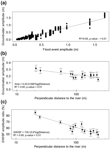
Figure 6. Dispersion diagrams showing propagation velocity with flood event characteristics for the 54 flood events: (a) maximum river stage, (b) initial river stage, (c) rising limb, (d) flood amplitude, (e) time since last flood, and (f) initial groundwater level.
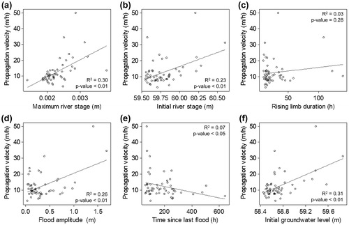
Figure 7. (a) Propagation velocity measured for the 54 selected flood events according to their season of occurrence. (b) Mean time lag for the 54 flood events at which the maximum correlation occurs between river stage and groundwater levels, in relation to the perpendicular distance from the river banks to where the groundwater was measured according to the season of occurrence.
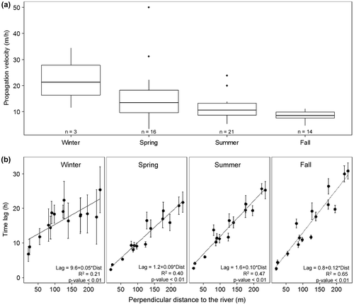
Figure 8. Time series of hydraulic gradients from the linear regression for the 15 piezometers between groundwater levels and perpendicular distances from the banks for (a) a 2-month period (same period as shown in Figure b) and (b) the 3-year period. Negative values suggest that the hydraulic gradient is from the river towards the floodplain. The black triangles indicate flood events. The dashed lines indicate regions where hydraulic gradients are not significantly different from zero. December to July are indicated with gray areas.
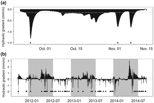
Figure 9. (a) Groundwater flooding events revealed by a picture taken from the reconyx camera at a flood event of 254 m3/s. (b) Time series of river stages with indication of a period of groundwater flooding from hydraulic head measurements above the floodplain surface. The dashed line represents the bankfull discharge level. (c–k) Water pressure expression maps for nine flood events. The water pressure is expressed as a measure of hydraulic head measure above or below the floodplain surface. The dark gray to black shade indicates increasing increasing hydraulic head above the floodplain surface, while the light gray to white shade colours indicate the depth below the surface at which the groundwater levels are found. The bottom parts of e and j are empty due to missing data for the flow events.
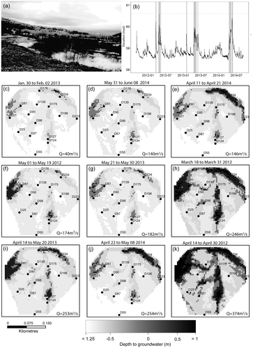
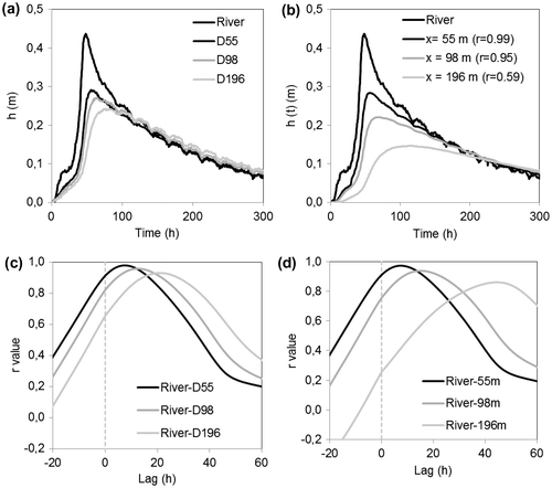
Figure 10. Water table responses to a flood event at different distances from the river: (a) measured in this study and (b) simulated using Dong et al. (Citation2013). Cross-correlation functions between the river stage and (c) measured water table levels and (d) simulated water table levels.