Figures & data
Figure 1. Flood disasters in Canada by type between 1990 and 2013.
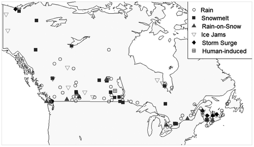
Table 1. Mean annual extreme rainfall depth and hourly intensity for various durations for locations in regions of Canada, as denoted by the maximum isohyet shown in Hogg and Carr (Citation1985). Depths and intensities are given for locations with secondary maxima within a given region if present.
Figure 2. Floods in Canada identified by Brooks et al. (Citation2001) and the Canadian Disaster Database, CDD (Public Safety Canada Citation2014). The CDD does not contain all floods but only those considered significant because of financial transfers. Adjusted costs are based on 2010 Canadian dollars and were adjusted for the Canadian Consumer Price Index.
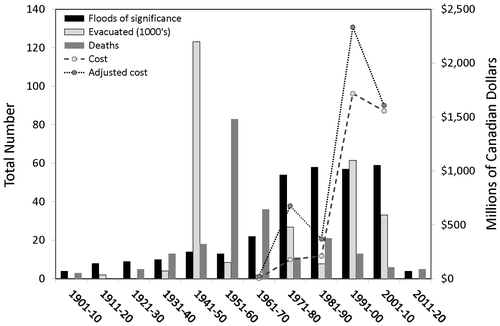
Table 2. A typology of floods, based upon two levels of flood generating processes, after Whitfield (Citation2012). The final column indicates event case studies detailing events that have occurred since 1995.
Table 3. Flood-generating processes, inundation types and modifying conditions and risks. The flood-generating processes are described in more detail in Table 1. Many of these factors exhibit seasonal variation.
Table 4. Major drainage basins in Canada.
Figure 3. Daily runoff for selected rivers within the Maritime Provinces and Newfoundland and Labrador.
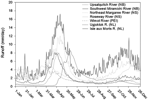
Figure 4. Flood flows (50-year flood) for rivers within the Maritime Provinces and Newfoundland and Labrador (data from Department of Environment and Lands Citation1992; Caissie and Robichaud 2006).
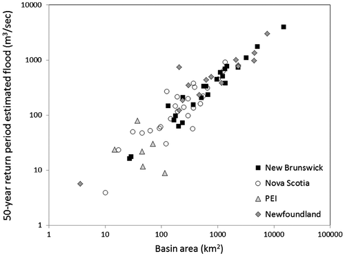
Figure 5. Maximum daily mean discharge vs. basin area for unregulated Water Survey of Canada (WSC) gauging stations in sub-regions in Québec. Maximum daily mean discharge was obtained for all naturally flowing stations in the region with 10 years or more of discharge record with a known drainage area, and includes all active and discontinued sites (data from WSC Citation2014).
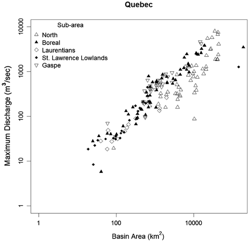
Figure 6. (a) Physiographic regions of southern Ontario identified by Moin and Shaw (Citation1985). (b) Maximum recorded flood (daily mean discharge) vs. basin area recorded at unregulated or minimally regulated Water Survey of Canada (WSC) gauging stations in each region with at least 10 years of record to 2012.
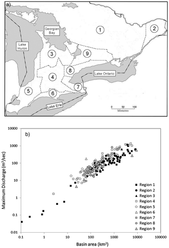
Figure 7. Maximum daily mean discharge vs. basin area for unregulated Water Survey of Canada (WSC) gauging stations in major drainages across the boreal forest in the Yukon Territory, British Columbia, Northwest Territory, Alberta, Saskatchewan, Manitoba, Ontario, Québec and Labrador. Drainage basin numbers correspond to the major drainage basins of Canada used by WSC (see Table ).Maximum daily mean discharge was obtained for all naturally flowing stations in the region with 10 years or more of discharge record with a known drainage area, and includes all active and discontinued sites (data from WSC Citation2014).
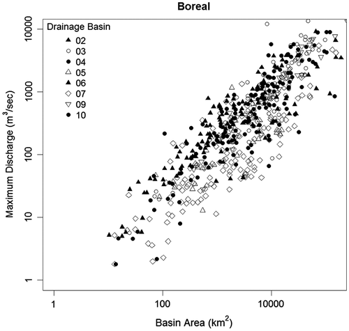
Figure 8. Maximum daily mean discharge vs. basin area for unregulated Water Survey of Canada (WSC) gauging stations in sub-regions of the Prairies. Drainage basin numbers correspond to the major drainage basins of Canada used by WSC (see Table ). Maximum daily mean discharge was obtained for all naturally flowing stations in the region with 10 years or more of discharge record with a known drainage area, and includes all active and discontinued sites (data from WSC Citation2014).
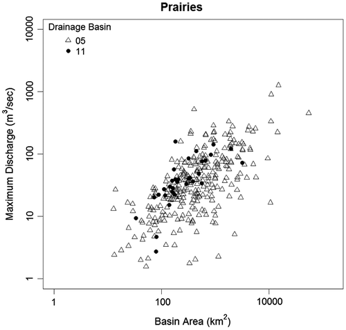
Figure 9. Maximum daily mean discharge vs. basin area for unregulated Water Survey of Canada (WSC) gauging stations in sub-regions of the Cordillera in British Columbia. Maximum daily mean discharge was obtained for all naturally flowing stations in the region with 10 years or more of discharge record with a known drainage area, and includes all active and discontinued sites (data from WSC Citation2014).
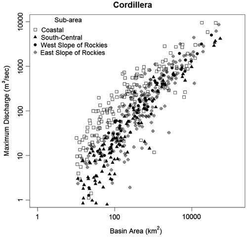
Figure 10. Discharge for the Bow River at Banff, Alberta for the 20–21 June 2013 flood, and groundwater level in the alluvial aquifer in Canmore, Alberta.
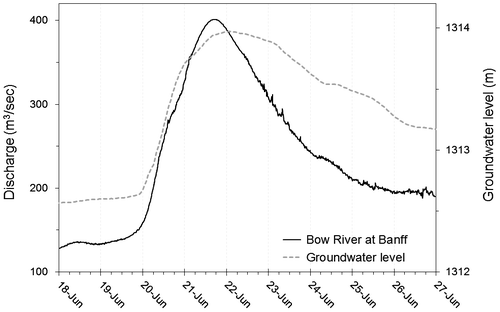
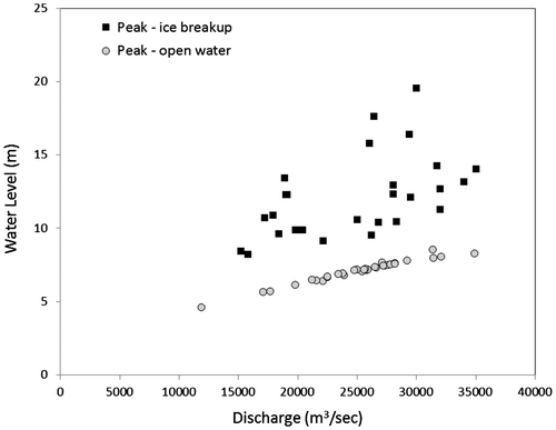
Figure 11. Open-water and ice-influenced peak water levels vs. discharge at the Mackenzie River at Arctic Red River Water Survey of Canada (WSC) station for the years 1972 to 2006 (modified from von de Wall et al. Citation2010).