Figures & data
Figure 1. Location of the three studied watersheds – the Des Fèves, Lacolle and L’Acadie Rivers – as well as the three sites where crop productivity was assessed near the stream (sites A, B and C).
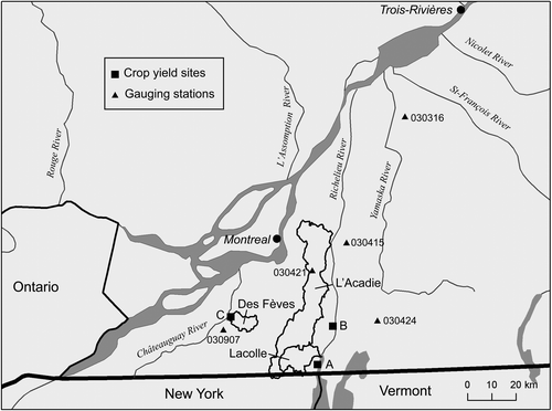
Table 1. Main characteristics of the three study reaches.
Table 2. Detailed information on the streams used to establish regional curves.
Table 3. Four levels of discharge used in hydraulic modelling, along with the calibrated Manning’s n.
Figure 2. (A) Horseshoe wetland design for agricultural fields with a limited riparian buffer such as those typically encountered in Quebec, and (B) integration of horseshoe wetland cross-sections in. Hydrologic Engineering Center's River Analysis System (HEC-RAS).
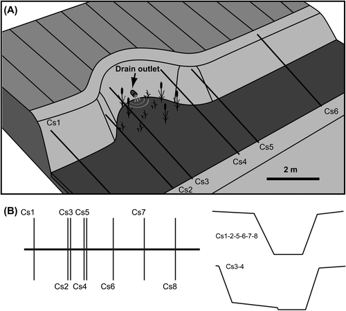
Figure 3. (A) Diagram showing the dimensions of two-stage channels; (B) regional curves of bankfull channel geometry (Montérégie) for the inset width (Winset in A) and depth.
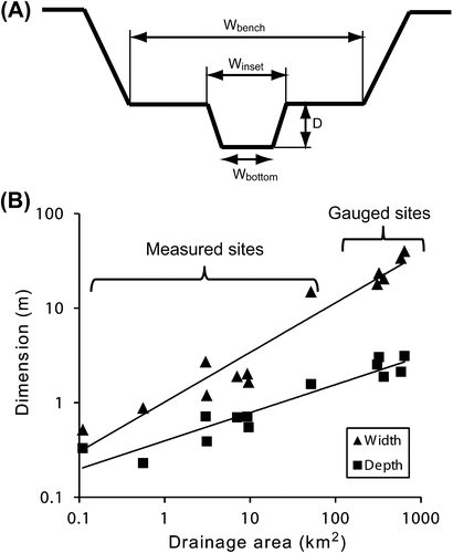
Figure 4. Visual representation of a two-stage channel design (3 and 5 times the inset channel width) over an actual cross-section of branch 53 of the Des Fèves River, also showing the location of the deep subsurface drainage outlet measured in the field (the inset channel width is 1.62 m).
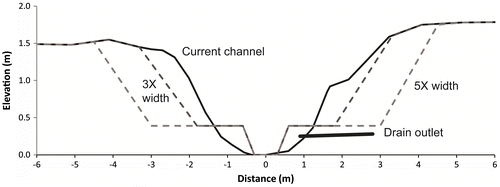
Table 4. Additional width required for each bank and corresponding volume of spoil to be removed for two-stage and over-wide ditch designs.
Figure 5. Hydrologic Engineering Center's River Analysis System (HEC-RAS) output for (A) the actual channel configuration of the Lacolle site, (B) the corresponding two-stage profile with 3 times the inset channel width, and (C) the corresponding two-stage profile with 5 times the inset channel width compared to the floodplain width. Values on the right in B and C correspond to the difference in flow stage compared to the actual channel for the four discharge values.
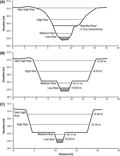
Table 5. Effect of the two-stage profiles on the maximum in-stream discharge (drainage capacity).
Table 6. Sensitivity analysis of water stage for the very high flow discharge of the Lacolle site (6.5 m3/s) when increasing Manning’s n.
Table 7. Flow characteristics before and after integration of a 3 × 3 m horseshoe wetland on a 6-m wide ditch.
Table 8. Comparison of total cost for a traditional dredging approach, self-formed channel approach, two-stage channel and over-widened channel designs.
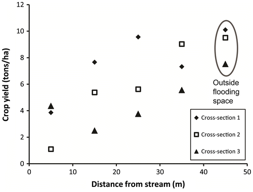
Figure 6. Maize crop yields for different distances to the stream in 2014 at site C (Des Fèves River).