Figures & data
Figure 1. Map of study area, surrounding region, and drainage area for the downstream-most location sampled on each stream.
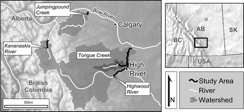
Figure 2. Mapped climatic parameters of study watersheds, modelled using geographically weighted regression (GWR). (a) Total annual precipitation (mm of water equivalent); (b) total annual snowfall (cm of fresh snow); (c) mean annual temperature (°C). Data source: Canadian Climate Normals 1981–2010, climate normal and averages (Environment and Climate Change Canada Citation2016).
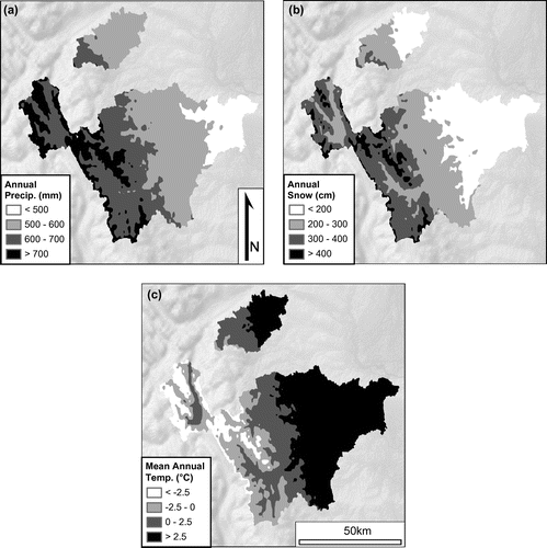
Figure 3. Estimated chronological extent of field-determined intervals used in this study. Circles represent the mean values of the upper and lower limits (vertical bars) per class. The tephra chronostratigraphic layer, the Mazama ash, is indicated by the dashed line, dated to ~7600 cal. yr BP (Zdanowicz et al. Citation1999; Egan et al. Citation2015).
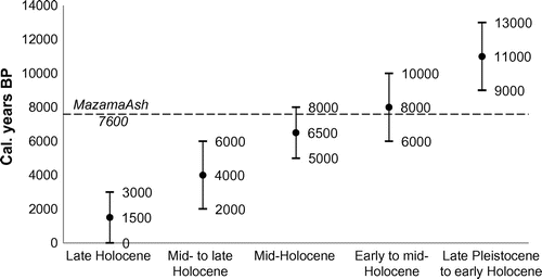
Table 1. 14C dates, calibration, and comparative radiocarbon and field-determined age classes. Near-modern samples (denoted by *) were calibrated with the Bomb13NH1 curve (Hua et al. Citation2013), all others used the IntCal13 curve (Reimer et al. Citation2013). Samples processed at the André E. Lalonde Accelerator Mass Spectrometry Laboratory (Ottawa, Ontario) and the Keck Carbon Cycle Accelerator Mass Spectrometry facility (Irvine, California).
Table 2. Number of localities and samples, and maximum stream-course distance between sites per stream.
Table 3. List of Linnaean and common names, authorities, and organismal groups of indicator taxa used for climate reconstruction.
Figure 4. Climate space (annual precipitation and mean annual temperature) diagram of 15 indicator taxa. Discus whitneyi = Dw, Eleocharis palustris = Ep, Euconulus fulvus = Ef, Galba modicella = Gm, Gyraulus parvus/circumstriatus = Gp/c, Helisoma anceps = Ha, Physa gyrina = Pg, Pisidium spp. = Psdm, Potamogeton spp. = Pgtn, Scirpus microcarpus = Sm, Stagnicola elodes = Se, Succineidae = S, Vallonia gracilicosta = Vg, Zannichellia palustris = Zp, and Zonitoides spp. = Za/n. Note: some labels have been slightly moved from their centroids to aid legibility.
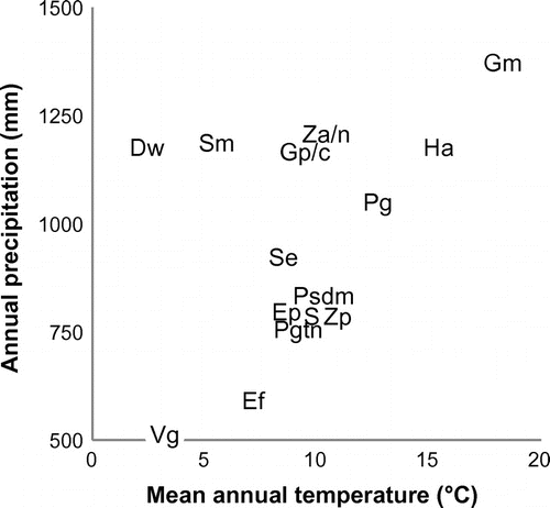
Figure 5. Pie chart depicting the number of samples per age class.
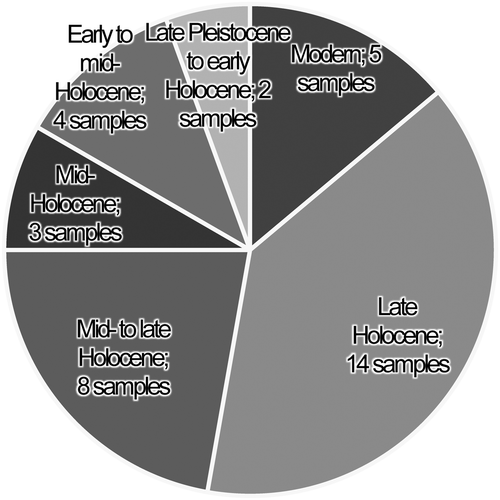
Table 4. Average number of indicators (by taxon) per age class and per sample. The initial value is the count of a taxon in all samples of an age class; the value in parentheses is the average value per sample; values with * are maximum values (e.g. AV = 1) for that taxon.
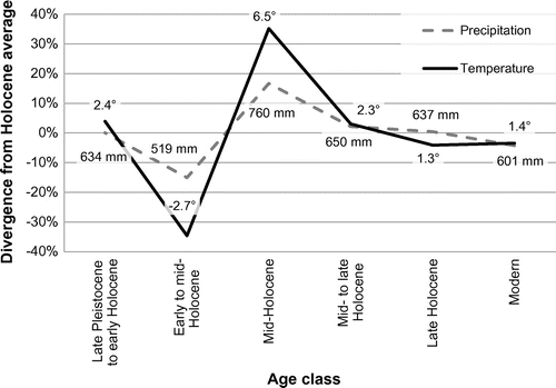
Figure 6. Modelled annual precipitation and mean annual temperature for the study region; plotted values represent uncalibrated percent divergence from mean; data labels indicate calibrated values (precipitation is in mm; temperature is in °C).