Figures & data
Figure 1. Study area. (a) Bedrock geology based on a compilation of geological maps at the 1:20,000 scale from the government of Québec, Système d'information géominière [SIGEOM] from the Ministère de l'Énergie et des Ressources naturelles du Québec [MERN]) (b) Surficial geology adapted from maps produced by the Geological Survey of Canada (Veillette Citation2004; Thibaudeau and Veillette, Citation2005; Paradis Citation2005, Citation2007; Veillette, Citation1986a, 1986b, 1987a, 1987b, 1987c); (c) elevation and continental water divide; (d) stratigraphic boreholes from geological and hydrogeological government databases.
![Figure 1. Study area. (a) Bedrock geology based on a compilation of geological maps at the 1:20,000 scale from the government of Québec, Système d'information géominière [SIGEOM] from the Ministère de l'Énergie et des Ressources naturelles du Québec [MERN]) (b) Surficial geology adapted from maps produced by the Geological Survey of Canada (Veillette Citation2004; Thibaudeau and Veillette, Citation2005; Paradis Citation2005, Citation2007; Veillette, Citation1986a, 1986b, 1987a, 1987b, 1987c); (c) elevation and continental water divide; (d) stratigraphic boreholes from geological and hydrogeological government databases.](/cms/asset/6ba4bfec-4e8e-4424-9efe-7e6e0c5c6d8f/tcwr_a_1354722_f0001_oc.gif)
Figure 2. Regional stratigraphic column (unconsolidated sediments) and associated simplifications used in the stratigraphic sequence map. For simplification purposes, the till unit is considered here to be composed of silt, sand and gravel.
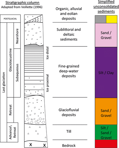
Figure 3. Conceptual representation of the approach for constructing the stratigraphic sequence map.
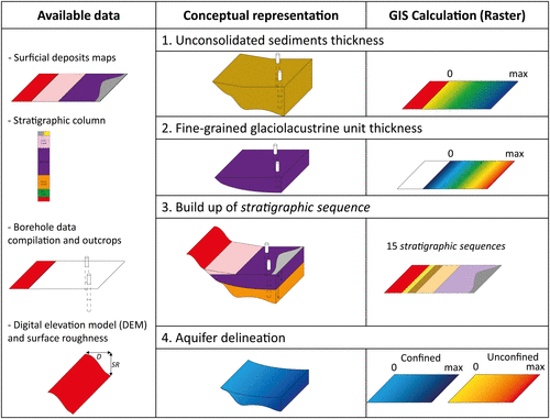
Figure 4. Average range of surface elevation (referring to surface roughness, SR) for groups of geological units within predefined diameters.
Table 1. Average range (in meters) of surface elevation (surface roughness, SR) and associated standard deviations (σ) within a predefined circle diameter (distance) for groups of geological units.
Table 2. Data sources and number of boreholes (n) for evaluating unconsolidated sediment thickness (UST).
Figure 5. GIS-based procedures for evaluating (a) the unconsolidated sediment thickness (UST) and (b) the fine-grained glaciolacustrine unit thickness (FGGUT). DNBO: distance to nearest bedrock outcrop; MF: multiplication factor; MUST: maximum unconsolidated sediment thickness; DEM: digital elevation model; DNL: distance to nearest limit of the clay plain.
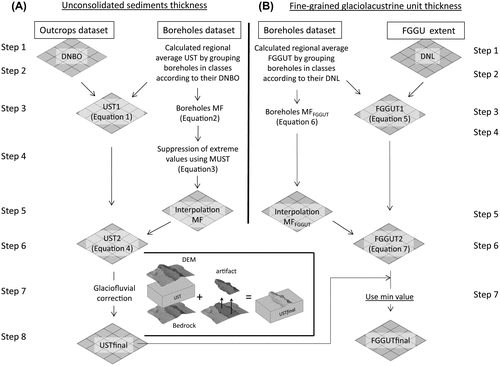
Figure 6. Regional trend of average unconsolidated sediment thickness (UST, solid line) vs. distance to nearest bedrock outcrop (DNBO) and maximum plausible unconsolidated sediment thickness (MUST) equal to the average UST, plus surface roughness of bedrock (SR), plus twice the standard deviation on the SR ( in m), both with reference to the left-side y-axis. The number of available borehole data (dashed line) with respect to each class of DNBO is shown, with reference to the right-side y-axis.
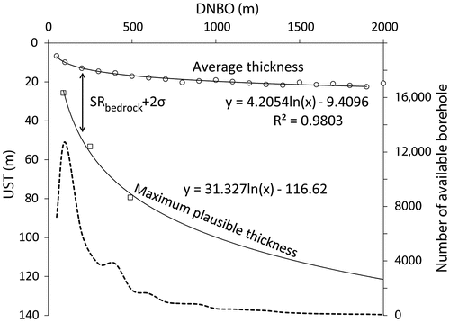
Table 3. Data sources and number of boreholes (n) for evaluating the fine-grained glaciolacustrine unit thickness (FGGUT).
Figure 7. Conceptual GIS-based method to define the reference surface delineating the maximum elevation of the fine-grained glaciolacustrine unit (FGGU). The surface is obtained by interpolating the highest elevations reached by the FGGU.
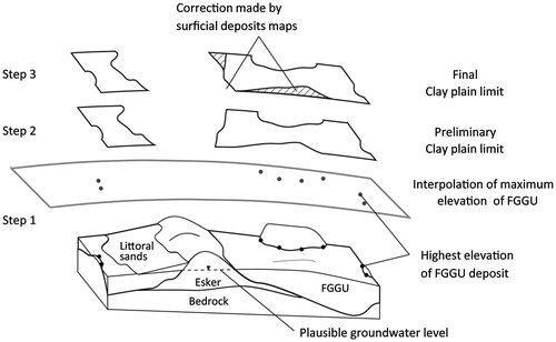
Figure 8. Regional trend of average fine-grained glaciolacustrine unit thickness (FGGUT, solid line) vs. distance to the nearest limit of reference plan (DNL), with reference to the left-side y-axis. The number of available borehole data (dashed line) for each class of DNL is shown, with reference to the right-side y-axis.
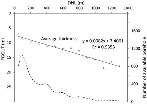
Table 4. Description of the criteria for defining the 15 regional stratigraphic sequences.
Figure 9. Main regional-scale outputs of the GIS-based calculations. (a) Unconsolidated sediment thickness (UST); (b) fine-grained glaciolacustrine unit thickness (FGGUT); (c) stratigraphic sequence map; (d) calculated aquifer thicknesses. The black rectangle corresponds to the area covered in Figure which provides local-scale data for a sector located west of the city of Amos.
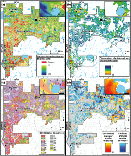
Figure 10. Local-scale illustration of the consistency between the maps and datasets supporting the construction of the stratigraphic sequence map. (a) Unconsolidated sediment thickness (UST). (b) Fine-grained glaciolacustrine unit thickness (FGGUT). (c) Surface geology map. (d) A–A` cross section showing the bedrock (red) and overlying coarse-grained (orange) and fine-grained (purple) sediments. The numbers reported above the cross section correspond to the different stratigraphic sequences, as identified in Table . (e) Corresponding local-scale stratigraphic sequence map with numbers corresponding to the different stratigraphic sequences identified in Table .
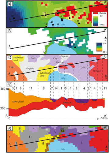
Table 5. Descriptive statistics and volume estimates in relation to the 15 regional stratigraphic sequences.
Figure 11. Average unconsolidated sediment thickness (UST, solid line) and glaciofluvial sediment thickness (dashed line) against bedrock surface elevation. The Cadillac Fault, separating the Abitibi (north) and Pontiac (south) geological sub-provinces and roughly corresponding to the position of the water divide between lakes Ojibway (north) and Barlow (south), is used for partitioning the data.
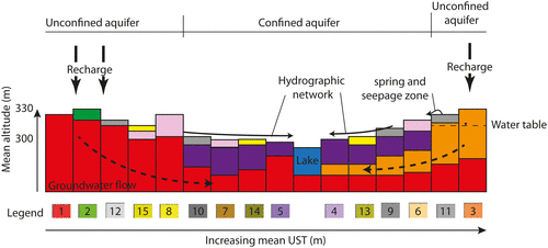
Figure 12. Conceptual representation of regional distribution of stratigraphic sequences and their position among regional flow paths. The stratigraphic sequences are depicted for illustrating their general distribution and elevation within the regional hydrogeologic environment and the numbers correspond to those found in Tables and . The conceptual model suggests increasing unconsolidated sediment thickness (UST) toward the right side of the cross section.