
Figures & data
Figure 1. Maps showing: (a) Location of study area (black square) in relation to Great Lakes; (b) the 29 study watersheds with corresponding sampling site (white circles); and (c) evaluation sites (square – data integrity sites only; octagon – temporal integrity sites only; pentagon – spatial integrity sites only; rounded square – data and temporal integrity sites).
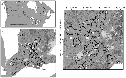
Table 1. Results from K-means cluster analysis classifying years based on climate and discharge averages for the May through November sample season [mean (standard deviation)]. The mean and standard deviation for precipitation and discharge data associated with each cluster were used to identify dry, moderate and wet years.
Figure 2. Mean concentrations of measured stream nitrogen variables from study streams (total nitrogen, dissolved Kjeldahl nitrogen, nitrate-nitrite, ammonia, dissolved organic nitrogen, dissolved inorganic nitrogen, total dissolved nitrogen) represented as box and whisker plots. Sample size = 29 for all variables.
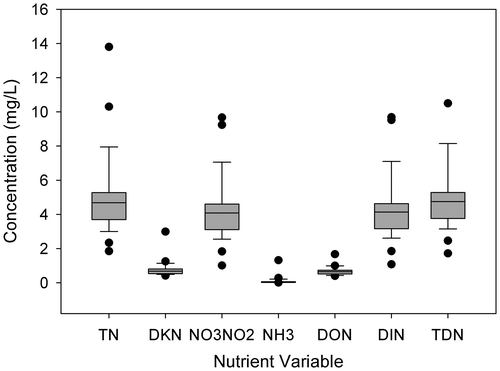
Figure 3. Mean concentrations of measured stream phosphorus variables from study streams (total phosphorus, total dissolved phosphorus, soluble reactive phosphorus) represented as box and whisker plots. Sample size = 29 for all variables.
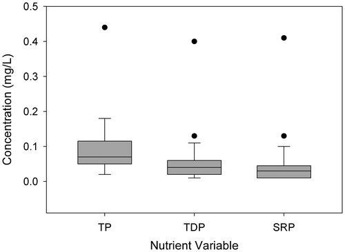
Table 2. Agricultural land-use descriptors described at multiple landscape scales for catchments and riparian buffer areas (30 m width) of 29 stream sites located on lower Great Lakes tributaries in southwestern Ontario, Canada.
Table 3. Urban land-use and sewage treatment plant descriptors described at multiple landscape scales for catchments and riparian buffer areas (30 m width) of 29 stream sites located on lower Great Lakes tributaries in southwestern Ontario, Canada.
Table 4. Variance Inflation Factor (VIF) scores for 29 watersheds in southwestern Ontario indicating the degree of collinearity between the proportion of (a) pervious, (b) impervious, (c) forage and (d) row crop land use quantified for the entire watershed, entire stream buffer, headwater buffer, and 600-m buffer. Also shown for the same watersheds are variance inflation factor scores for measures of sewage release (effluent volume, sewage treatment plant population density and river distance to nearest sewage treatment plant). * identifies regressions with P > 0.95.
Table 5. Results of ordinary least squares regression analyses relating average May–November nutrient concentrations to land-use descriptors for 29 southwestern Ontario watersheds. Outliers are identified by site number in order of exclusion.
Table 6. Performance of regression models developed using 2012 data from 29 Great Lakes watersheds under three scenarios: data integrity, spatial integrity, and temporal integrity (the latter for dry, moderate and wet years). Performance is expressed as the ratio of observed values to model predictions (i.e. observed:expected, O:E) for nitrate-nitrite, total nitrogen, soluble reactive phosphorus and total phosphorus, averaged for all the watersheds (sample size) for which predictions were made. Success is a measure of the number of successful predictions (0.8 ≤ O:E ≤ 1.2) for each scenario and nutrient parameter.
Figure 4. Results of site observed:expected scores for the assessment of predictive performance under data and temporal integrity scenarios (dry, moderate and wet). Black boxes indicate no data were available; grey boxes represent scenarios where site observed:expected scores fell within 20% of 1.0 (0.8–1.2).
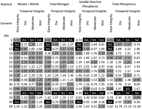
Figure 5. Results of site observed:expected scores for the assessment of predictive performance under the spatial scenario. Grey boxes represent scenarios where site observed:expected scores fell within 20% of 1.0 (0.8–1.2).
