Figures & data
Figure 1. Location and topography of the Chaudière-Appalaches study area, and location of the two-dimensional regional cross-section model, modified from Lefebvre et al. (Citation2015).
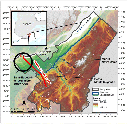
Figure 2. Conceptual model for the Chaudière-Appalaches regional groundwater model, showing (a) flow and geochemical evolution with water types G1, G2 and G3; and (b) the geologic cross-section of the deep subsurface (after Séjourné et al. Citation2013).
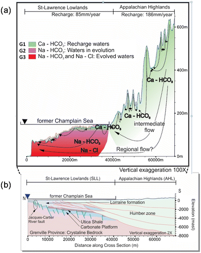
Table 1. Physical description of the surficial deposits, including reported and calibrated hydraulic conductivities.
Figure 3. Vertical distribution of measured and model-generated hydraulic conductivities in the Chaudière-Appalaches region. Grey dots represent estimated values from the well drillers’ log (Lefebvre et al. Citation2015). Black squares show the median measured value per 5-m intervals, and the horizontal whiskers show the 25th and 75th percentiles. Solid lines show the calibrated distribution of hydraulic conductivities in the fractured bedrock, and dashed lines show different conductivity scenarios tested in the sensitivity analysis of Janos (Citation2017).
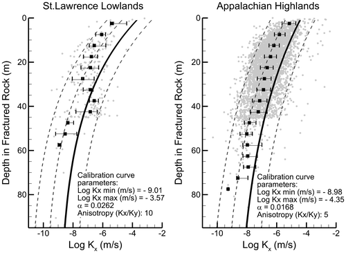
Table 2. Description of the modelled geologic rock units, including the reported and modelled hydraulic conductivities and porosities (includes properties reported by Gassiat et al. Citation2013). Bedrock anisotropy obtained from Freeze and Cherry (Citation1979). Bold values are used in the model.
Figure 4. Geological structure, hydraulic conductivities and boundary conditions for the numerical flow model.
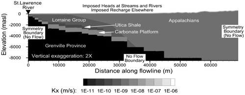
Figure 5. Model calibration: Observed heads (from interpolated regional piezometry) against simulated heads.
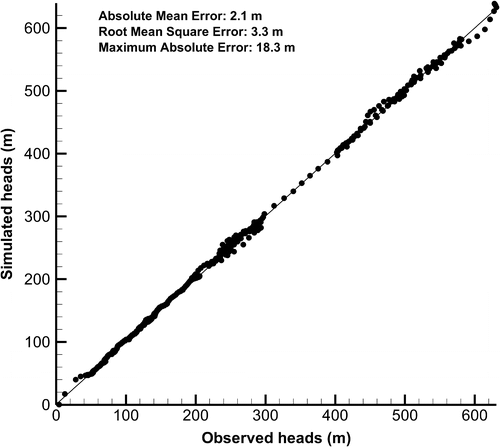
Figure 6. Calibrated recharge fluxes, simulated hydraulic heads, observed water table elevations (from interpolated piezometry) and topographic elevation along the model cross-section. Negative fluxes are exiting the model domain and positive fluxes are entering (corresponding to recharge).
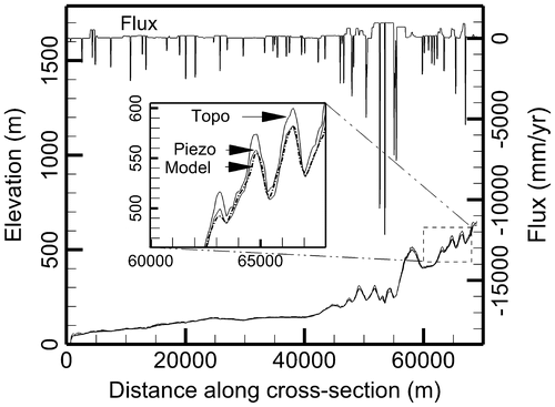
Table 3. Average recharge to the bedrock calibrated from the HELP model and from the current two-dimensional flow model (SLL = St. Lawrence Lowlands, AHL=Appalachian Highlands).
Figure 7. Calibrated steady-state flow model showing hydraulic heads and streamline distribution.
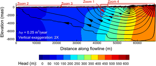
Figure 8. Calibrated flow model: (a) Zoom 1 (Appalachian Highlands), (b) Zoom 2 (St. Lawrence Lowlands close to St. Lawrence River), (c) Zoom 3 (St. Lawrence Lowlands close to Appalachian front), showing hydraulic heads and streamline distribution (location shown in Figure 7).
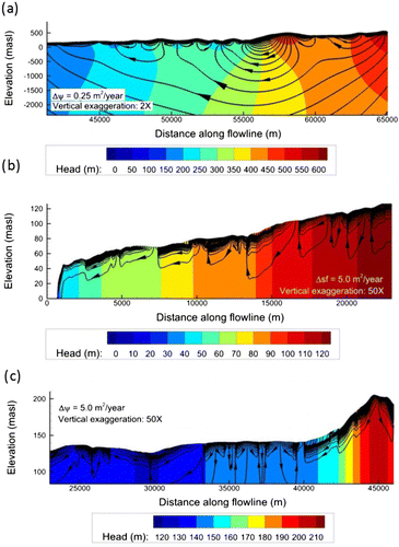
Figure 9. Simulated steady-state mean groundwater ages with superimposed streamlines from the calibrated flow model. (Plot enlargements for Zooms 1, 2 and 4 are provided in Figure ; Zooms 3 and 5 can be found in Janos Citation2017).
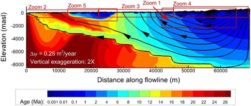
Figure 10. Simulated mean groundwater ages with superimposed streamlines from the calibrated flow model: (a) Zoom 1, (b) Zoom 2, (c) Zoom 4. (Locations shown in Figure 9).
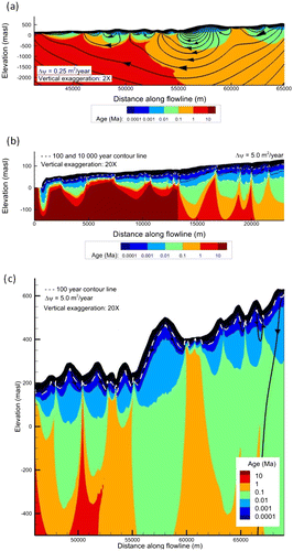
Figure 11. Conceptual model of the Jacques-Cartier River fault zone. Vertical hydraulic conductivities shown correspond to scenario P of the parametric study on faults.
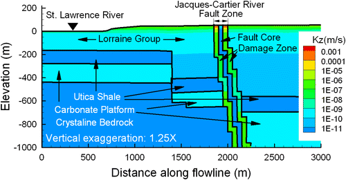
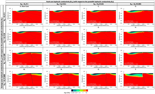
Table 4. Simulated fault permeability scenarios.
Figure 12. Steady-state flow model showing hydraulic conductivities in the horizontal direction and streamlines for fault scenarios described in Table ; vertical exaggeration is 1.25×.
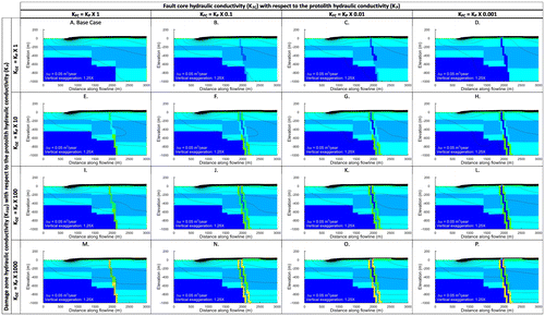
Figure 13. Steady-state flow and age transport model showing mean groundwater age and streamlines for fault scenarios described in Table , vertical exaggeration is 1.25×.