Figures & data
Figure 1. An illustration of a pocket wetland (PW) and the intended flow paths. It is a small constructed wetland located at the outfall of a stormwater management pond. The intent of this design is to intercept stormwater, providing additional flow attenuation and mitigation of poor water quality associated with residential neighborhoods. The PW is heavily vegetated and has a porous storage medium to promote storage of small runoff events and groundwater inputs to the adjacent stream. Larger runoff events may flow through as surface runoff. The PW is designed to promote cooling, aggradation and sedimentation to improve effluent water temperature, total suspended solids (TSS) and total dissolved solids (TDS).
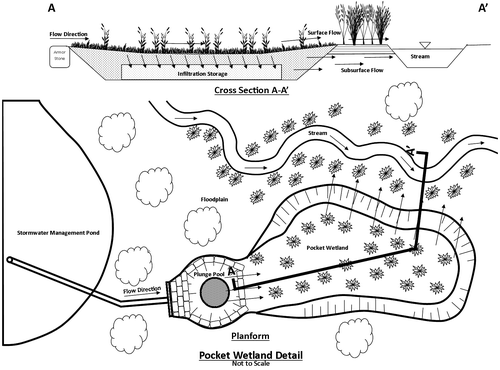
Figure 2. The Churchville pocket wetland (PW) is located north of the intersection of James Potter Rd. and Queen Street West (43°39’49”N, 79°47’07”W) in Brampton, ON, Canada (inset). Runoff from the stormwater catchment (~0.15 km2) drains through conduits into the stormwater pond, and then flows through the PW (~900 m2) before entering Churchville Creek.
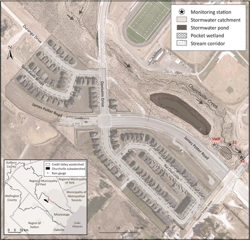
Table 1. Wet meadow seed mix installed in the Churchville pocket wetland (PW).
Figure 3. Rainfall (mm), and atmospheric temperature (°C) (a); total runoff (mm), and water temperature (°C); total dissolved solids (mg/L), and total suspended solids (mg/L) at S1 (b, c), S2 (d, e) and stormwater pond outlet (SWP) (f, g) from 24 May to 30 October 2014.
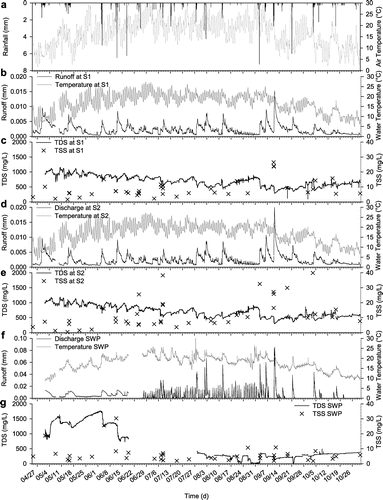
Table 2. Antecedent rainfall (mm), rainfall and runoff duration (h), total rainfall (mm) and runoff (mm), runoff ratios and wetland residence time (h) for 21 rainfall events. Runoff was determined using a straight-line hydrograph separation method to remove baseflow.
Figure 4. The relationship between the total runoff and the total rainfall at S1, S2 and stormwater pond outlet (SWP) monitoring locations for each event between 25 April and 30 October 2014.
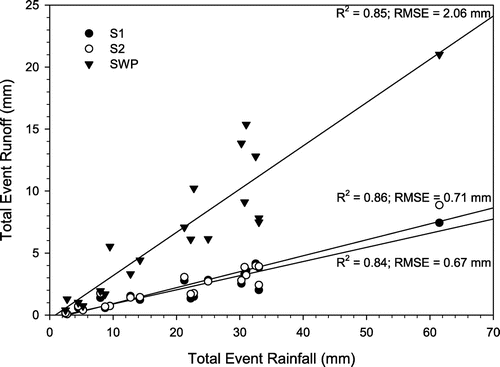
Table 3. Average event and baseflow water temperature, Total Dissolved Solids (TDS), and Total Suspended Solids (TSS), before and after the removal of the orifice plate at the Stormwater Pond (SWP). TSS values are from discrete samples, excluding the pump-sampling events. Effluent flow parameters are the difference obtained in subtracting S1 values from S2. Negative values suggest a decrease or dilution in the parameter.
Table 4. S1 and S2 difference of means (t-distribution) for Total Dissolved Solids (TDS), temperature, temperature (4:00–4:30) and Total Suspended Solids (TSS) with (25 April–25 June 2014) and without (8 September–30 October 2014) the Stormwater Pond (SWP) orifice plate.
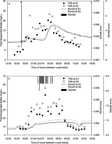
Figure 5. Total suspended solids (TSS) during rainfall events in June (a) and October (b). (a) 17 June rainfall event (mm), total runoff (mm) and TSS (mg/L). Low TSS was recorded for an intense rainfall event. (b) 14 October rainfall event (mm), total runoff (mm) and TSS (mg/L). Although the rainfall intensity was low, with 4.5 mm in 2.8 h, antecedent conditions were dry as 0 mm of rain fell in the previous 5 days.