
Figures & data
Figure 1. Montérégie Est location and hydrogeological contexts based on physiography. Map also shows topography, main roads, the Champlain Sea maximum marine transgression limit (~13,000 to 11,000 years ago) and the trace of the cross sections shown on the three-dimensional block diagram of Figure (dashed red lines).
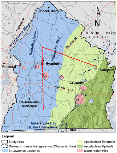
Figure 2. Three-dimensional block diagram of subsurface conditions in Montérégie Est (cross-section locations shown on Figure 1). The generally east–west cross section goes from the Lowlands to the Appalachian Uplands and crosses the thrust faults of the Appalachian Front. The generally north–south cross section remains in the Lowlands but crosses a Monteregian Hill. Till (green) covers most of the bedrock, with local accumulations of fluvio-glacial sediments (orange) or old sediments (brown), and is apparent at the surface in the Appalachian Piedmont and Uplands. Lacustrine (purple) and marine (light blue) fine sediments can form large accumulations in the North Lowlands (more than 30 m thick).
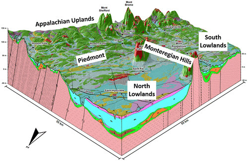
Figure 3. Confinement level of the Montérégie Est fractured rock aquifer system, and extent of brackish groundwater to the north of the region.
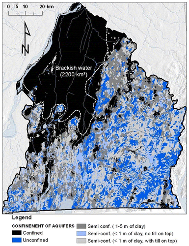
Figure 4. Results of multivariate statistical analysis of geochemical parameters. A, Cluster analysis tree diagram defining the eight water groups below a phenon line of 18. B, Spatial distribution of the 190 samples with colored areas belonging to a water group. C, Values of the first and second components of the principal component analysis for the 190 samples identified with their water group. The names of water groups were assigned on the basis of their spatial distribution (Figure B) and their geochemical characteristics (Figure ): three ‘Appalachian’ groups, A1, A2 and A3; a ‘Lowland’ group, LL; a ‘Champlain Sea’ group, CS; and three ‘Mixed’ or ‘Monteregian’ groups, M1, M2 and M3.
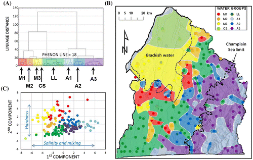
Figure 5. Major ions in groundwater. A, Proportions of major ions for each sample, associated with its water group (color), represented on a Piper diagram. B, Average ionic composition for each water group represented by Stiff diagrams (ions represented and concentration scale shown to the left of diagrams). The order of Stiff diagrams is based on relations between water groups and geochemical evolution paths that will be discussed later.
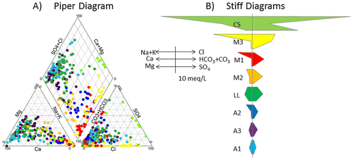
Table 1. Loadings of the 16 geochemical parameters for the first five components (C1 through C5) of the principal component analysis (bold values indicate dominant parameters).
Table 2. Median values of physico-chemical parameters and component concentrations (mg/L) for the water groups defined in Figure 4 (geochemical data and water group statistics are available in Beaudry Citation2013).
Figure 6. Geochemical conditions for the water groups found in Montérégie Est. A, Average pe and pH values for the eight water groups. B, Champlain Sea water mixing. C, Carbonate dissolution mechanism indicated by a Ca/HCO3 ratio (in mmol/L) of 1:2 (dashed line). D, Evidence of groundwater freshening due to Na–Ca ion exchange.
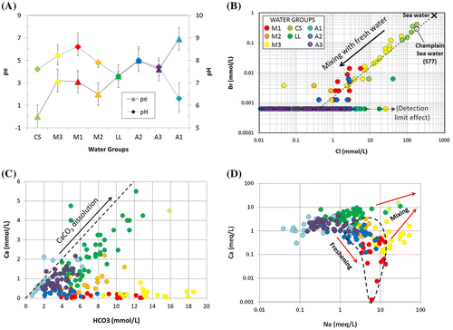
Figure 7. Mixing and relations between water groups and groundwater geochemical end members. A, Samples of water groups defined in Figures and according to the first and second components of the principal component analysis (PCA). B, Relative concentrations of major cations (x-axis) and major anions (y-axis), similar to a Piper plot, supporting relations shown on the PCA graph. Inferred geochemical end members are superposed on both graphs: sea water, lowland recharge, Monteregian water and Appalachian recharge.
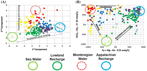
Figure 8. Isotopic composition of groundwater. A, Stable isotopes of groundwater by groups compared to the Basses-Laurentides meteoric water line (BLMWL; Cloutier et al. Citation2006). B, Residence time of water groups indicated by tritium (3H is in tritium units, TU) and radiocarbon (non-corrected 14C ages in years before present, BP). Samples analyzed for only one of the two parameters are still represented in the left and bottom margins of the graph. Ellipses indicate the distribution of samples for water groups.
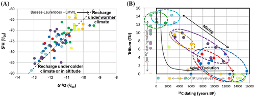
Table 3. Ranges of tritium (3H), uncorrected (lab.) and corrected 14C ages for the water groups.
Figure 9. Geochemical evolution paths and residence time. A, Na/Ca ratio versus uncorrected 14C ages. B, Corrected 14C age range of water groups (Table ). Sample colors are related to water groups as defined in Figures A and .
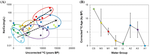
Figure 10. Conceptual model of groundwater geochemical evolution in Montérégie Est. Each of the eight water groups is represented with the direction of evolution (arrows) and the main mechanisms involved (mixing, geological influence, ion exchange) and the corrected radiocarbon age range (see Table ).
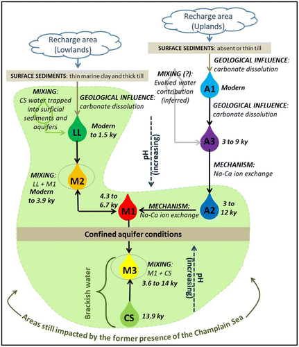
Figure 11. Geochemical conceptual model represented by a schematic cross section from the Appalachian Uplands to the St. Lawrence River. Water group locations are illustrated with associated colors, and flow directions are represented by arrows. The limit of the former Champlain Sea is indicated by dashed lines on the map and section.
