Figures & data
Fig. 1 Map depicting selected latitudinal range and the geographic location of the four FACE field studies in Norby et al. Citation(2005): (1) AspenFACE, (2) ORNL-FACE, (3) DukeFACE and (4) POP-EUROFACE.
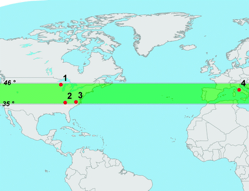
Fig. 2 Distribution of the average NPP increase between 1997 and 2002 under a [CO2]atm of 550 ppm for a) all forests, b) broadleaf trees, c) needleleaf trees, d) C3 grasses, e) C4 grasses and f) shrubs. The latitudinal band between 35°N and 46°N is indicated by the grey shaded area.
![Fig. 2 Distribution of the average NPP increase between 1997 and 2002 under a [CO2]atm of 550 ppm for a) all forests, b) broadleaf trees, c) needleleaf trees, d) C3 grasses, e) C4 grasses and f) shrubs. The latitudinal band between 35°N and 46°N is indicated by the grey shaded area.](/cms/asset/51aa5a72-2426-475f-a7a4-e3c4f6b69b67/tato_a_554784_o_f0002g.jpg)
Fig. 3 Distribution of average NPP increases between 1997 and 2002 with carbon availability equivalent to a [CO2]atm of 550 ppm and excluding the effects of climate change for a) all forests, b) broadleaf trees, c) needleleaf trees, d) C3 grasses, e) C4 grasses and f) shrubs. The latitudinal band between 35°N and 46°N is indicated by the grey shaded area.
![Fig. 3 Distribution of average NPP increases between 1997 and 2002 with carbon availability equivalent to a [CO2]atm of 550 ppm and excluding the effects of climate change for a) all forests, b) broadleaf trees, c) needleleaf trees, d) C3 grasses, e) C4 grasses and f) shrubs. The latitudinal band between 35°N and 46°N is indicated by the grey shaded area.](/cms/asset/e2a6f731-bb4f-4e1b-8c78-790d319c2570/tato_a_554784_o_f0003g.jpg)
Fig. 4 Average percentage global NPP increase of recognized PFTs between 1997 and 2002 at a [CO2]atm of 550 ppm and the C4MIP range of model NPP responses with (black) and without (grey) climate change. The black horizontal lines represent the maxima and minima of the Norby et al. Citation(2005) NPP response range of 21.0% to 25.0%.
![Fig. 4 Average percentage global NPP increase of recognized PFTs between 1997 and 2002 at a [CO2]atm of 550 ppm and the C4MIP range of model NPP responses with (black) and without (grey) climate change. The black horizontal lines represent the maxima and minima of the Norby et al. Citation(2005) NPP response range of 21.0% to 25.0%.](/cms/asset/44a36c4b-5308-4676-9199-c6aa24c84750/tato_a_554784_o_f0004g.gif)
Fig. 5 Average percentage NPP increase of recognized plant functional types between 1997 and 2002 at a [CO2]atm of 550 ppm with (black) and without (grey) climate change but only between 35°N and 46°N latitude (1997–2002). The black horizontal lines represent the Norby et al. Citation(2005) NPP response range of 21.0% to 25.0%.
![Fig. 5 Average percentage NPP increase of recognized plant functional types between 1997 and 2002 at a [CO2]atm of 550 ppm with (black) and without (grey) climate change but only between 35°N and 46°N latitude (1997–2002). The black horizontal lines represent the Norby et al. Citation(2005) NPP response range of 21.0% to 25.0%.](/cms/asset/3bc6f6c3-746d-4a8e-9659-63d5aa6d669e/tato_a_554784_o_f0005g.gif)