Figures & data
Table 1. Description of model simulations.
Fig. 1 Simulated global trend in a) continental runoff, b) land temperature, c) precipitation over land, and d) evaporation over land, in response to the drivers ALL, GG, V-CO2, LCC and AER.
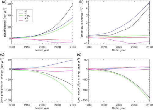
Fig. 2 Simulated northern latitude trend in a) continental runoff, b) land temperature, c) precipitation over land, and d) evaporation over land, in response to the drivers ALL, GG, V-CO2, LCC and AER. The region shown here covers all river basins that drain into the North Atlantic and Arctic oceans north of 45°N latitude and between 105°W and 90°E longitude, as indicated by the shaded box in .
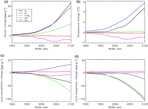
Fig. 3 Spatial distribution of precipitation–evapotranspiration (P–E) change between 1800 and 2100, in response to each driver: a) ALL simulation; b) greenhouse gas forcing; c) vegetation physiological forcing; d) aerosol forcing; and e) land cover change. The grey bounding box represents our selected northern latitude region.
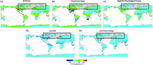
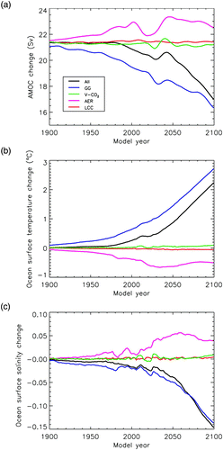
Fig. 4 Simulated trends in a) the Atlantic Meridional Overturning Circulation (AMOC), b) surface ocean temperature changes and c) surface ocean salinity changes in response to drivers ALL, GG, V-CO2, LCC and AER. Surface ocean temperature and salinity values are averaged over the North Atlantic and Arctic oceans, north of 45°N latitude and between 105°W and 90°E longitude.