Figures & data
Fig. 1 Map of model domain showing the major locations and features, bathymetry (in metres). The thick red lines indicate transects where the model volume transports are calculated. A is Merasheen Island; B is Red Island and C is Long Island. D is one of the two tide-gauge stations (red dots).
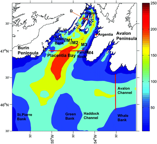
Fig. 2 The horizontal grid used in the numerical model.
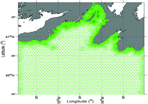
Fig. 3 (a) M2 and (b) K1 co-amplitude (red, in metres) and co-phase (blue, in degrees) charts. The 100 m and 200 m isobaths are displayed as black lines.
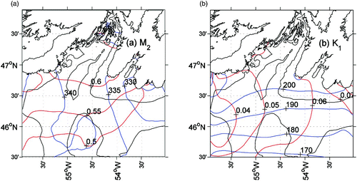
Table 1. Summary and statistics for observed and computed semi-diurnal and diurnal tidal elevations at two coastal tide-gauge stations. AO is the observed amplitude. PO is the observed phase. AMO is the amplitude difference of observed and model results. PMO is the phase difference of observed and model results. See for the location of the tide gauges.
Fig. 4 Near-surface (a) M2 and (b) K1 tidal current ellipses for the entire model domain, with corresponding close-ups (c) and (d) for the bay area. The 100 m and 200 m isobaths are displayed as black lines. Observations are in red. Note that the scales are different among the panels.
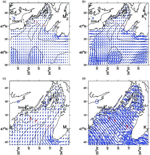
Fig. 5 (a) Wind speed and direction and (b) low-pass (36-hour) filtered sea level anomalies at Argentia from April to June 1999.
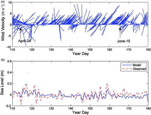
Fig. 6 Time series (36 h low-pass filtered) of observed (red) and modelled (blue) along-bay (U) and cross-bay (V) currents at (a) 20 m for M1, M2, M3 and M4 and (b) at 55 m for M1 and M2 and 40 m for M4.
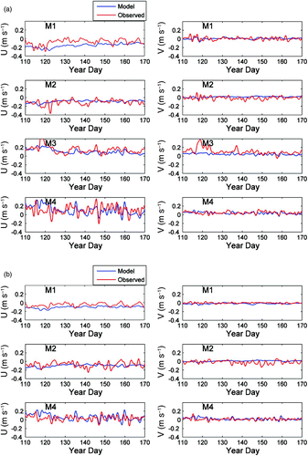
Table 2. Current statistics: along-bay and cross-bay RMS current differences (m s−1), VDR, and SDR at 20 m and 55 m (45 m for M4). See at M1, M2, M3 and M4.
Fig. 7 Observed (red) and modelled (blue) low-pass filtered temperature time series (a) at 10 m, (b) at 30 m, and (c) at 55 m (45 m for M4).
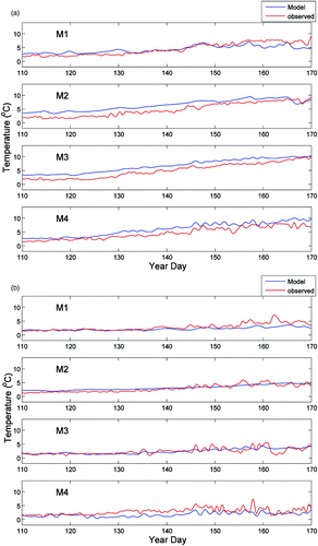
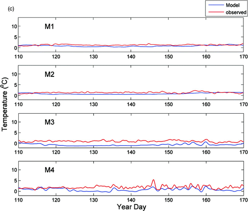
Fig. 8 Comparison of the vertical temperature profile between the model results and observations at M1, M2, M4 and M4 on (a) 24 April and (b) 15 June 1999.
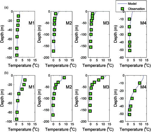
Table 3. Statistics for the comparison of the10 m modelled and observed temperatures at M1, M2, M3 and M4. See for the locations of M1, M2, M3 and M4.
Table 4. Statistics for the comparison of the 30 m modelled and observed temperatures at M1, M2, M3 and M4. See for the locations of M1, M2, M3 and M4.
Table 5. RMS temperature difference between the observed and simulated values at 55 m (45 m at M4). See for the locations of M1, M2, M3 and M4.
Fig. 9 Model surface circulation and temperature (°C) fields at (a) 1800 24 April and (b) 0000 15 June 1999. The corresponding close-ups for the bay area are shown in (c) and (d). The magnitude and direction of the wind (blue arrow) are also shown.
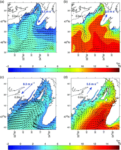
Fig. 10 Five-day satellite SST (°C) images from NOAA during late April (22–26 April) and mid-June (15–19 June) 1999.
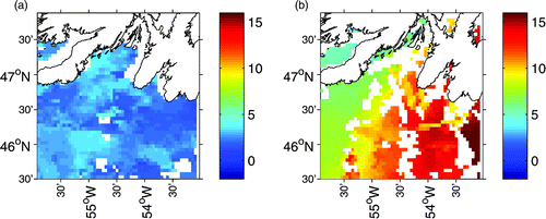
Fig. 11 Modelled transport through (a) western and (b) eastern Placentia Bay at 47°N and (c) the net transport (positive northward). The modelled transport across the Avalon Channel (from the coast to the 90 m isobath on the offshore side of the channel), is also shown in (d) (positive westward). The zero line (red) is also depicted. See for the location of the transects.
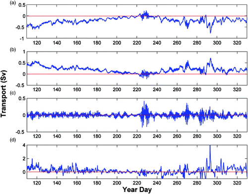
Fig. 12 Depth-averaged (0–10 m) buoyancy frequency squared N 2 and Richardson number (Ri) at (a) M1 and (b) M4 for April–November 1999. In the plots of the Ri time series, the two red lines denote Ri = 1 and Ri = 0.25.
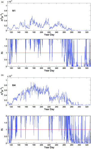
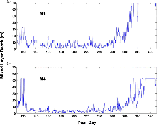
Fig. 13 Mixed-layer depth for (a) M1 and (b) M4.