Figures & data
Fig. 1 (a) Schematic of general upper-ocean circulation over the northwest Atlantic Ocean and the model domain marked by dashed lines (modified from the image created by Igor Yashayaev, reproduced by permission). (b) Topographic features over the eastern Canadian continental shelf. Model results over subregions with different colours are discussed in the paper. Model results over areas marked by P1 and P5 and indicated sections are used for the model validation and the process study of interannual variability. Abbreviations are used for the Gulf Stream (GS), North Atlantic Current (NAC), Labrador Current (LC), Mann Eddy (ME), West Greenland Current (WGC), Baffin Island Current (BIC), Outflow from Hudson Strait (OHS), Labrador Shelf (LS), Newfoundland Shelf (NFS), Scotian Shelf (SS), Gulf of Maine (GOM), Gulf of St. Lawrence (GSL), Slope Water (SW), Grand Banks (GB), Flemish Cap (FC), Flemish Pass (FP), Tail of the Grand Banks (SToGB), Cape Hatteras (CH).
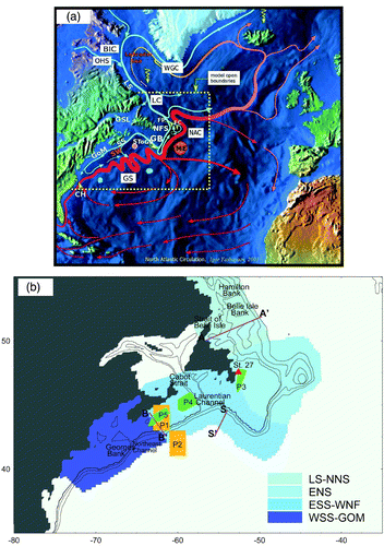
Fig. 2 Time series of monthly temperature anomalies (annual cycle removed) from 1945 to 1992 at (a) Georges Basin at 100 m, (b) the Slope Water region at 100 m. Depth-mean monthly (dashed) and five-year running average (solid) anomalies of temperature at (c) Flemish Cap and (d) Station 27 (modified from Petrie and Drinkwater (Citation1993) by permission of the American Geophysical Union and Colbourne and Foote (Citation2000) by permission of the Northwest Atlantic Fisheries Organization).
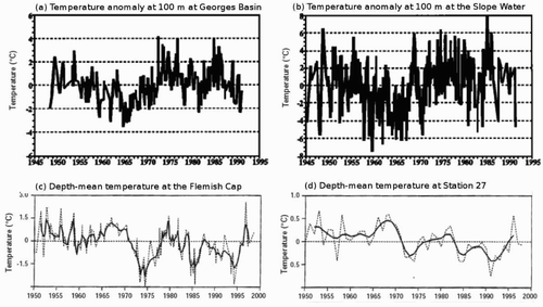
Fig. 3 Time-mean streamfunction of the depth-integrated flow calculated from model currents in the 17-year period 1988–2004 with the arrows indicating the depth-averaged currents over the model domain. The contour interval is 10 Sv and the dashed line represents the 0 Sv contour.
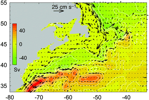
Fig. 4 (a) Comparison of time-mean surface geostrophic currents in the five-year period 2000–04 calculated from the simulated (blue) and altimetry-derived (red) time-mean sea surface elevations (data from Higginson et al. (Citation2011)). (b) Scatterplot of altimetry-derived and simulated time-mean surface geostrophic currents.
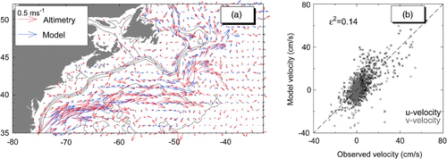
Fig. 5 (a) Comparison of time-mean currents at 15 m inferred from sub-surface drifter movements (data from Niiler (Citation2001)) and computed from 3-D model results (blue) and (b) scatterplot of drifter-derived and simulated time-mean horizontal currents over the northwest Atlantic.
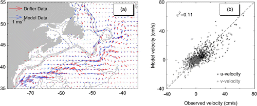
Fig. 6 (a) Absolute geostrophic currents estimated from time-mean hydrographic observations at a transect off the southwestern Newfoundland Shelf at approximately 55°W (reprinted from Pickart and Smethie (Citation1998) by permission of Elsevier). (b) Time-mean currents normal to the transect computed from model results between 1988 and 2004. Black contour lines indicate velocity contours spaced every 1 cm s−1 with the thick black line indicating the zero velocity contour. Abbreviations are used for the Slope Water Jet (SWJ), Upper Labrador Sea Water (ULSW), Classical Labrador Sea Water (CLSW), Denmark Strait Overflow (DSO) and the Gulf Stream (GS).
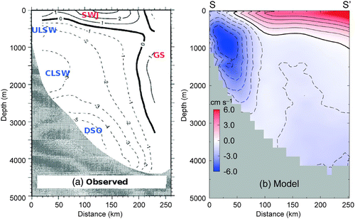
Fig. 7 Colour images showing time-mean temperature (a and c) and salinity (b and d) at depths of 32 and 112 m calculated from 3-D model results between 1988 and 2004. The black contours are the mean absolute differences between the climatological and simulated monthly mean temperature and salinity at the two depths.
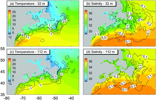
Fig. 8 Monthly mean anomalies of sea surface temperature derived from satellite remote sensing data (Shadwick et al., Citation2010) and calculated from model results for (a) an area over the central Scotian Shelf centred at 44°N and 64°W (P1 in ) and (b) an area over the Slope Water region centred at 42°N and 60°W (P2 in ).
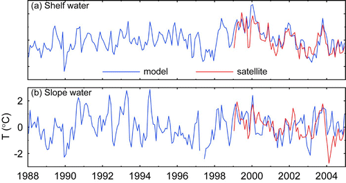
Fig. 9 Comparison of annual mean anomalies of observed hydrography over the Newfoundland and Scotian shelves (data from Head and Sameoto (Citation2007)) with annual mean anomalies from model results for (a) temperature at P3 over the Newfoundland Shelf; (b) temperature at P4 over the eastern Scotian Shelf; (c) temperature at P5 over the central and western Scotian Shelf and (d) salinity at P3 at the Newfoundland Shelf.
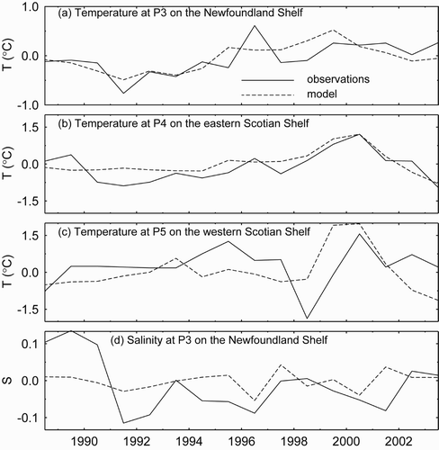
Fig. 10 Monthly mean anomalies of sub-surface (100–300 m) model (a) temperature and (b) salinity at seven locations (marked by solid triangles) along the shelf break of the eastern Canadian Shelf in Exp-Control (solid) and Exp-ConstAll (dashed).
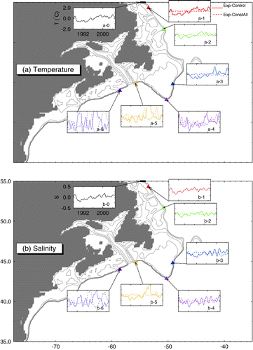
Fig. 11 Correlation coefficients between the monthly mean (a) temperature and (b) salinity anomalies at six different positions along the shelf breaks of the eastern Canadian shelf and the anomalies at the northern open boundary (OB); (c) and (d); as in (a) and (b) but for the correlation coefficients between the temperature and salinity anomalies with the winter North Atlantic Oscillation index (NAO). Different line colours represent the different locations shown in .
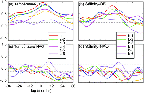
Table 1. Percentages of the total variance explained by the first three CEOFs extracted from the monthly mean temperature and salinity anomalies in the three layers over the Labrador Shelf and northern Newfoundland Shelf in the control run.
Fig. 12 Distributions of spatial amplitude (S 1) and phase (θ1; arrows), temporal amplitude (R 1) and temporal phase change (Δϕ1) of the first CEOF for the monthly mean temperature anomalies at 160 m over the Labrador and northern Newfoundland shelves in Exp-Control (left panels) and Exp-ConstFluxes (right panels). The red line in the bottom panels represents the averaged temporal phase change.
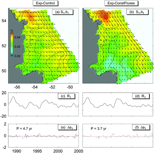
Fig. 13 Vertical distributions of spatial amplitude functions (S 1) of the first CEOF for the temperature (left panels) and salinity (right panels) anomalies in the upper (upper panels), intermediate (middle panels) and lower (lower panels) layers along section AA′ at White Bay on the northern Newfoundland Shelf.
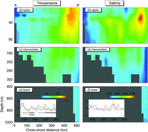
Table 2. Percentages of the total variance explained by the first three CEOFs extracted from the monthly mean temperature and salinity anomalies in the three layers over the eastern Newfoundland Shelf in the control run.
Fig. 14 Distributions of spatial amplitude (S 1) and phase (θ1; arrows), temporal amplitude (R 1) and temporal phase change (Δϕ1) functions of the first CEOF for the monthly mean salinity anomalies at 160 m over the eastern Newfoundland Shelf and adjacent waters in Exp-Control (left panels), Exp-ConstAll (centre panels) and Exp-ConstFluxes (right panels). The red line in the bottom panels represents the averaged temporal phase change.
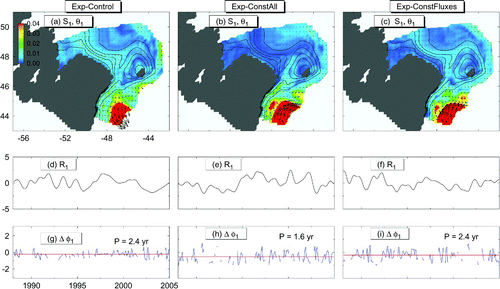
Fig. 15 Distributions of spatial amplitude (S 1) and phase (θ1; arrows), functions of the second (left panels) and third (right panels) CEOFs for the monthly mean temperature anomalies at 160 m over the eastern Newfoundland Shelf and adjacent waters in the control run.
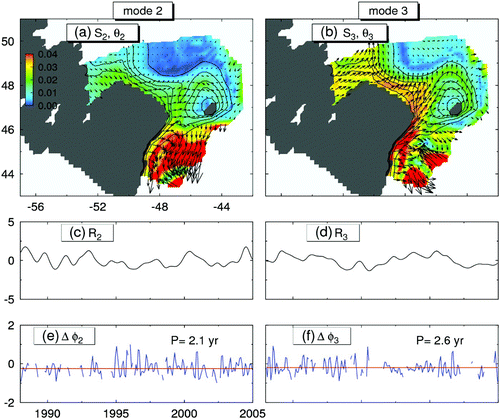
Fig. 16 Temperature anomalies at 160 m over the Scotian Shelf and Newfoundland Shelf region at six different times in 1998–99: (a) 29 March 1998; (b) 18 April 1998; (c) 18 May 1998; (d) 6 August 1998; (e) 14 December 1998; and (f) 4 March 1999. A long-term monthly mean cycle has been removed from the five-day anomalies.
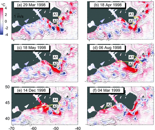
Table 3. Percentages of the total variance explained by the first three CEOFs extracted from the monthly mean temperature and salinity anomalies in the three layers over the subregion of the western Newfoundland Shelf, eastern Scotian Shelf and adjacent waters in the control run.
Fig. 17 Distributions of spatial amplitude (S 1) and phase (θ1;arrows), temporal amplitude (R 1) and temporal phase change (Δϕ1) functions of the first CEOF for the monthly mean temperature anomalies at 160 m over the subregion of the western Newfoundland Shelf, eastern Scotian Shelf and adjacent waters in Exp-Control (left panels) and Exp-ConstFluxes (right panels). The red line in the bottom panels represents the averaged temporal phase change.
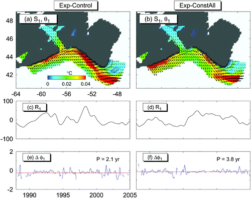
Fig. 18 Vertical distributions of spatial amplitude functions (S 1) of the first CEOF for the temperature (left) and salinity (right) anomalies in the (a and b) upper, (c and d) intermediate and (e and f) lower layers along section BB′ (Halifax Line) on the Scotian Shelf.
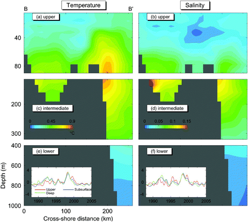
Table 4. Percentages of the total variance explained by the first three CEOFs extracted from the monthly mean temperature and salinity anomalies in the three layers over the subregion of the western Scotian Shelf, the Gulf of Maine and adjacent waters in the control run.
Fig. 19 Distributions of spatial amplitude (S 1) and phase (θ1;arrows), temporal amplitude (R 1) and temporal phase change (Δϕ1) functions of the first (left panels), second (centre panels) and third (right panels) CEOFs for the monthly mean temperature anomalies at 160 m over the western Scotian Shelf and Gulf of Maine region. The red line in the bottom panels represents the averaged temporal phase change.
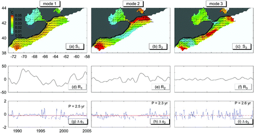
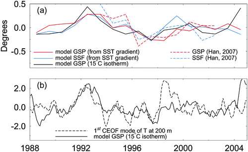
Fig. 20 (a) Simulated annual-mean Gulf Stream (GSP) and shelf-slope front (SSF) position anomalies for the period 1988–2004 based on the methodologies used by Drinkwater et al. (Citation1994) (SST gradients) and by Joyce et al. (Citation2000) (15°C isotherm). Also shown are the GSP and SSF anomalies estimated from remote sensing data (data from Han (Citation2007)) for the period 1992–2003; (b) standardized monthly time series of the first CEOF of temperature over the eastern Scotian Shelf at 200 m and the simulated GSP anomaly estimated from the position of the 15°C isotherm at 200 m depth.