Figures & data
Fig. 1 Map of the Discovery Islands region showing relevant place names, rivers, bodies of water, weather stations, CTD sites, Tide Table sites and the Barnes Bay fish farm.
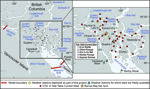
Table 1. a) M2 and b) K1 model tidal elevation amplitudes (cm) and phases (degrees, gmt) versus values arising from tide gauge analyses. Length (days) is the tide gauge time series length while D (cm) is the difference between modelled and observed values in complex space. Tide gauge numbers are consistent with .
Fig. 2 Locations of tide gauges (numbered circles) and current meters (red triangles) used to evaluate model accuracy. Colour contours are bathymetry (m). Current meters are Nodales Channel (NC), Discovery Passage (DP) and Cape Mudge (CM).
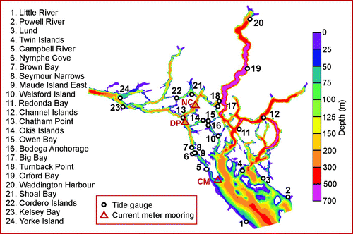
Fig. 3 Horizontal grid and rivers whose discharges were used for the FVCOM simulations.
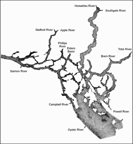
Fig. 4 Original and smoothed bathymetry (m) for a) a Discovery Channel transect through mooring DP and b) an along-channel transect from the lower reaches of the Homathko River into Bute Inlet. Δh/h values denote smoothing criteria.
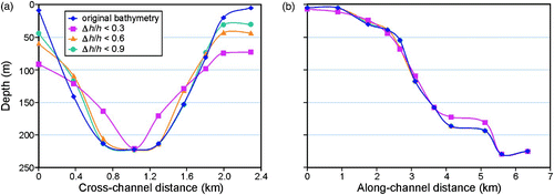
Fig. 5 Initial surface salinity and temperature (°C) interpolated from historical climatology and recent observations at the CTD locations shown in .
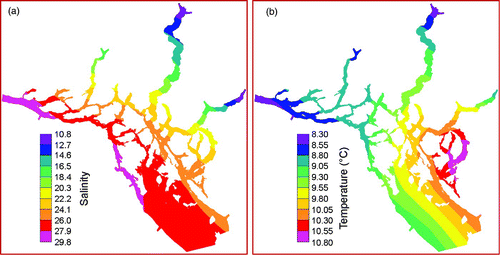
Fig. 6 Winds on 1–28 April measured at the Sentry Shoal, Cinque Islands and Lee Islands weather stations shown in .
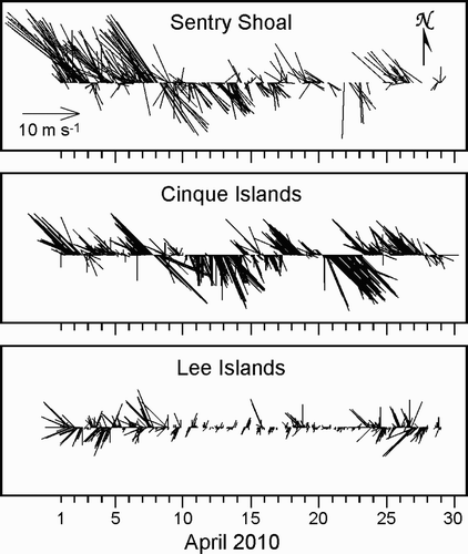
Fig. 7 Daily water temperatures taken at 1 and 15 m depth at the Barnes Bay aquaculture site for the period 1 June 2009 to 30 June 2010. The grey strip denotes the 1–28 April model simulation period.
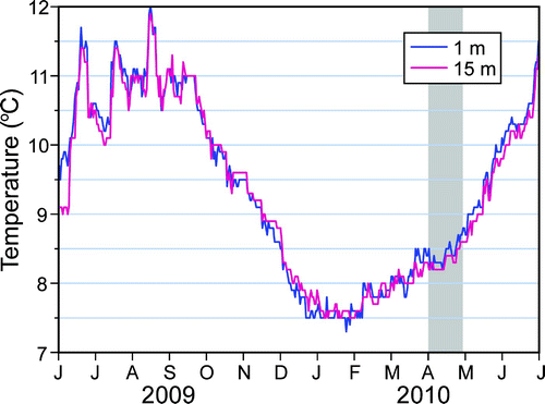
Fig. 8 Discharges for the Homathko, Salmon, Oyster and Campbell rivers (EC, Citation2010b).
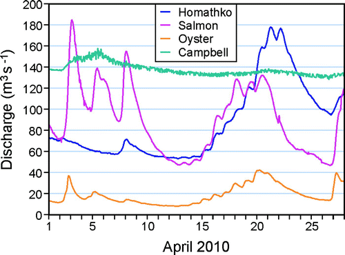
Table 2. Estimated and gauged river discharges for 1 April 2010; e = estimated, g = gauged.
Fig. 9 Model co-amplitudes (cm) for a) M2 and b) K1.
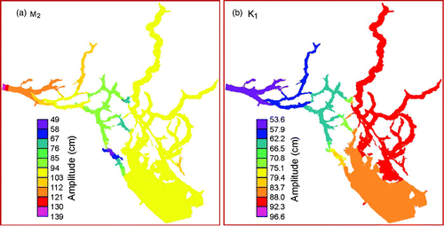
Fig. 10 Mean model surface elevations and flows at 1 m depth computed by harmonic analyses for the period 4–28 April 2010. Only vectors at nodes separated by a minimum of 600 m are shown in the larger region; all vectors are shown in the Seymour Narrows insert.
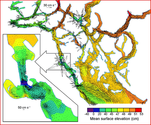
Fig. 11 Maximum surface speeds (m s−1) over the 28-day model simulation period.
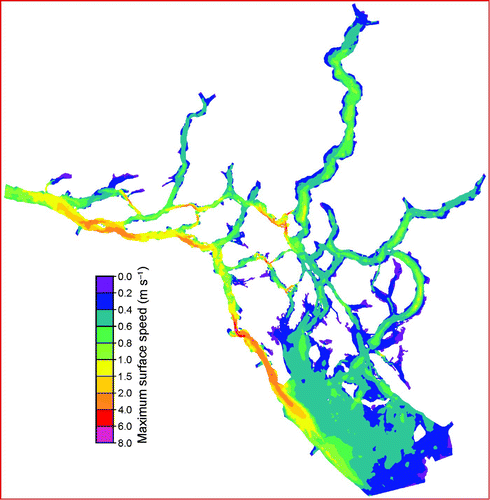
Fig. 12 Observed and modelled vertical profiles of M2 and K1 tidal speed (semi-major axis, cm s−1) at the current meter moorings () in a) Nodales Channel (NC), b) Discovery Channel (DP) and c) Cape Mudge (CM).
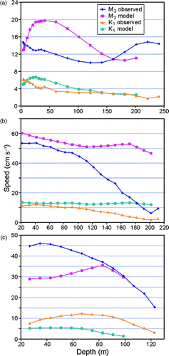
Fig. 13 Observed and modelled mean, “along-channel”, vertical profiles at current meter moorings a) NC, b) DP and c) CM. For CM, “along-channel” was chosen as 160° counterclockwise from east, the angle of inclination of the M2 major semi-axis.
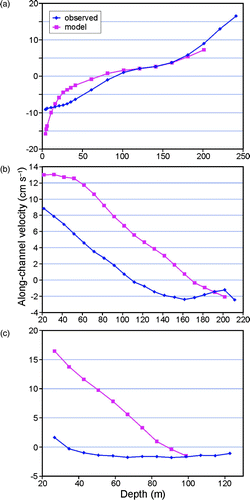
Fig. 14 Observed and modelled low-pass filtered, “along-channel,” currents (m s−1) versus depth for a) DP (positive is 116° counterclockwise from east), b) NC (positive is 57° counterclockwise from east) and c) CM (positive is 155° counterclockwise from east).
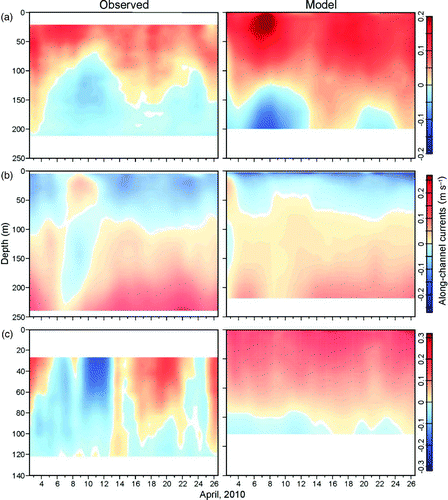
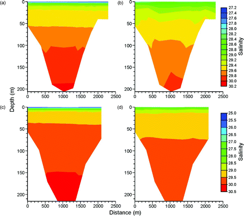
Fig. 15 Model salinities for transects crossing Discovery Channel through mooring DP at a) hour 0 and b) hour 672; and Nodales Channel through mooring NC at c) hour 0 and d) hour 672.