Figures & data
Fig. 1 Average number of Argo profiles per day available in the western North Pacific Ocean for a tropical cyclone as a function of distance from the cyclone centre and time before and after the cyclone passage. The calculation is based on (a) typhoons and (b) all tropical cyclones, respectively.
Fig. 2 Changes in (a) MLD (m) and (b) MLT (°C) observed in Argo profiles during one cycle (7–10 days) as a function of latitude in the typhoon season (May to November) without the influence of a tropical cyclone. The red curves are mean changes, and the red bars are the standard deviations of MLD and MLT at corresponding latitudes.
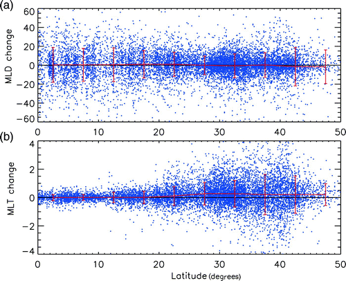
Table 1. Seasonal cycle of MLD and MLT in the western North Pacific Ocean.
Fig. 3 Bar graphs of (a) number of Argo profile pairs, (b) MLD (m) change and (c) MLT (°C) change as a function of the distance from the typhoon centre. Negative (positive) distance means that the Argo profiles are located on the left (right) side of the typhoon track; the changes on the right of the track are in blue. Argo profiles within five days of a typhoon passage are counted. The error bars (black) in (b) and (c) are calculated as the standard deviation divided by the square root of the number of data pairs.
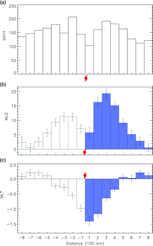
Fig. 4 As in but as a function of time. Negative (positive) time means the Argo profiles observed before (after) the typhoon passage; the MLD and MLT changes after the typhoon passage are in blue. Argo profiles within 300 km of the typhoon track are counted. The error bars are shown in (b) and (c) in black.
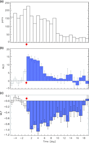
Fig. 5 (b)–(d) as in (a)–(c) but as a function of latitude; (a) shows the climatological MLD during the typhoon season (May to November) without the influence of typhoons. Argo profiles within 5 days of a typhoon passage and 300 km from the typhoon track are counted. The error bars are shown in (c) and (d) in black.
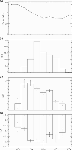
Fig. 6 As in but as a function of typhoon translation speed. Argo profiles within 300 km of a typhoon track and within five days of a typhoon passage are counted. The columns in blue indicate translation speeds less than 4 m s−1. The first column is for translation speeds less than 2 m s−1, and the last column is for translation speeds greater than 11 m s−1. The error bars are shown in (b) and (c) in black.
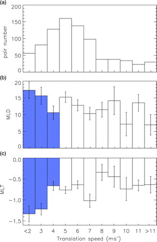
Fig. 7 (a) Percentage of typhoons moving at different speeds for the period 2000 to 2008. The solid curve shows all tropical cyclones and the dashed curve only typhoons. (b) The average wind speed of tropical cyclones (solid line) and typhoon translation speed (dashed line) as a function of latitude.
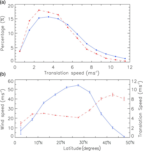
Fig. 8 Centre locations of pre-existing warm-core (red, SSHA >6 cm) and cold-core (blue, SSHA <−6 cm) circulation features before a typhoon passage.
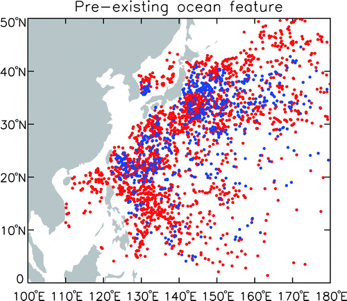
Fig. 9 (a)–(c) as in (a)–(c) but as a function of pre-existing oceanic conditions. The columns in blue are for cold-core circulations and the white columns are for warm-core circulations. Argo profiles within 300 km of a typhoon track and five days of a typhoon passage are counted. A Student's t-test shows that the MLD and MLT changes under cold-core conditions are significantly different from those under warm-core conditions. (d) Composites of Argo temperature profiles for cold-core circulations (blue) and warm-core circulations (red). The solid (dotted) curves denote profiles before (after) a typhoon passage.
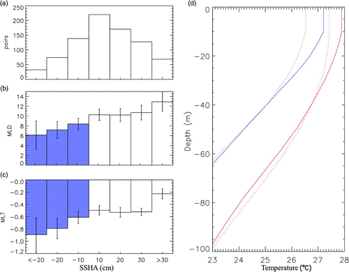
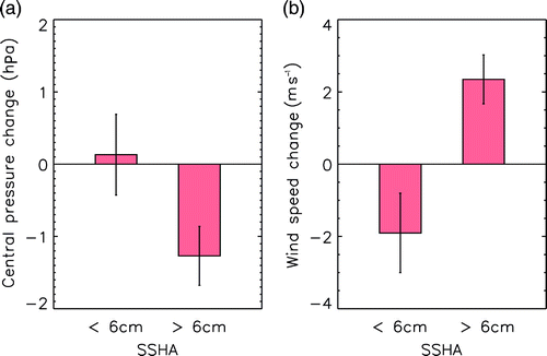
Fig. 10 Average changes in (a) central pressure and (b) maximum sustained wind speed one day after the eye of a typhoon passes over warm-core (SSHA >6 cm) and cold-core (SSHA <−6 cm) mesoscale features.