Figures & data
Fig. 1 The Queen Elizabeth Islands (QEI) located in the northern region of the Canadian Arctic Archipelago. The northwestern QEI flux gates as defined in other studies are Ballantyne Strait, Wilkins Strait and the Prince Gustaf Adolf Sea (QEI-South) and Peary Channel and Sverdrup Channel (QEI-North). The Prince Gustaf Adolf Sea flux gate defined in Kwok (Citation2006) and Agnew et al. (Citation2008) is indicated with a black dashed line in the inset. The locations of the ice island fragments bearing CIS satellite-tracked beacons during the week of fast ice breakup (the last week of July 2010) and prior to entry into the QEI are indicated by red (#47560) and blue (#47554) squares. The location of the Isachsen weather station, on the west coast of Ellef Ringnes Island, is shown in the inset.
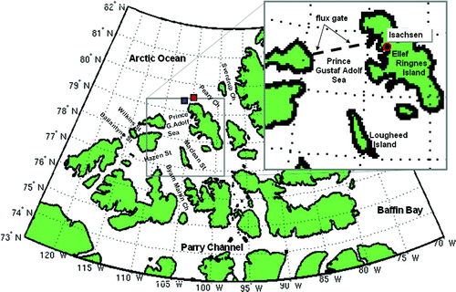
Fig. 2 Weekly evolution of sea-ice conditions within the QEI during 2010. Following the break-up of the fast ice in late July/early August, an initial sudden loss of MYI (right axis) is observed as a result of ice draining southward out of the region. This is followed by periodic intrusions of Arctic Ocean MYI into the QEI resulting in a net increase in total ice over time. The seasonal first-year ice (FYI; left axis), on the other hand, is observed to decrease gradually throughout the melt season and then is rapidly replenished after mid-October by in situ freezing.
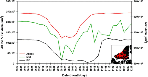
Fig. 3 NOAA AVHRR visible images, showing sea-ice cover in the QEI and the outflow of sea ice from the region through Byam Martin Channel into western Parry Channel during August and early September 2010. Pink arrows illustrate the trajectory of the outflowing sea ice.
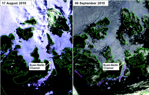
Fig. 4 Time series of RADARSAT-2 images for the period 31 July to 10 September 2010, showing the influx of sea ice from the Arctic Ocean into the Prince Gustaf Adolf Sea in the QEI. The yellow dashed line denotes the leading edge of the intruding Arctic pack ice, which is lighter in tone than the ice in the QEI partly because of a greater concentration of multi-year ice but mainly because of greater ridging and crushing of the Arctic pack ice as a result of its constant mobility throughout the winter months. The large blue arrow shows the direction and extent of the intrusion. RADARSAT-2 Data and Products © MacDONALD, DETTWILER AND ASSOCIATES LTD. (2010) – All Rights Reserved. RADARSAT is an official mark of the Canadian Space Agency.
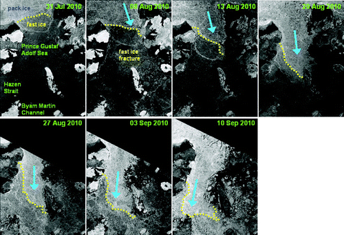
Fig. 5 A time series of NOAA AVHRR infrared images showing the progression of fast ice formation in the corridor between the Prince Gustaf Adolf Sea and Byam Martin Channel (highlighted with a pink dashed line) in 2010. Yellow-orange arrows indicate the direction of ice drift.
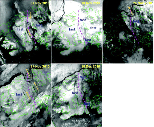
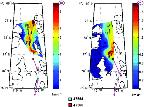
Fig. 6 a) The tracks of two ice island fragments bearing Canadian Ice Service satellite-tracked beacons #47560 (red) and #47554 (blue) that entered the QEI in August 2010 through the Prince Gustaf Adolf Sea. b) Latitudinal or meridional velocity component of the ice island fragments during their track southward through the QEI.
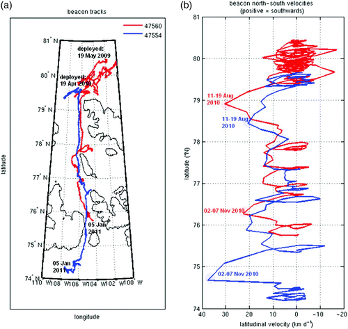
Fig. 7 RADARSAT-derived average ice drift velocities for the period 31 July to 10 September 2010, based on the successive pairs of images shown in . The vector colours represent the confidence levels, determined by prescribed image cross-correlation coefficient thresholds, where green is high and red is low. The vectors are plotted on the first of the two images in a given pair and are shown for the image resolution (200,400 or 800 m pixel−1) which produced the best correlations (and thus vector numbers and confidence levels). RADARSAT-2 Data and Products © MacDONALD, DETTWILER AND ASSOCIATES LTD. (2010) – All Rights Reserved. RADARSAT is an official mark of the Canadian Space Agency.
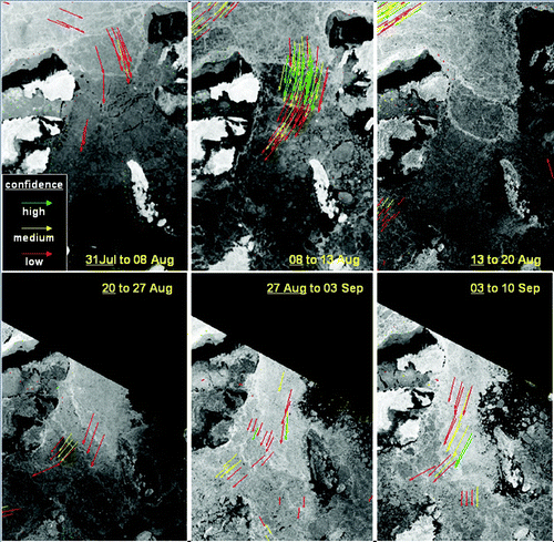
Fig. 8 RADARAT-derived average ice drift velocities for August 2010: a) 8–13 August, a 5-day period which captured the beginning of the first large Arctic sea-ice influx into the QEI through the Prince Gustaf Adolf Sea flux gate; b) 11–13 August, a 2-day period leading into the peak of the influx pulse, which occurred around mid-August; c) 27 August to 3 September, a 7-day period following the mid-August influx pulse as it tapered off towards the end of August. The length of the arrows in the plots is proportional to the total displacement of ice features between the two image times. The speed of the ice motion is indicated by the coloured contours. The leading ice island fragment (beacon #47554, light blue square) passed through the Prince Gustaf Adolf Sea flux gate (i.e., crossed the line between Borden Island and Ellef Ringnes Island as defined in the literature) between the 12 and 14 August 2010.
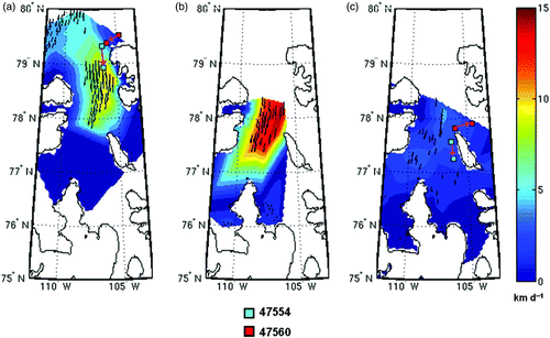
Fig. 9 RADARSAT-derived average sea-ice motion for September 2010: a) 3–10 September, a second wind-driven influx event through the Prince Gustaf Adolf gate occurred during this 7-day period; b) 10–22 September, the two weeks spanning the peak of the Arctic melt season; and c) 22–26 September, a weak burst of northerly winds occurred at the onset of freeze-up in the QEI. The length of the pink arrows in panels a) and b) denoting the direction of motion of beacon #47554 were exaggerated in these plots for the sake of clarity.
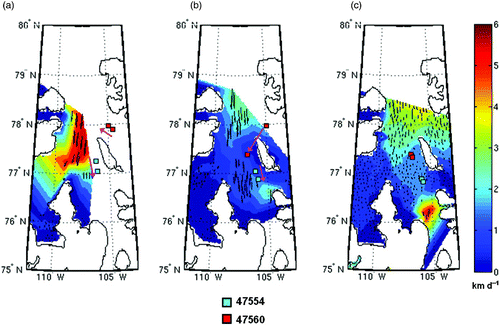
Fig. 10 Time series of mean hourly wind speed (km h−1) at Isachsen station, on the west coast of Ellef Ringnes Island, spanning July to mid-December 2010. Wind data with a northerly directional component are blue in the plot; wind data with a southerly directional component are red. The dates of significant wind events with a northerly component are noted.
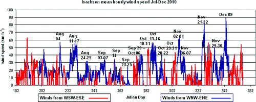
Fig. 11 Temporal and spatial details of the ice drifts associated with a weak burst of northerly winds at the end of September (22–26 September; c): a) and b) ice drifts into the Prince Gustaf Adolf Sea computed from two sets of RADARSAT-1/RADARSAT-2 images spanning 22–24 September; c) and d) ice drifts into the Prince Gustaf Adolf Sea computed from two sets of RADARSAT-1/RADARSAT-2 images spanning 24–26 September. The flux gate defined in Kwok (Citation2006) and Agnew et al. (Citation2008) is indicated by a black dashed line. The positions of beacons 47554 (cyan squares) and 47560 (red squares) on the 22 and 26 September are shown in panels b) and d).
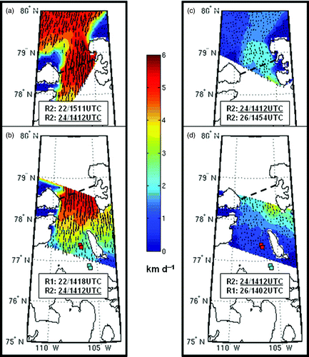
Fig. 12 RADARSAT-derived sea-ice motion from imagery acquired in November and December 2010: a) 1 to 6 November, the week which experienced the last significant wind-driven influx event of the season; and b) 1 November to 13 December, the month spanning the final freeze-up and formation of fast ice in the QEI which experiences a significant slow-down and finally a cessation in ice motion. Note the difference in the magnitudes of the velocity scales of the two panels.