Figures & data
Fig. 1 Temperature (°C) and oxygen percentage saturation measured at the ocean bottom in 100 m of water near Folger Passage, BC, at 48.814°N, 125.281°W (see map in b for location). Instrument and data are maintained by NEPTUNE Canada.
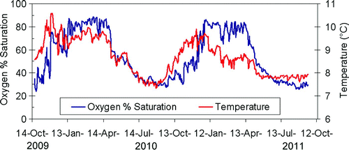
Fig. 6 (a) High-resolution map of the bathymetry off southwest Vancouver Island. Bottom contours are in metres. A blue circle marks the general location of the Juan de Fuca Eddy. (b) Near-bottom oxygen concentrations (ml L−1) off southwest Vancouver Island. Tully Canyon is marked by an open black arrow pointed to the north. The LB line of stations is marked by a black line. A solid black arrow points to Station LB08. The oxygen recorder of NEPTUNE Canada in Folger Passage is at the location marked by a black square.
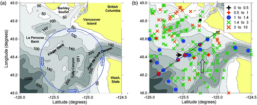
Fig. 2 Measurements of oxygen percentage saturation on the 26.5 σθ surface, June to September, based on archived data. The solid grey line marks the 200 m depth contour. Each symbol represents a distinct measurement.
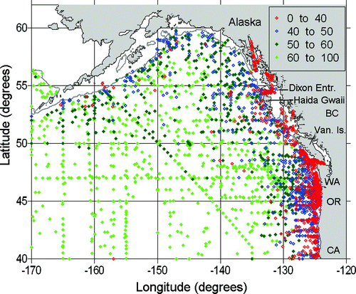
Fig. 3 Historical observations of oxygen concentration (ml L−1) within 20 m of the ocean bottom plotted on maps of the BC shelf and inlets, for the months of June to September. (a) northern BC; (b) southern BC. Depth contours are in metres. Straight black lines pass along the LB and LG lines. Station P4 is marked by a star.
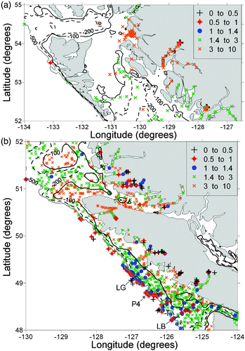
Fig. 4 Contours of (a) oxygen concentration (ml L−1) and (b) σt along the LB line off southwest Vancouver Island in September of 2005 to 2007. Triangles mark the deepest measurements at station locations, with LB01 closest to shore and LB16 farthest offshore. Contouring extends to the deepest measurement not to the ocean bottom. LB08 is marked by a circle enclosing the triangle. Horizontal distance is measured in kilometres seaward of station LB01. Pressure is dbars.
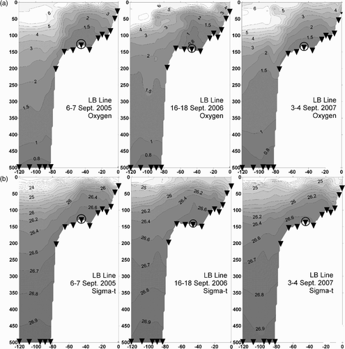
Fig. 5 Contours of (a) oxygen concentration (ml L−1) and (b) σt along the LG line off southwest Vancouver Island in September of 2005 to 2007. Triangles mark the deepest measurements at station locations, with LG01 closest to shore and LG09 farthest offshore. Contouring extends to the deepest measurement not to the ocean bottom. Horizontal distance is measured in kilometres seaward of Station LG01. Pressure is dbars.
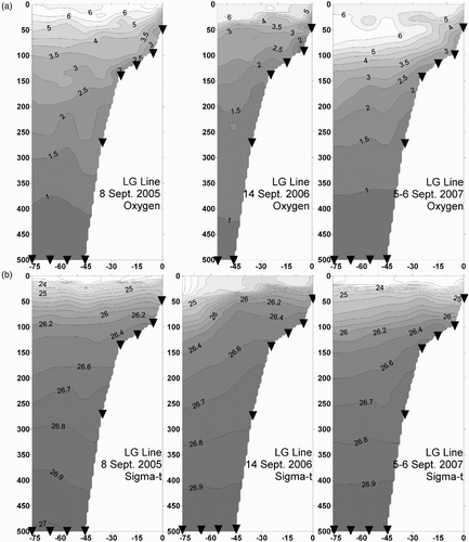
Fig. 7 Near-bottom oxygen concentration (ml L−1) in June 1985 on the continental shelf of southwest Vancouver Island. Different symbols denote stations inside and outside a radius of 20 km from the eddy centre.
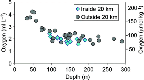
Fig. 8 Results of a numerical model for the continental shelf of southwest Vancouver Island. All panels present vectors of average near-bottom current with the speed scale at bottom left. (a) Contours of bottom depth (m). (b) Contours of near-bottom nitrate concentration (μmol L−1) for the no-biology run where all biological processes are turned off. (c) Contours of near-bottom nitrate concentration (μmol L−1) for the base run where all the biological source and sink terms are computed. (d) Contours of near-bottom nitrate concentration (μmol L−1) obtained by subtracting nitrate concentrations from the no-biology run to the base run (nitrate in panel (c) minus nitrate in panel (b)).
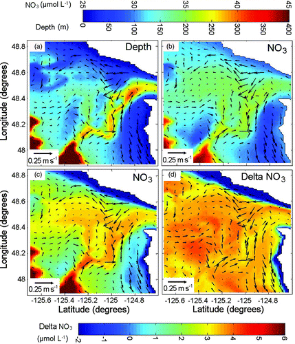
Fig. 9 Near-bottom oxygen concentrations in southern BC from May to September plotted against the year of observation (y-axis) and depth of the ocean bottom in metres (x-axis). Oxygen concentrations (ml L−1) were determined by titrated water samples from hydro-bottles for the years 1934 to 2009 and electronic sensors after 2004. Only observations within 20 m of the ocean bottom are included.
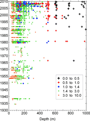
Fig. 10 Oxygen (ml L−1) and nitrate (μmol kg−1) near bottom at Station LB08, 1978 to 2011. (a) Oxygen concentration versus day of year; (b) comparison of nitrate and oxygen concentrations. The black line has a slope of 9.
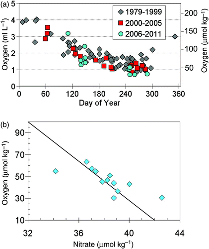
Fig. 11 Oxygen and σt at station LB08 observed between days 241 (29 August) and 289 (16 October) from 1979 to 2011. (a) Oxygen versus year of observation. (b) σt versus year of observation. (c) Oxygen versus σt . Observations for (a) and (b) were averaged within each year prior to plotting. Colours denote depth of observation.
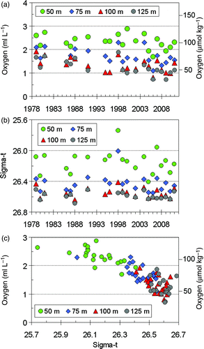
Fig. 12 Oxygen concentration (ml L−1) at 125 m depth at LB08 versus year from the same profiles plotted in a.
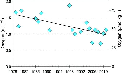
Fig. 13 Oxygen and σt at station P4 observed between day of year 221 and 272 from 1960 to 2011. (a) Oxygen versus year of observation. (b) σt versus year of observation. (c) Oxygen versus σt . Observations for (a) and (b) were averaged within each year prior to plotting. Colours denote depth of observation.
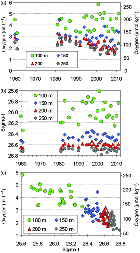
Fig. 14 Temperature-salinity diagram for stations sampled along the LB Line in September 2009. The inset at bottom right shows an enlarged view of the water properties at the bottom of LB08 and at neighbouring LB stations.
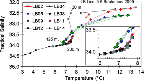
Table 1. Temperature, practical salinity, and σt averaged over all samples collected from late August to late October at specific depths at LB08 and P4, compared to the nominal values computed for Pacific Equatorial Water at 200 m depth west of Vancouver Island, as determined from Thomson and Krassovski (2010; TK2010).
Table 2. Comparison of changes in time of oxygen concentrations and trends at constant depth at various locations along the west coast of the United States and Canada, and at Ocean Station P in the Gulf of Alaska. Rates for Koslow et al. (Citation2011) were determined from of their paper. Gwaii Hanas is the present name for the Queen Charlotte Islands off the northwest British Columbia coast.
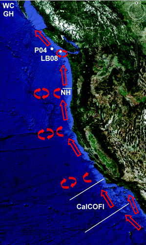
Fig. 15 Pathway of the California Undercurrent and sub-surface eddies formed along its flow (red arrows). The white labels indicate the locations of the studies listed in .