Figures & data
Fig. 1 Regional averaged monthly ⟨Q 1> over the Tibetan Plateau (TP) in 1979−2001 (units are W m−2). The solid line with open circles indicates the ERA-40 result and the solid line with solid circles indicates the NCEP-I result.
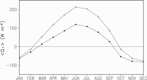
Fig. 2 The seasonal variation of the vertical distribution of mean Q 1 over the TP (altitude ≥3000 m), averaged over the period 1979–2001 (units are K d−1).
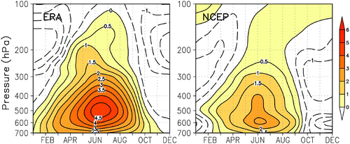
Fig. 3 The monthly mean vertical profile (K d−1) of Q 1 over the TP (altitude ≥3000 m) between March and September of 1979 to 2001. Solid line: calculated value based on ERA-40 data, dashed line: calculated value based on NCEP-I data.
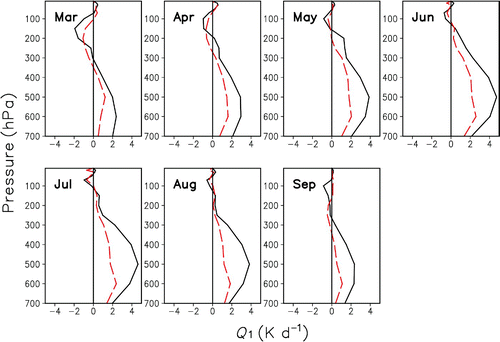
Fig. 4 The monthly mean latent heat profile (K d−1) over the TP (altitude ≥3000 m) for 1998−2006.
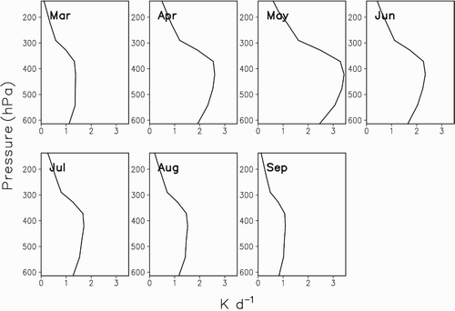
Fig. 5 The monthly mean vertical profile of Q 1 over the TP (altitude ≥3000 m) in 1998 (solid line: ERA-40 calculated value; dashed line: NCEP-I calculated value).
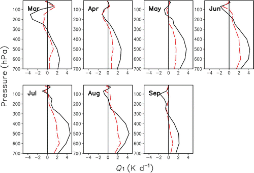
Fig. 6 The monthly mean vertical profile of the rate of latent heating based on 3A12 data on the TP (altitude ≥3000 m) in 1998 (units are K d−1).
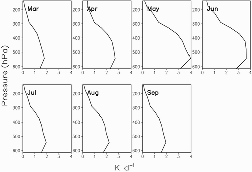
Fig. 7 (a) The daily mean vertical profile of Q 1 (K d−1) and (b) the relative humidity (%) from 4 to 14 June 1998; (c) the vertical profile of latent heat (K d−1) in June 1998 over Anduo station.
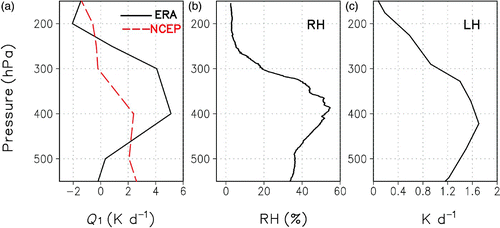
Table 1. The precipitation at Anduo station from 4 to 14 June 1998 (units are millimetres).
Fig. 8 The comparison between the relative humidity and the Q 1 profile over Anduo station from 7 to 9 June 1998. (a) RH (%), (b) ERA-40 (K d−1), and (c) NCEP-I (K d−1).
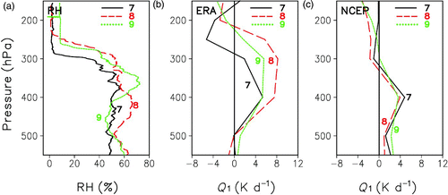
Fig. 9 The comparison between relative humidity and the Q 1 profile over Anduo station from 10 to 12 June 1998. (a) RH (%), (b) ERA-40 (K d−1), and (c) NCEP-I (K d−1).
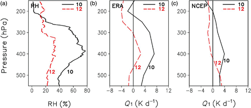
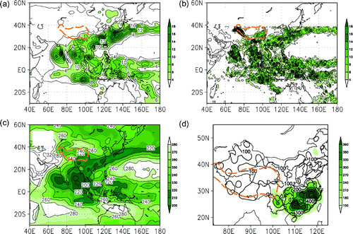
Fig. 10 The distribution of average ⟨Q 1⟩ in summer (June to August) from 1979 to 2001 (units are W m−2). The orange dashed curve indicates the Tibetan Plateau area: (a) ERA-40 data calculation result, (b) NCEP-I data calculation result, and (c) the correlation of the ERA-40 data calculation result and the NCEP-I data calculation result. (Those correlation coefficients beyond the 95% confidence level, based on the Student's t-test, are shaded; the contour interval is 0.1.)
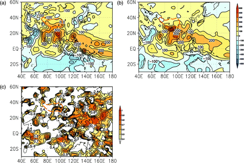
Fig. 11 (a) the GPCP precipitation distribution in summer from 1979 to 2001, (b) the 3A12 precipitation distribution in summer from 1998 to 2006, (c) the OLR distribution in summer from 1979 to 2001, and (d) the summer precipitation in China from 1979 to 2001.
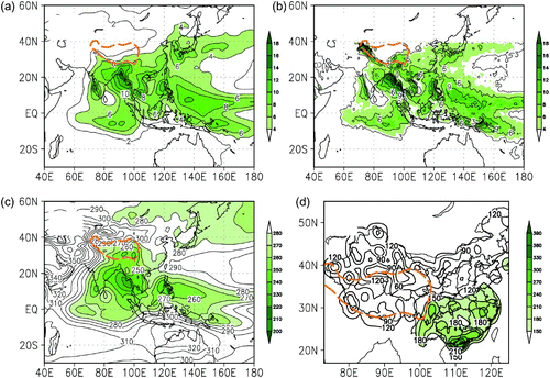
Fig. 12 The horizontal distribution of average ⟨Q 1⟩ in June 1998 (units are W m−2): (a) calculation result based on ERA-40 data and (b) calculation result based on NCEP-I data.

Fig. 13 (a) The distribution of the GPCP precipitation, (b) the 3A12 precipitation, (c) the OLR precipitation, and (d) precipitation in China in June 1998.