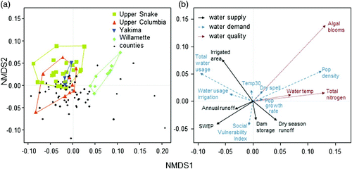
Figures & data
Fig. 1 Study area (outlined in red): five states and 104 counties, main rivers, and elevation.
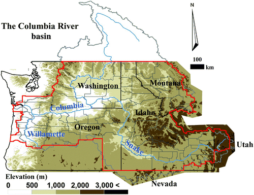
Table 1. Water vulnerability indicators, descriptions, and their sources.
Fig. 2 Vulnerability of (a) water supply, (b) water demand, and (c) water quality, which are normalized to range from 0 to 100. The colour legend shows the same number of counties in each quintile (20%) for each indicator.
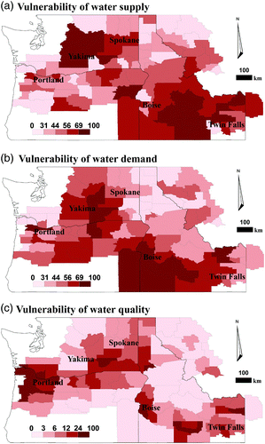
Fig. 3 Spatial cluster maps of three vulnerability indices using univariate LISA analysis with GeoDa (Arizona State University, Citation2012) High-High (Low-Low), a county with a high (low) value surrounded by counties with high (low) values, Low-High (High-Low), a county with a low (high) value surrounded by counties with high (low) values. High-High and Low-Low (Low-High and High-Low) pertain to positive (negative) spatial autocorrelation indicating spatial clustering of similar (dissimilar) values. High-High (red) refers to the hotspot and Low-Low (blue) refers to the cold spot.
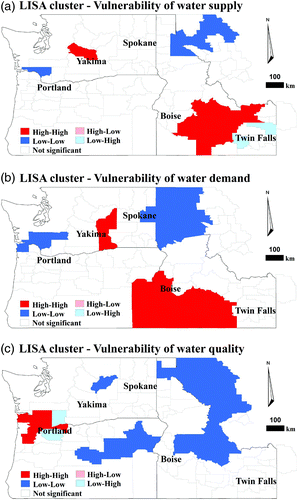
Fig. 4 Water supply vulnerability indicators normalized to range from 0 to 100. (a) Mean annual runoff and (b) total dam storage are rescaled using Eq. (2). The colour legend shows the same number of counties in each quintile (20%) for each indicator.
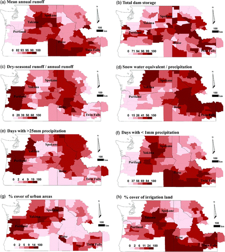
Fig. 5 Water demand vulnerability indicators normalized to range from 0 to 100. The colour legend shows the same number of counties in each quintile (20%) for each indicator.
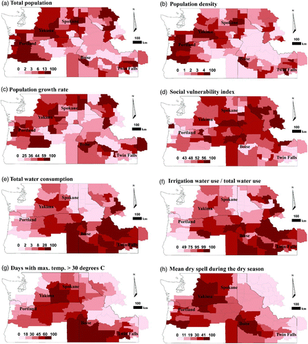
Fig. 6 Water quality vulnerability indicators normalized to range from 0 to 100. The colour legend shows the same number of counties in each quintile (20%) for each indicator.
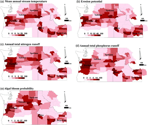
Fig. 7 Relation among vulnerability of water supply (x-axis), vulnerability of water demand (y-axis), and vulnerability of water quality (size of circle). The greyscale shows the ranges in (a) elevation, (b) annual precipitation, (c) impervious area, and (d) proportion of groundwater use to total water withdrawal. Categories for each plot were determined by taking the 33rd and 67th percentile values. For example, the 33rd percentile for elevation is 851 m, whereas the 67th percentile is 1362 m.
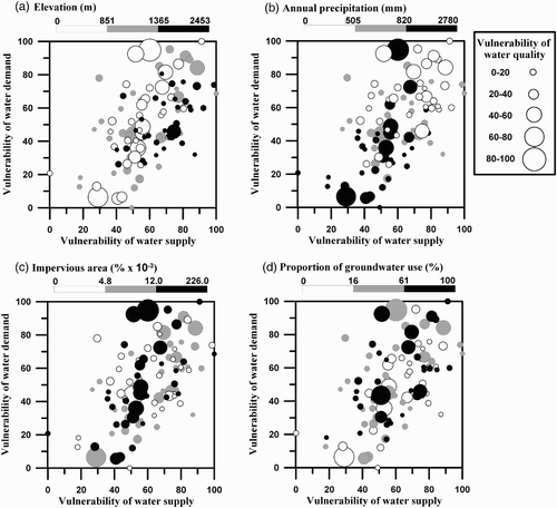
Fig. 8 Non-metric multidimensional scaling on water vulnerability variables in each county. In (a), the site scores for counties (black), highlighting counties in the Upper Snake (yellow squares), Upper Columbia (orange triangles), Yakima (blue inverted triangles), and Willamette (green diamonds) River basins. In (b), water vulnerability variables are shown as water supply (black), water demand (dashed blue), and water quality (dotted red). Panels separated simply for illustration, as are polygons drawn around counties of interest. See for descriptions of variables in (b). Counties that are closer together in multidimensional space are similar in terms of water vulnerability variables whereas counties that are farther apart are dissimilar. For example, counties in the Willamette River basin are tightly clustered, therefore, have similar water resource vulnerability, which coincides with higher values of algal blooms and population density (in the same quadrant in panel (b)). Abbreviations: Pop = population, Temp30 = number of days when maximum air temperature exceeds 30°C, SWEP = ratio of peak snow water equivalent (SWE) to October–March precipitation.