Figures & data
Fig. 1 This study examined seven principal tributary basins within the Columbia River system above Portland, Oregon. For each tributary basin, a paired climate and streamflow record was identified in the headwaters of the basin, and a series of gauges was identified downstream from that headwaters. The study asked two questions. (1) How has streamflow changed in headwater basins, given the climate change signal imposed locally? (2) How do the changes in streamflow in the headwater basin compare to those downstream of dams (indicated by triangles)?
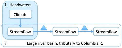
Fig. 2 Columbia River basin, showing locations of climate stations, stream gauges, and dams in the seven sub-basins examined in this study (a) overview of Columbia River basin showing seven sub-basins, (b) Willamette River (W), (c) Entiat River (E), (d) Priest River (P), (e) Bruneau River (B), (f) Pend Oreille River (O), (g) Salmon River (S), and (h) Snake River (S). Codes are one-letter basin abbreviation and number of gauge, from headwaters to downstream.
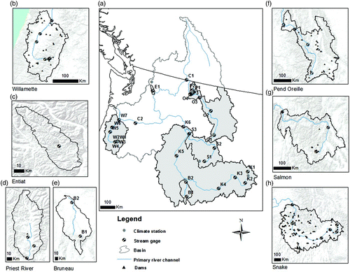
Table 1. Key characteristics of sub-basins of the Columbia River examined in this study.
Table 2. Climate station elevation and record length in headwaters of seven sub-basins of the Columbia River.
Table 3. Basin size and record length for gauges in seven sub-basins of the Columbia River in this study.
Fig. 3 Mean annual flow at gauges from headwaters to downstream in sub-basins in the study (a), and hydrographs and hyetographs from each sub-basin. (b) Bruneau River, (c) Entiat River, (d) Snake River, (e) Pend Oreille River, (f) Priest River, (g) Salmon River, (h) Willamette River. Hyetographs are mean daily precipitation shown on inverted scale. Hydrographs are mean daily flow. See and for station and gauge information.
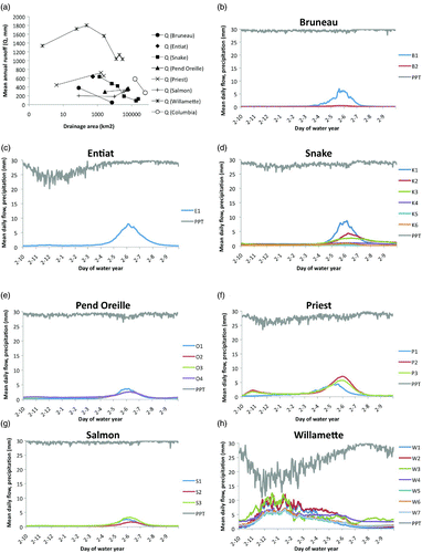
Fig. 4 Changes in daily temperature (T) ((a), (b), and (c)); precipitation (P) ((d), (e)), and streamflow (Q) ((f) to (i)) in the Bruneau River basin. (a), (d), (f), and (g) Daily average (T, P) or median (Q) values for each day of the water year from the first decade of record (grey line) and the last decade of record (black line). Black Xs (for Max T, P, Q) and grey Xs (for Min T) above the line graphs indicate days which experienced significant changes (p < 0.05) based on regression analysis. (b), (c), (e), (h), and (i) Scatter plots of daily average (T, P) or median (Q) values for the entire period of record (x-axis) versus the change from the first decade to the last decade (y-axis). Open grey circles are values for all days (n = 365); closed black circles represent days with significant changes (p < 0.05) based on regression analysis. Units are °C for T, and mm for P and Q. P and Q data were log-transformed prior to linear regression. Both B1 and B2 are upstream of a dam. Basin sizes, and characteristics and names and locations of meteorological stations and gauges are given in to .
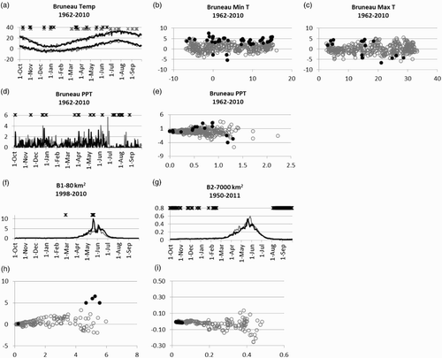
Fig. 5 Changes in daily temperature (T) ((a), (b), and (c)); precipitation (P) ((d), (e)), and streamflow (Q) ((f), (g)) in the Entiat River basin. (a) to (g) Same as in . There are no dams on the Entiat.
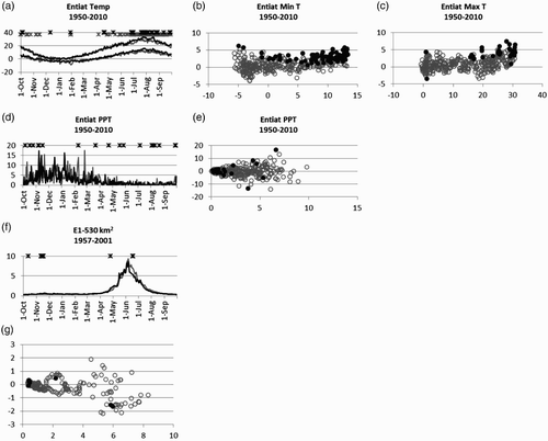
Fig. 6 Changes in daily temperature (T) ((a), (b), and (c)); precipitation (P) ((d), (e)), and streamflow (Q) ((f) to (q)) in the Snake River basin. (a) to (q) Same as in . K1 is upstream of dams; K2 to K6 are downstream.
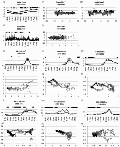
Fig. 7 Changes in daily temperature (T) ((a), (b), and (c)); precipitation (P) ((d), (e)), and streamflow (Q) ((f) to (m)) in the Pend Oreille River basin. (a) to (m) Same as in . All stations are downstream of dams.
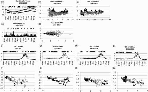
Fig. 8 Changes in daily temperature (T) ((a), (b), and (c)); precipitation (P) ((d), (e)), and streamflow (Q ) ((f) to (k)) in the Priest River basin. (a) to (k) Same as in . P1 is upstream of dams; P2 and P3 are downstream of dams.
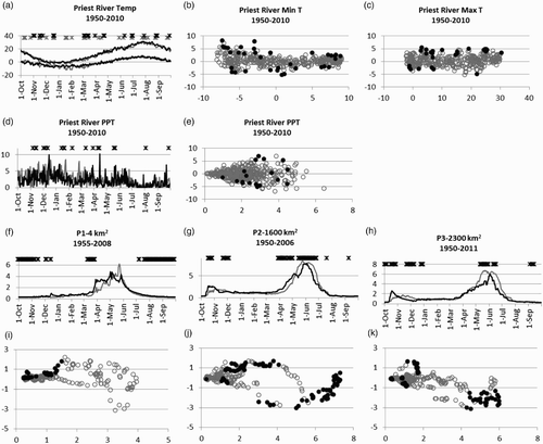
Fig. 9 Changes in daily temperature (T) ((a), (b), and (c)); precipitation (P) ((d), (e)), and streamflow (Q) ((f) to (k)) in the Salmon River basin. (a) to (k) Same as in . S1 is upstream of dams; S2 and S3 are downstream.
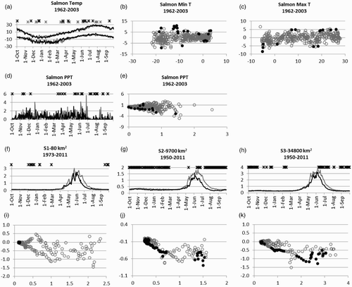
Fig. 10 Changes in daily temperature (T) ((a), (b), and (c)); precipitation (P) ((d) and (e)), and streamflow (Q) ((f) to (s)) in the Willamette River basin. (a) to (s) Same as in . W1 and W2 are upstream of dams; W3–W7 are downstream.
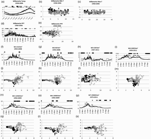
Table 4. Summary of observed evidence of climate change and river regulation signals at the 28 stream gauges in headwater sites and below dams in seven sub-basins of the Columbia River. Sub-basin designations are from . Gauge sites are designated H = headwater or B = below dam or H* = above dams but downstream of irrigated agriculture. Codes “x” and “o” were assigned based on visual evaluation of median/mean values in first, last decade (x), or counts of numbers of days with significant trends from regressions of log-transformed data (o).
Fig. 11 Changes in daily streamflow (Q) (a) to (d) on the Columbia River mainstem. (a), (b) Daily median Q values for each day of the water year from the first decade of record (grey line) and the last decade of record (black line). (c), (d) Scatter plots of daily median Q values for the entire period of record (x-axis) versus the change from the first decade to the last decade (y-axis). Symbols and units are same as in . Both stations are downstream of dams.
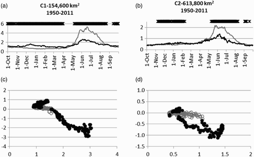
Fig. 12 Changes in flow as a function of basin area in the Columbia River basin, 1950–2010. (a) Numbers of days with significant increase in fractional flow, (b) number of days with significant decrease in fractional flow, (c) change in median daily flow, first decade (1950–1960 in most cases) to last decade (2000–2010), fall (September–November), (d) for winter (December–February), (e) for spring (March–May), (f) for summer (June–August).
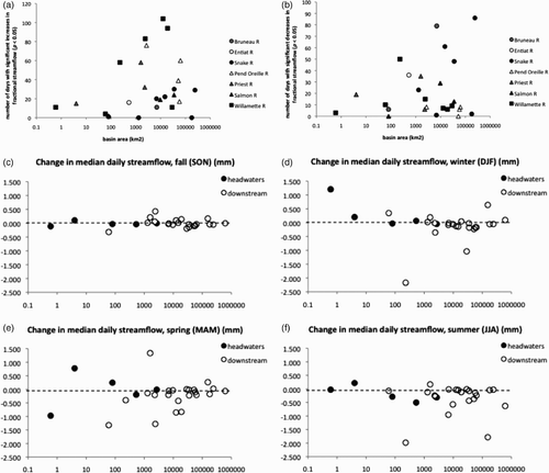
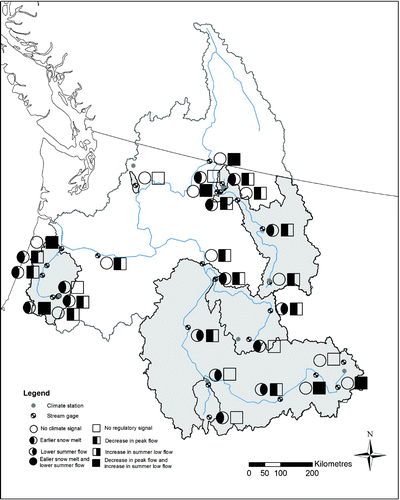
Fig. 13 Summary of changes observed in flows in seven principal sub-basins and mainstem of the Columbia River basin, 1950–2010. For each gauge, the circle symbol shows evidence of the expected climate signal from climate change (earlier spring peak, decreased late summer flow), and the square symbol shows evidence of the expected climate signal from flow regulation (reduced spring peak, increased late summer flow).