Figures & data
Fig. 1 Study area: Canadian Columbia River basin (light green) and climatic sub-regions.
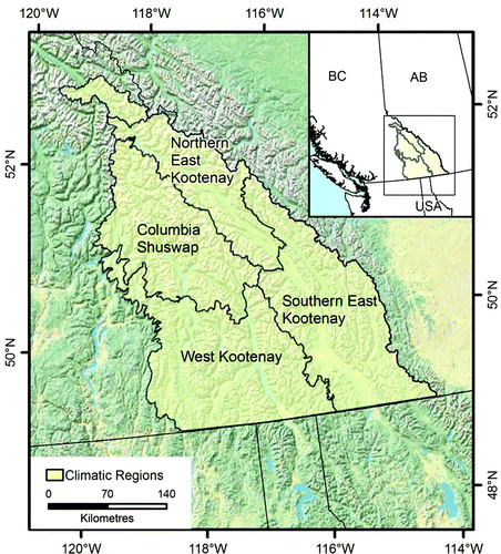
Fig. 2 Historical simulations of annual mean temperature (left) and annual total precipitation (right) for the Canadian Columbia Basin. The top row displays high-resolution (approximately 4 km) climatologies from ClimateWNA (www.climatewna.com; Wang et al., Citation2012), and the middle and bottom rows display climatologies from two RCM historical simulations.
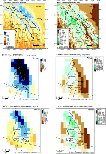
Table 1. RCM and GCM acronyms, full names, and modelling groups within the NARCCAP project.
Table 2. RCM future projection ensemble members and driving GCMs. An X indicates an ensemble member used in this study driven by the GCM listed in the row for the RCM listed in the column.
Table 3. Comparison of NCEP2 and NCEP2-driven RCM annual anomalies from their respective 1980–2000 averages to CANGRID 1980–2000 anomalies from average as well as bias (difference of 1980–2000 average from CANGRID) for annual mean temperature and precipitation for the Columbia Basin.
Fig. 3 Annual temperature (upper panel) and precipitation (lower panel) for the Columbia Basin as simulated by NCEP2-driven NARRCAP RCMs (dashed lines) and from gridded and station observations (solid lines) as anomalies from each record's 1980–2000 period average.
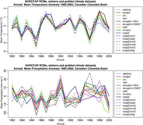
Table 4. Summary of projected temperature changes for all individual grid boxes from all eight runs. In addition to minimum, median, and maximum values, the 10th, 25th, 75th, and 90th percentiles of all changes are shown. See Section 2 for definitions of the indices. The 10th and 90th percentiles, in italics, are used to report the range of projected change.
Fig. 4 Projected annual mean temperature (top row), warm days in summer (TX90p – middle row) and cool nights in winter (TN10p – bottom row) for the 2050s from two RCM simulations.
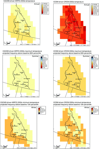
Fig. 5 Seasonal ranges in temperature (left) and precipitation (right) projected change over multiple time intervals from 30 global climate model projections for the Canadian Columbia Basin. Historical mean and variability (represented by ±1 standard deviation of historical values) were obtained from gridded observations (CANGRID), while the GCM projections were obtained from 15 models including both the SRES A2 and B1 scenarios. Also shown for reference (purple dots) are the four GCM projections that provide the 2050s driving conditions for the eight NARCCAP RCM simulations. All projected changes shown are from their respective 1971–2000 baseline.
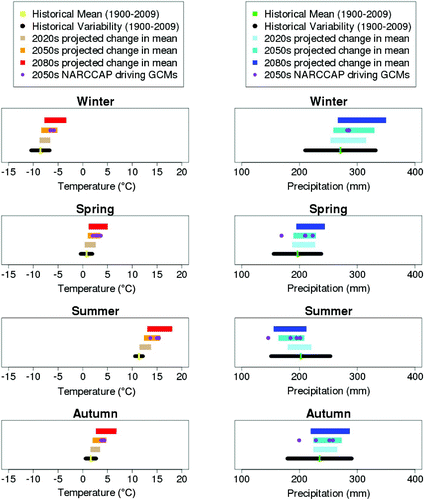
Table 5. Summary of projected precipitation changes for all individual grid boxes from all eight runs and all months. In addition to minimum, median, and maximum values, the 10th, 25th, 75th, and 90th percentiles of all changes are shown. See Section 2 for definitions of the indices. The 10th and 90th percentiles, in italics, are used to report the range of projected change.
Fig. 6 Precipitation projections for the 2050s from two of the eight NARCCAP RCM simulations. The top row displays annual mean monthly precipitation totals, and the bottom row displays moderately extreme precipitation (R95pTOT).
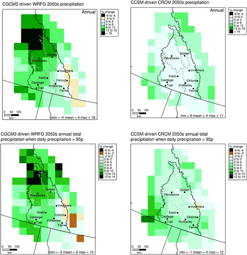
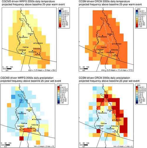
Table 6. Summary of projected change in the ratio of future frequency of return period to historical frequency for 25-year return periods for all individual grid boxes from all eight runs. In addition to minimum, median, and maximum values, the 10th, 25th, 75th, and 90th percentiles for all changes are shown. See Section 2 for more information about return period analysis. The 10th and 90th percentiles, in italics, are used to report the range of projected change.
Fig. 7 Frequency of projected 2050s 25-year return period temperature (top) and precipitation (bottom) as a ratio to occurrence during the 1971–2000 baseline from two of the eight NARCCAP RCM simulations.