Figures & data
Fig. 1 Map of the selected streamflow locations supported by the CBCCSP. Red dots indicate sites that are essentially unimpaired by human use or for which there is estimated modified* or naturalized flow. Sites without modified or natural flow estimates are shown in yellow. (*Modified flows are essentially naturalized flows with a consistent level of consumptive demand for water supply subtracted for the entire time series.)
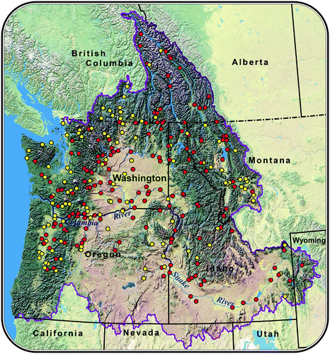
Table 1. Matrix of climate change projections included in the study. Numbers in the table show the number of GCM projections used for each downscaling approach and/or time period. (Note that data for the B1 emissions scenario were not available from one of the ten GCMs used as input to the HD and CD approaches.)
Fig. 2 Eleven sub-basins in the CRB used for large scale calibration (left panel). REVEL = Columbia River at Revelstoke Dam, CORRA = Kootenay River at Corra Linn Dam, WANET = Pend Oreille River at Waneta Dam, LIBBY = Kootenai (Kootenay) River at Libby Dam, DWORS = N. Fork Clearwater River at Dworshak Dam, MILNE = Snake River at Milner, ICEHA = Snake River at Ice Harbor Dam, PRIRA = Columbia River at Priest Rapids Dam, YAPAR = Yakima River at Parker, DALLE = Columbia River at The Dalles, OR, WILFA = Willamette River above falls at Oregon City. A number of sub-basins are nested within each other, as shown in the right panel along with their relative sizes. (For example, Dworshak and Milner are nested within the larger Ice Harbor sub-basin.).
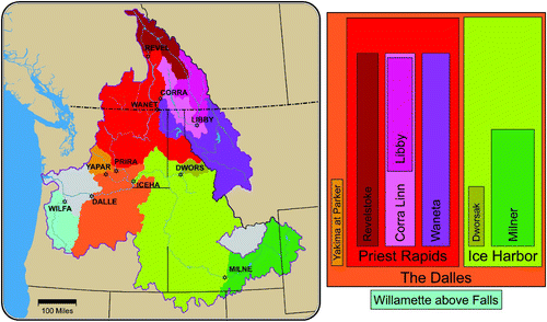
Fig. 3 Summary map of 80 streamflow locations (out of a total of 297) for which error statistics between simulated and naturalized flows were computed. The top two panels show the Nash Sutcliffe Efficiency (NSE) (left) and R 2 (right) for the calibration period, while the two lower panels show NSE (left) and R 2 (right) for the validation period. Small black dots indicate streamflow sites where naturalized flows were not available.
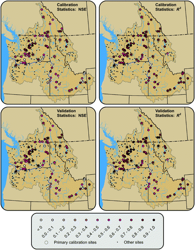
Table 2. Archived daily VIC hydrologic model output variables. The variables are displayed in the order that they are archived in the VIC output files. The far right column shows the method used to aggregate daily output to monthly values for each variable.
Fig. 4 Flow chart illustrating the post-processing steps used to produce the various hydrologic products served on the study website.
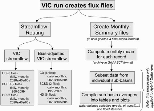
Fig. 5 Examples of summary plots for monthly snow water equivalent (SWE) (mm) (averaged over the upstream basin area) and raw streamflow not adjusted for bias (cubic metres per second) for the Skagit River at Mount Vernon. Blue traces show monthly averages for historical conditions; the pink bands show the range of projected change associated with each scenario and future time period; the red lines show the average of the future ensemble.
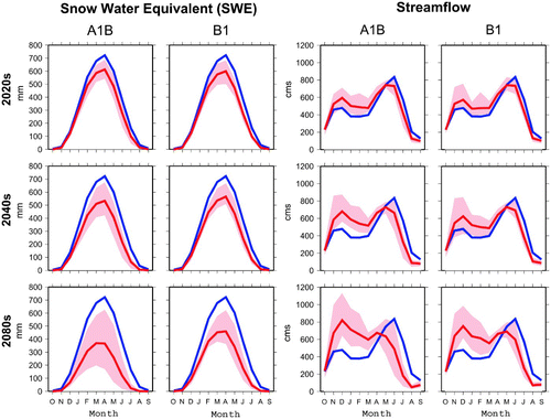
Fig. 6 Example of a summary plot for extreme high flows (Q20, Q50, Q100, left panels) and extreme low flows (7Q10, right panels) for the Skagit River at Mount Vernon for two emissions scenarios (A1B, B1) and three future time periods (2020s, 2040s, 2080s). Blue dots represent the historical values; the red dots show the range of values from the HD ensemble (10 or 9 values); black dashes show the mean of the HD ensemble, and the orange dots show the single value calculated for the CD projections.
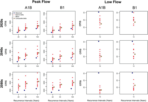
Fig. 7 Left panel: Simulated historical 1 April snow water equivalent (SWE) (upper right) and percentage changes in 1 April SWE for two emissions scenarios and three future time periods extracted from the CD VIC scenarios. Inset numbers at the upper left in the future projections are the percentage changes in 1 April SWE averaged over each grid cell in the entire domain. Right panel: Historical and projected future watershed classification (rain-dominant, transitional (mixed-rain-and-snow), snow-dominant) for 10-digit Hydrologic Unit Code watersheds, based on the long-term mean of the SWE2PR for each watershed. (1 April SWE and SWE2PR values were calculated using the CD VIC scenarios.)
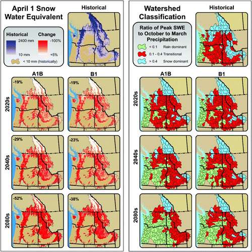
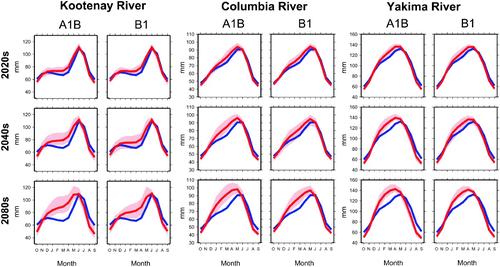
Fig. 8 Monthly mean hydrographs not adjusted for bias (water year: October–September) for four representative river sites in the PNW: Kootenay River at Corra Linn Dam (upper left), Columbia River at The Dalles, Oregon (upper right), Yakima River at Parker (lower left), and the Chehalis River at Grand Mound (lower right). Blue lines show the average historical values (1916–2006) (repeated in each panel). Pink bands show the range of nine or ten HD climate change scenarios for B1 and A1B emissions scenarios for three future time periods. Dark red lines show the average of the climate change ensemble.
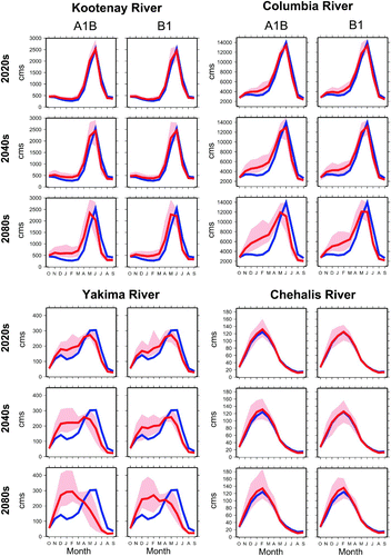
Fig. 9 Left panel: Historical estimates of summer (JJA) potential evapotranspiration (PET) (based on PET3, see ) (upper right) compared with percentage changes in PET for two emissions scenarios and three future time periods from the CD scenarios. Right panel: Historical estimates of summer AET (upper right) compared with percentage changes for the same CD scenarios.
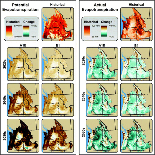
Fig. 10 Left panel: Changes in Q100 for 297 streamflow locations expressed as a ratio of Q100 for the future period to Q100 for the historical period based on the average of the nine or ten HD scenarios for the B1 and A1B emissions scenarios for three future time periods. Right panel: Same data shown as a scatter plot of the average ratio of Q100 for the 2040s A1B scenarios to Q100 for the historical period versus historical basin-average mid-winter (DJF) temperature in each case. Typical month of historical flooding events is shown by the colour of the dots in the scatter plot (legend inset in the upper right corner), by permission of I. Tohver, A.F. Hamlet, and S.-Y. Lee.
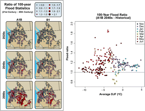
Fig. 11 Changes in 7Q10 for 297 river locations expressed as a ratio of 7Q10 for the future period to 7Q10 for the historical period based on the average of the nine or ten HD scenarios for the B1 and A1B emissions scenarios for three future time periods, by permission of I. Tohver, A.F. Hamlet, and S.-Y. Lee.
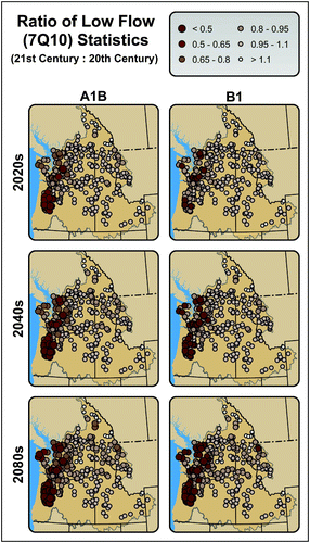
Fig. 12 Changes in monthly mean total column soil moisture (October–September) for three representative river sites in the PNW: Kootenay River at Corra Linn Dam (left), Columbia River at The Dalles, Oregon (centre), and Yakima River at Parker (right). Blue lines show average historical values (1916–2006) (repeated in each panel). Pink bands show the range of nine or ten HD climate change scenarios for B1 and A1B emissions scenarios for three future time periods. The dark red lines show the average of the climate change ensemble.