Figures & data
Fig. 1 Study area of the UCRB. The numbers 1–5 are the sub-basin outlets defined in .
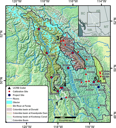
Table 1. Study area physical description and 1961–90 annual hydroclimatology.
Table 2. Global climate model and SRES scenario selection summary.
Table 3. Summary of calibration and validation results for Columbia River sub-basins for three performance measures. NS is the Nash–Sutcliffe values, LNS is the Nash–Sutcliffe coefficient of log-transformed discharge, and %VB is the percentage mean volume bias. BC Hydro project sites are indicated with bold text.
Fig. 2 Modelled daily streamflow compared with observed (COLAD and ELKAF) or naturalized (BCHAR and BCHKL) streamflow over the calibration and validation periods.
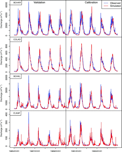
Table 4. Mean annual (ANN) and seasonal (DJF, MAM, JJA, and SON) temperatures by time period (1970s, 2020s, 2050s, and 2080s) and emissions scenarios (A2, A1B and B1).
Table 5. Mean annual and seasonal precipitation by time period (1970s, 2020s, 2050s, and 2080s) and emissions scenarios (A2, A1B, and B1).
Fig. 3 Mean (A2) 1 April SWE versus October to March precipitation and 1 April SWE for 1961–90 and changes for 2011–40, 2041–70, and 2071–2100 for the mean of the A2 scenario.
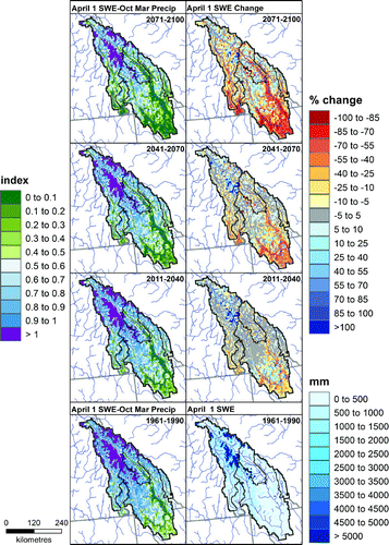
Fig. 4 Summer evapotranspiration and monthly soil moisture flux (June, July, and August) for 1961–90 and changes for 2011–40, 2041–70, and 2071–2100 for the mean of the A2 scenario.
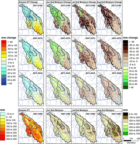
Fig. 5 Multivariate drainage plot of seasonal and annual change in runoff (%) for the 2080s versus the 1970s (line colour) and 1970s seasonal and annual runoff relative to the study area total (line thickness) for the mean of seven GCMs run under the A2 scenario. Note that the modelled drainage network only shows 2nd order and higher channel segments. Red dots denote outlets for the COLAD, BCHAR, ELKAF, and BCHKL basins. The total 1970s study area streamflow for each season is given in the bottom left of each panel as area-average runoff (mm) and discharge equivalent (m3 s−1).
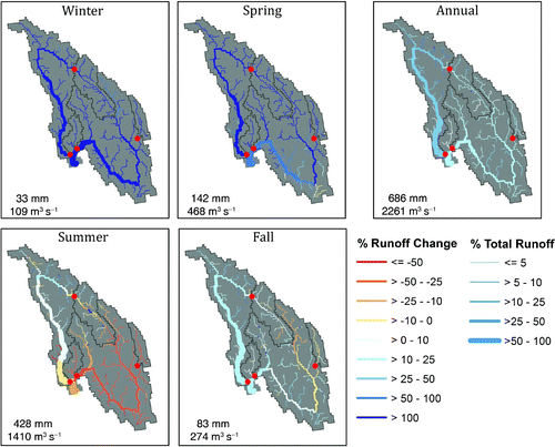
Fig. 6 Temperature and precipitation for the historical period (1970s) and the 2020s, 2050s, and 2080s for seven GCMs for A2 emissions scenarios for the Columbia River at Keenlyside Dam. The solid lines indicate the median of the historical (black), 2020s (blue), 2050s (green), and 2080s (red) and the dashed lines indicate the 5th and 95th percentiles of the seven GCMs, 30-year ensemble for each month. Light grey shows the range of the 25th to 75th percentiles, and dark grey shows the 5th to 95th percentiles for the historical period. The blue diamond, green plus-sign, and red dot symbols denote significant differences (α = 0.05) between the 1970s and 2020s, 2050s and 2080s periods, respectively.
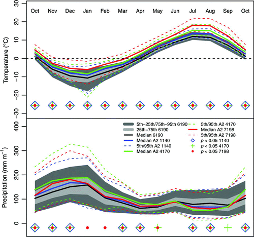
Fig. 7 As in but for rainfall, snowfall, evaporation, snowmelt, and runoff.
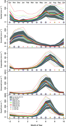
Fig. 8 The spread of the mean annual discharge (grey) and 30-year means of mean annual discharge (horizontal black lines at 1961–90, 2011–40, 2041–70, 2071–98) are shown for 20 scenarios for a) the Columbia River at Keenlyside Dam (BCHAR) and b) the Kootenay River at Kootenay Canal (BCHKL). The means of the A1B, A2, and B1 scenarios (green, red, and light blue) are shown with solid lines, along with the 30-year means for the 2020s, 2050s, and 2080s.
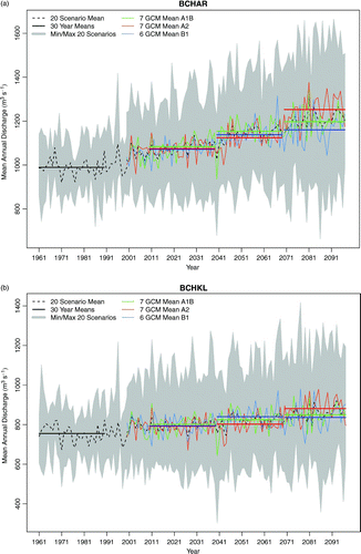
Table 6. Percentage change in median monthly streamflow for each sub-basin in the 2080s under each emissions scenario (A2, A1B, and B1). Historical values for 1961–90 (1970s) shown in italics.
Fig. 9 Monthly discharge for four sub-basins. Solid lines indicate the median of the baseline (black), B1 (blue), A2 (green), and A1B (red) and dashed lines the 5th and 95th percentiles of the seven GCMs (six for B1) for a given emissions scenario, 30-year ensemble for each month. Light grey shows the range of the 25th to 75th percentiles and dark grey the 5th to 95th percentiles for the base period.
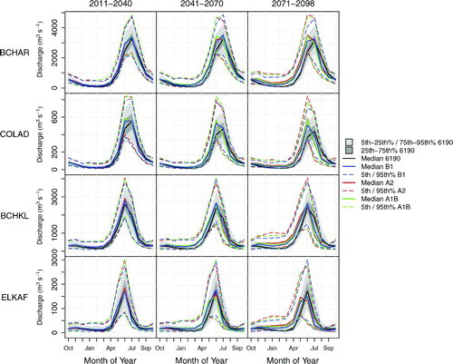
Fig. 10 Seven day, 10-year return period low flow for the Columbia River at Donald (COLAD), the Columbia River at Keenlyside (BCHAR), the Kootenay River at Kootenay Canal (BCHKL), and Elk River at Fernie (ELKAF) under the B1, A2, and A1B emissions scenario for the 1970s, 2020s, 2050s, and 2080s. Each box plot illustrates the median and inter-quartile range and the whiskers the upper and lower limits of the 30-year periods.
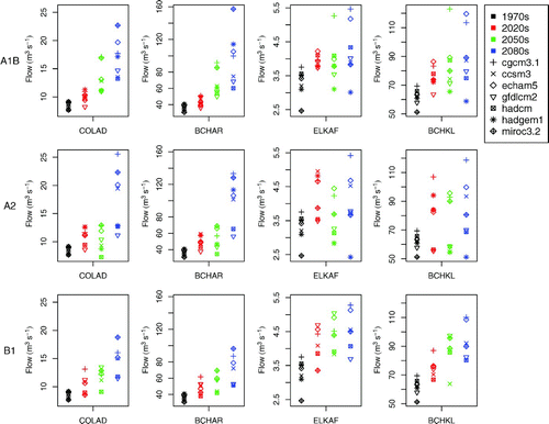
Fig. 11 As in but for 25-year return period peak flow.
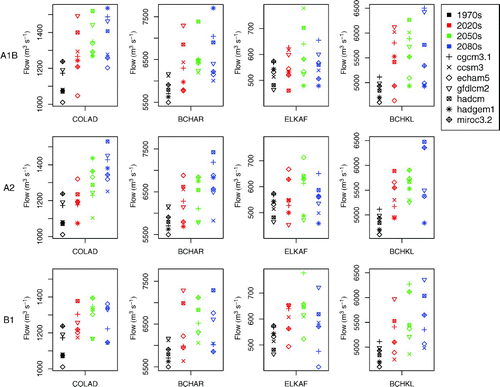
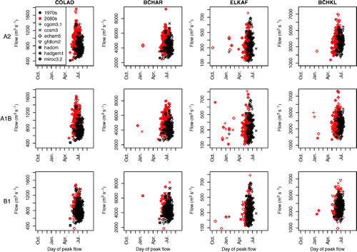
Fig. 12 Annual maximum peak-flow magnitude versus day of peak flow for the Columbia River at Donald (COLAD), the Columbia River at Keenlyside (BCHAR), the Kootenay River at Kootenay Canal (BCHKL), and Elk River at Fernie (ELKAF) under the B1, A2, and A1B emissions scenario for the 1970s and 2080s.