Figures & data
Figure 1 Reservoirs of the Missouri River. Individual maps show bays and open-water areas and approximate upstream limit of sampling.
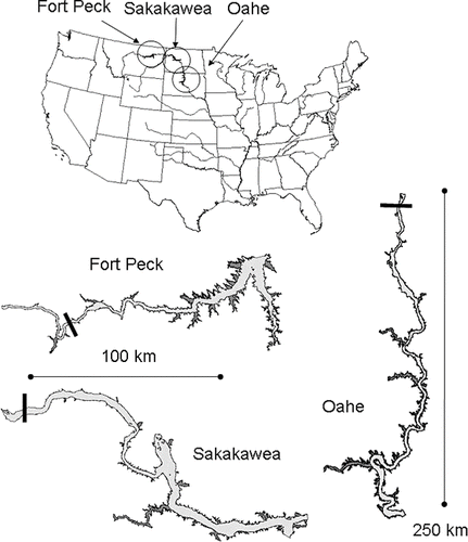
Table 1 Description of Oahe, Sakakawea, and Fort Peck from this study1 and CitationBenson (1988) 2.
Table 2 Area-weighted mean (and standard error) of water quality variables for the whole-reservoir, open-water areas, and bays in the first sampling years: Oahe (2001), Sakakawea (2002), and Fort Peck (2003).
Figure 2 Average monthly reservoir water elevations (feett above mean sea level). Circles indicate sampling periods (July–August).
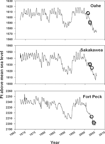
Table 3 Summary of water chemistry and sediment analytical methods.
Figure 3 Area-weighted mean (± standard error) specific conductivity (μS/cm) approximately 2 m from the bottom, and water column SO= 4 (μg/L), Ca (μg/L), SiO2 (μg/L), NO3+NO2 (μg N/L), and total N (μg N/L) in riverine, transitional, and lacustrine zones of each reservoir. First year data are shown.
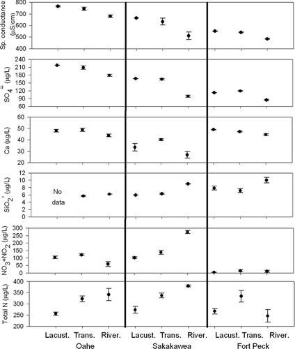
Figure 4 Area-weighted mean (±95% confidence bounds) concentrations of the atomic ratio of N:P, total suspended solids (TSS; mg/L), total organic carbon (μg/L), and, chlorophyll a (μg/L), Secchi depth (m), and total P (μg/L) in each reservoir. Filled circles are 2001, 2002, and 2003 for Oahe, Sakakawea, and Fort Peck, respectively. Open circles are 2002, 2003, and 2004 for Oahe, Sakakawea, and Fort Peck, respectively.
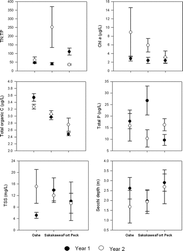
Figure 5 Cumulative distribution functions of the percentage (%) and area (km2) of Lake Oahe with increasing chlorophyll, Secchi depth, and total P (bold lines and top X axis of each panel) and TSI for chlorophyll, Secchi depth, and total P (thin lines and bottom X axis of figure). Data from the first and second sampling years are denoted by solid and dotted lines, respectively.
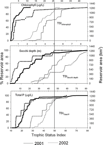
Figure 6 Cumulative distribution functions of the percentage (%) and area (km2) of Lake Sakakawea with increasing chlorophyll, Secchi depth, and total P (bold lines and top X axis of each panel) and TSI for chlorophyll, Secchi depth, and total P (thin lines and bottom X axis of figure). Data from the first and second sampling years are denoted by solid and dotted lines, respectively.
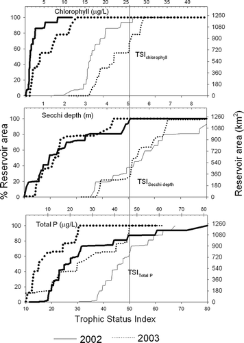
Figure 7 Cumulative distribution functions of the percentage (%) and area (km2) of Fort Peck Lake with increasing chlorophyll, Secchi depth, and total P (bold lines and top X axis of each panel) and TSI for chlorophyll, Secchi depth, and total P (thin lines and bottom X axis of figure). Data from the first and second sampling years are denoted by solid and dotted lines, respectively.
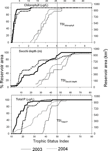
Figure 8 Area-weighted mean (± standard error) of TSI for chlorophyll, Secchi depth, and total phosphorus in riverine, transitional, and lacustrine zones of each reservoir. First year data are shown.
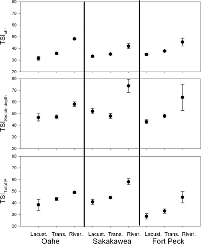
Figure 9 Area-weighted mean (± standard error) temperatures (°C), dissolved oxygen (DO) concentrations (mg/L), and % DO saturation sampled approximately 2 m from the bottom in each reservoir in each year. Filled circles are 2001, 2002, and 2003 for Oahe, Sakakawea, and Fort Peck, respectively. Open circles are 2002, 2003, and 2004 for Oahe, Sakakawea, and Fort Peck, respectively.
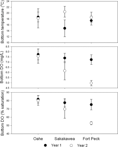
Figure 10 Cumulative distribution functions of the proportion and area (±95% confidence bounds) of each reservoir with increasing near-bottom DO concentrations (mg/L).
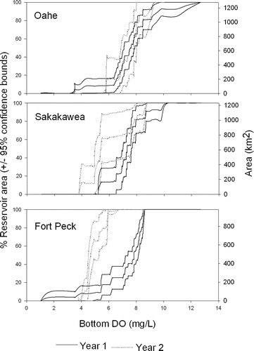
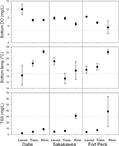
Figure 11 Area-weighted mean (± standard error) DO (mg/L), temperature (°C) at approximately 2 m from the bottom and water column total suspended solids (TSS; mg/L) in riverine, transitional, and lacustrine zones of each reservoir. First year data are shown. Nominal criteria for cold-water habitat (5 mg/L DO, 15°C, and 30 mg/L total suspended solids) are shown as horizontal lines.