Figures & data
Table 1 Sources of data for the estimation of the areas of potential regeneration safe-sites under past, current, and potential future lake water management. MLIT: data obtained by the Ministry of Land, Infrastructure, and Transport of Japan.
Table 2 Survival rate of 12 helophytic species after exposure to the inundation treatment. All seedlings in the non-inundated treatment survived during the same period.
Figure 1 Relative frequency of the ground heights of emergent vegetation in 1967 (mean ± SD: 0.176 ± 0.366, n = 2539) and 2005 (0.324 ± 0.104, n = 2313).
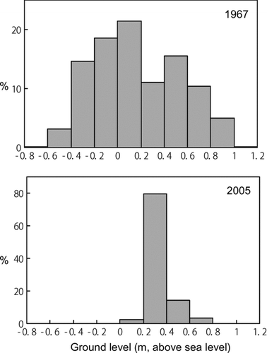
Figure 2 Seasonal water-level patterns in Lake Kasumigaura, Japan. The monthly average, 25th–75th percentiles, and 10th–90th percentiles are shown prior to water-level management using a water gate (1960–1969, left graph) and for more recent years (1996–2005, right graph) subsequent to the implementation of the management regime.
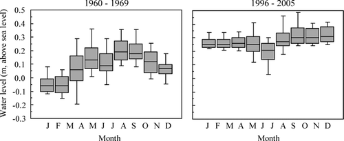
Table 3 Estimated area of potential regeneration safe-sites (PRS) in the past and current lake conditions under different criteria: the ground surface is inundated for less than d consecutive days during the period from 1 April to 15 May (d= 1, 2, …7). Means and SDs were shown with the results of the 1 way ANOVAs.
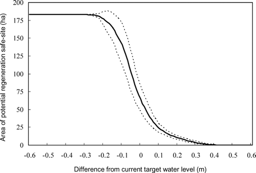
Figure 3 Shifts in the estimated area of potential regeneration safe-sites for lakeshore helophytes due to changes in the target water level used for lake water management. Solid and dotted lines represent the mean (n = 9) and 95% confidence intervals, respectively.