Figures & data
Table 1 Morphometric and watershed characteristics of Lake Waco.
Figure 1 Lake Waco bathymetric map indicating North Bosque River (NBR), South Bosque River (SBR), deep-water upwelling (DWU), and lacustrine (LAC) sampling stations. Contour lines represent 5 ft (1.5 m) depth intervals and become deeper near dam. Bathymetry data were post-processed from original source (TWDB 2003). Inset map indicates McLennan County, TX
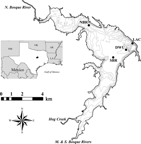
Figure 2 Local wind patterns during study (NOAA 2009). Data were temporally grouped from (A) Nov 2003 to May 2004 and (B) Jun to Oct 2004 to show contrasting wind patterns.
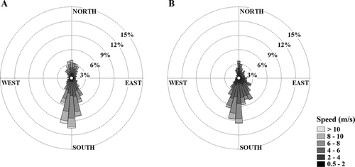
Figure 3 North Bosque River discharge (solid line; USGS 2008) and Lake Waco water surface elevation (broken line; USACE 2008) during study.
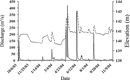
Table 2 Annual averages (± standard deviations) for TSS net and gross sedimentation rates (g/m2/d), resuspension rates (gross−net sedimentation rates, g/m2/d), and percent resuspension (resuspen-
sion rate/gross sedimentation rate, %) by sampling station.
Table 3 Inorganic and organic percent composition of TSS in photic and bottom sediment traps and resuspended materials by sampling station. Values reported as annual averages ± standard deviations.
Figure 4 TSS resuspension rate (bottom trap sedimentation rate − photic trap sedimentation rate) through time by sampling station.
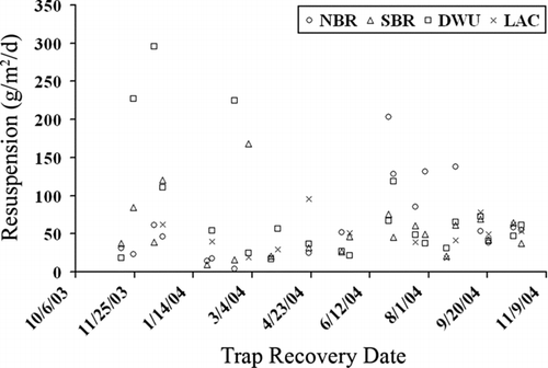
Figure 5 TSS percent resuspension (resuspension rate/bottom trap sedimentation rate) through time by sampling station.
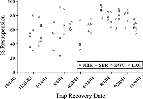
Table 4 Linear regression models of TSS percent resuspension (arcsine squareroot transformed) as a function of average mixing depth (log10 transformed) based on daily resultant wind speeds and directions. Models are presented for significant regressions (α= 0.05) only.
Table 5 Linear regression models of TSS percent resuspension (arcsine squareroot transformed) as a function of mixing depth-to-station depth ratio (zmix:zsite; log10 transformed) based on daily resultant wind speeds and directions. Models are presented for significant regressions (α= 0.05) only.
Table 6 Linear regression models of TSS percent resuspension (arcsine squareroot transformed) as a function of average North Bosque River discharge (log10 – log10 transformed). Models are presented for significant regressions (α= 0.05) only.
Table 7 Multiple linear regression model of TSS percent resuspension (arcsine squareroot transformed) as a function of average North Bosque River discharge (log10 – log10 transformed) and z mix :z site (log10 transformed) based on daily resultant wind speeds and directions for the South Bosque River station.
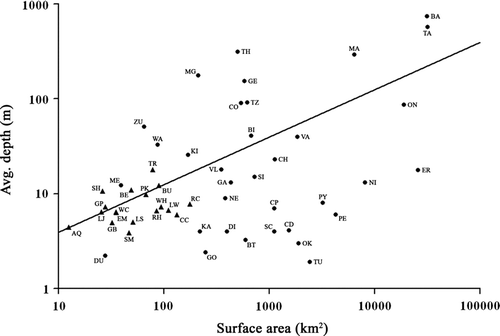
Figure 6 Central Texas reservoirs (triangles; TWDB 2009) and large world natural lakes (circles; ILEC 2009) characterized by mean depth and surface area (modified from CitationHavens et al. 2007). Trendline represents dynamic ratio (DR =√surface area (in km2)/avg. depth (in m); Håkanson 1982) of 0.8 with lakes below this trendline (DR > 0.8) being increasingly affected by wind–wave mixing. Central Texas reservoirs include Aquilla (AQ), Belton (BE), Buchanan (BU), Cedar Creek (CC), Eagle Mountain (EM), Granbury (GB), Grapevine (GP), Lewisville (LW), Limestone (LS), Lyndon B. Johnson (LJ), Possum Kingdom (PK), Ray Hubbard (RH), Richland-Chambers (RC), Somerville (SM), Stillhouse Hollow (SH), Travis (TR), Waco (WC), and Whitney (WH). World natural lakes include Baikal (BA), Biwa (BI), Balaton (BT), Chad (CD), Champlain (CH), Constance (CO), Chapala (CP), Dianchi (DI), Dong-hu (DU), Erie (ER), Gatiun (GA), Geneva (GE), George (GO), Kasumiguara (KA), Kinneret (KI), Malawi (MA), Mendota (ME), Maggiore (MG), Neagh (NE), Nicaragua (NI), Okeechobee (OK), Ontario (ON), Peipsi (PE), Poyang (PY), St. Clair (SC), Simcoe (SI), Tanganyika (TA), Tahoe (TH), Tai-hu (TU), Taupo (TZ), Vattern (VA), Valencia (VL), Washington (WA), and Zurich (ZU).