Figures & data
Figure 1 Lake Mead (source: http://earthobservatory.nasa.gov/Features/LakeMead). Numbers 1, 2 and 3 represent the in-lake real-time monitoring sites named Las Vegas Bay, Sentinel Island and Virgin Basin, respectively.
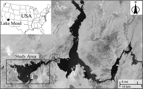
Figure 2 Bottom elevations and boundary location in model domain.
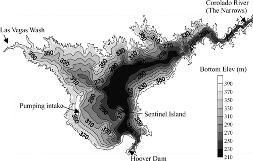
Figure 3 Time series of the simulated water level (solid line) and the observed data (dotted points) at Sentinel Island in 2005.
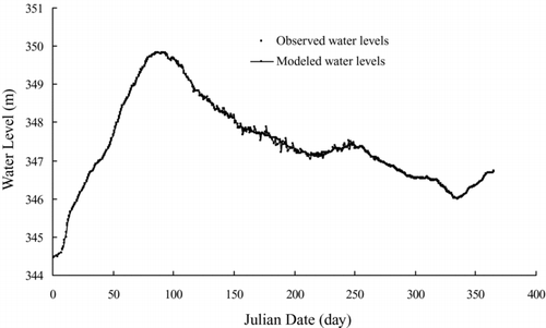
Table 1 Calibration parameters for the Lake Mead hydrodynamic simulation.
Figure 4 Comparison of simulated temperature profile (solid line) and the observed data (dotted points) at Las Vegas Bay (LVB) and Sentinel Island (SI) on Day 100, 200 and 300 in 2005. (a) LVB at Day 100; (b) LVB at Day 200; (c) LVB at Day 300; (d) SI at Day 100; (e) SI, Day 200; (f) SI at Day 300.
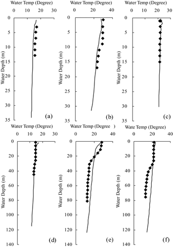
Figure 5 Time series of temperature calibration results at surface, middle and bottom water column from 1 January to 31 December 2005 at Sentinel Island.
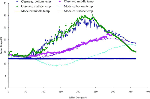
Figure 6 Water depths in the first day of high-stage.
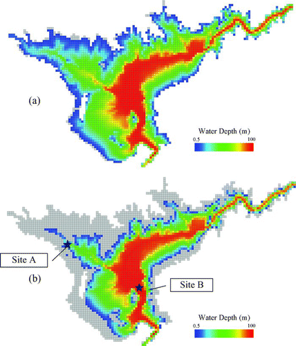
Figure 7 Calculated time series of temperature at sites A (a) and B (b) for the high-stage condition.
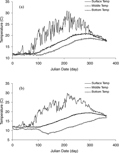
Figure 8 Calculated time series of water age at sites A (a) and B (b) for the high-stage condition.
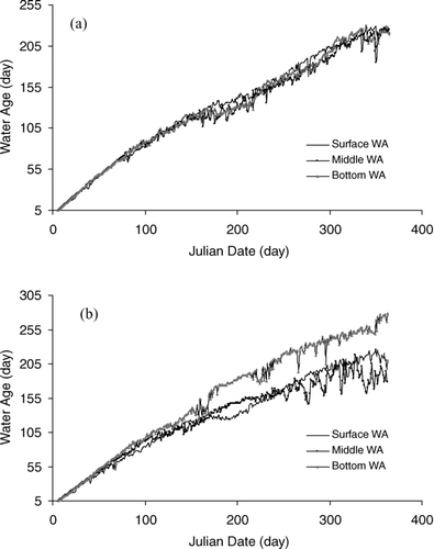
Figure 9 Comparison of calculated time series of depth averaged temperature (a) and water age (b) at sites A and B.
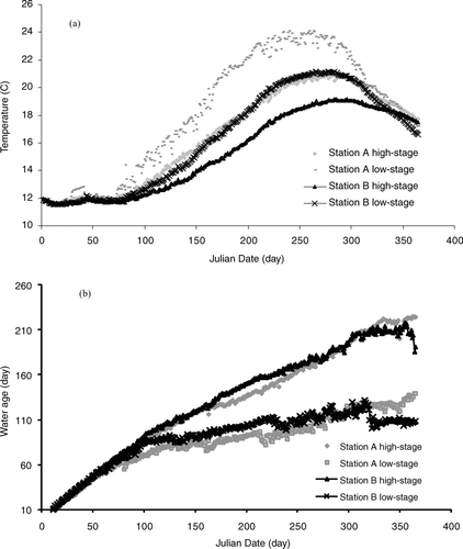
Figure 10 The spatial distribution of calculated temperature differences (ΔT) between high- and low-stage situations at Day 219. ΔT means temperature in high-stage subtracted from the temperature in low-stage. (a) Depth averaged ΔT, (b) Surface ΔT and (c) Bottom ΔT.
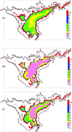
Figure 11 Comparison of calculated temperature at sites B between high- and low-stage situations.
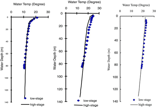
Figure 12 The spatial distribution of calculated water age differences (ΔWA) at Day 365 between high- and low-stage situations. ΔWA represents water age of high-stage subtracted from that of low-stage (a) Depth averaged ΔWA, (b) Surface ΔWA and (c) Bottom ΔWA.
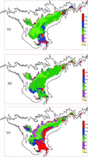
Table 2 Percentage of the lake area with different water age differences (ΔWA) at Day 365 between high- and low-stage simulations at different water depths.
Figure 13 Time series of bottom temperature at site B using 3 different vertical resolutions: 14, 20 and 30 levels from 1 March to 31 October 2005.
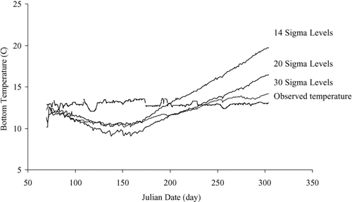
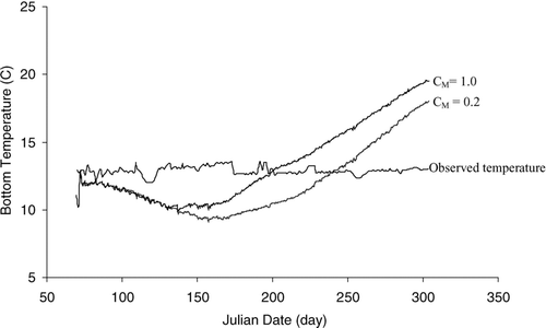
Figure 14 Time series of bottom temperature at site B using two CM values, 0.2 and 1.0, with 14 sigma layers from 1 March to 31 October 2005.